
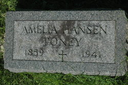
Amelia Hoffman Toney
| Birth | : | 25 Feb 1859 |
| Death | : | 16 Apr 1941 Clinton, Clinton County, Iowa, USA |
| Burial | : | Mount Pisgah Baptist Church Cemetery, Mount Pisgah, Kershaw County, USA |
| Coordinate | : | 34.5783234, -80.4057922 |
frequently asked questions (FAQ):
-
Where is Amelia Hoffman Toney's memorial?
Amelia Hoffman Toney's memorial is located at: Mount Pisgah Baptist Church Cemetery, Mount Pisgah, Kershaw County, USA.
-
When did Amelia Hoffman Toney death?
Amelia Hoffman Toney death on 16 Apr 1941 in Clinton, Clinton County, Iowa, USA
-
Where are the coordinates of the Amelia Hoffman Toney's memorial?
Latitude: 34.5783234
Longitude: -80.4057922
Family Members:
Spouse

Children
Flowers:


Nearby Cemetories:
1. Mount Pisgah Baptist Church Cemetery
Mount Pisgah, Kershaw County, USA
Coordinate: 34.5783234, -80.4057922
2. House Of Prayer Church Cemetery
Bethune, Kershaw County, USA
Coordinate: 34.5632990, -80.3929720
3. New Testament Missionary Baptist Church
Mount Pisgah, Kershaw County, USA
Coordinate: 34.5989150, -80.4219440
4. Sandy Grove United Methodist Church Cemetery
Jefferson, Chesterfield County, USA
Coordinate: 34.5958430, -80.4332500
5. Faith Family Church Cemetery
Jefferson, Chesterfield County, USA
Coordinate: 34.5953700, -80.4354500
6. Horton Family Cemetery
Angelus, Chesterfield County, USA
Coordinate: 34.5833370, -80.3662590
7. Pine Grove Freewill Baptist Church Cemetery
Kershaw County, USA
Coordinate: 34.5979290, -80.4413560
8. Pine Grove Free Will Baptist Church Cemetery
Jefferson, Chesterfield County, USA
Coordinate: 34.5980190, -80.4413200
9. Evans Family Cemetery
Jefferson, Chesterfield County, USA
Coordinate: 34.5605810, -80.3671110
10. Sandy Run Missionary Baptist Church Cemetery
Angelus, Chesterfield County, USA
Coordinate: 34.5685920, -80.3596050
11. Macedonia Baptist Church Cemetery
Angelus, Chesterfield County, USA
Coordinate: 34.5893470, -80.3592710
12. Crossroads Baptist Church Cemetery
Kershaw, Lancaster County, USA
Coordinate: 34.6021580, -80.4470700
13. Bethel Baptist Church Cemetery
Jefferson, Chesterfield County, USA
Coordinate: 34.6209560, -80.3812050
14. Stroud Cemetery
Kershaw County, USA
Coordinate: 34.5677986, -80.4705963
15. Mount Elon United Methodist Church Cemetery
Jefferson, Chesterfield County, USA
Coordinate: 34.5766580, -80.3338600
16. Fork Creek United Methodist Church Cemetery
Jefferson, Chesterfield County, USA
Coordinate: 34.6338997, -80.3743973
17. Oak Grove Baptist Church Cemetery
Jefferson, Chesterfield County, USA
Coordinate: 34.6332092, -80.3597870
18. Baker-Kirkley Family Cemetery
Jefferson, Chesterfield County, USA
Coordinate: 34.6394320, -80.3712550
19. Mount Canaan Baptist Church Cemetery
Jefferson, Chesterfield County, USA
Coordinate: 34.6452780, -80.3963940
20. Rocky Creek Presbyterian Church Cemetery
Chesterfield County, USA
Coordinate: 34.6195700, -80.3393860
21. Morning Star Holiness Church Cemetery
Jefferson, Chesterfield County, USA
Coordinate: 34.6469340, -80.3967790
22. Angelus Chapel AME Zion Cemetery
Angelus, Chesterfield County, USA
Coordinate: 34.5954290, -80.3229740
23. Flat Creek Baptist Church Cemetery
Kershaw, Lancaster County, USA
Coordinate: 34.6284660, -80.4668510
24. Beauford Baptist Church Cemetery
McBee, Chesterfield County, USA
Coordinate: 34.5293150, -80.3395620