
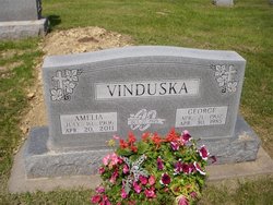
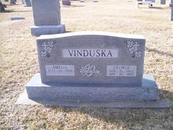
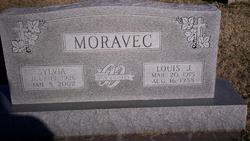
Amelia Neuwirth Vinduska
| Birth | : | 10 Jul 1906 |
| Death | : | 20 Apr 2011 Marion, Marion County, Kansas, USA |
| Burial | : | Buckhorn Waterford Cemetery, Buckhorn, Jackson County, USA |
| Coordinate | : | 42.0607986, -90.7517014 |
| Plot | : | sec a row 8 plot 3e |
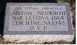
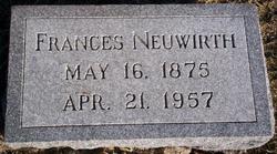
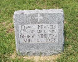
| Description | : | Amelia was born near Lost Springs to Anton & Frances Malek Neuwirth. On october 27, 1925 she marreid George Vinduska in St. John Nep. She was an active member of St. John Nepomucene Cathoic Church. She is the mother of Edwin (infant), Sylvia, Harold, Kenneth & Margie. At the time of her death, she had 17 grandchildren, 34 great-grandchildren and 10 great great grandchildren. |
frequently asked questions (FAQ):
-
Where is Amelia Neuwirth Vinduska's memorial?
Amelia Neuwirth Vinduska's memorial is located at: Buckhorn Waterford Cemetery, Buckhorn, Jackson County, USA.
-
When did Amelia Neuwirth Vinduska death?
Amelia Neuwirth Vinduska death on 20 Apr 2011 in Marion, Marion County, Kansas, USA
-
Where are the coordinates of the Amelia Neuwirth Vinduska's memorial?
Latitude: 42.0607986
Longitude: -90.7517014
Family Members:
Parent
Spouse
Siblings
Children

Flowers:


Nearby Cemetories:
1. Buckhorn Waterford Cemetery
Buckhorn, Jackson County, USA
Coordinate: 42.0607986, -90.7517014
2. Goddard Cemetery
Maquoketa, Jackson County, USA
Coordinate: 42.0391998, -90.7335968
3. Pence Cemetery
Baldwin, Jackson County, USA
Coordinate: 42.0746994, -90.8106003
4. Busch Cemetery
Clinton County, USA
Coordinate: 41.9996986, -90.7818985
5. Mount Hope Cemetery
Maquoketa, Jackson County, USA
Coordinate: 42.0615616, -90.6619720
6. Sacred Heart Cemetery
Maquoketa, Jackson County, USA
Coordinate: 42.0583496, -90.6617966
7. Hershberger Cemetery
Baldwin, Jackson County, USA
Coordinate: 42.0772309, -90.8418011
8. Holy Trinity Catholic Cemetery
Baldwin, Jackson County, USA
Coordinate: 42.0770000, -90.8420000
9. Elwood Cemetery
Elwood, Clinton County, USA
Coordinate: 41.9935989, -90.7307968
10. Esgate Cemetery
Maquoketa, Jackson County, USA
Coordinate: 42.1292000, -90.7142029
11. Union Cemetery
Brookfield Township, Clinton County, USA
Coordinate: 42.0182991, -90.6694031
12. Washington Cemetery
Clinton County, USA
Coordinate: 42.0119019, -90.8399963
13. Tilton Cemetery
Jackson County, USA
Coordinate: 42.1236000, -90.6798000
14. East Iron Hill Cemetery
Farmers Creek Township, Jackson County, USA
Coordinate: 42.1465797, -90.7591019
15. Reel Cemetery
Baldwin, Jackson County, USA
Coordinate: 42.1049995, -90.8510971
16. West Iron Hill Cemetery
Jackson County, USA
Coordinate: 42.1460000, -90.7686000
17. Monmouth Cemetery
Monmouth, Jackson County, USA
Coordinate: 42.0679300, -90.8798400
18. Bridgeport Cemetery
Maquoketa, Jackson County, USA
Coordinate: 42.0906000, -90.6267000
19. Rustic Park
Clinton County, USA
Coordinate: 41.9712334, -90.8088684
20. Smithtown Cemetery
Lost Nation, Clinton County, USA
Coordinate: 41.9955000, -90.8555000
21. Willison Cemetery
Jackson County, USA
Coordinate: 42.1646000, -90.7783000
22. Lost Nation Cemetery
Lost Nation, Clinton County, USA
Coordinate: 41.9654000, -90.8184000
23. Sacred Heart Cemetery
Lost Nation, Clinton County, USA
Coordinate: 41.9659500, -90.8199500
24. Sutton Cemetery
Fulton, Jackson County, USA
Coordinate: 42.1677000, -90.7143000