
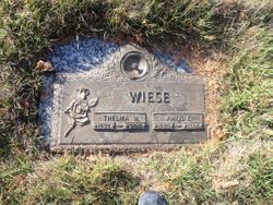

Amos Fred Nels Wiese
| Birth | : | 21 May 1920 Manilla, Crawford County, Iowa, USA |
| Death | : | 18 Jun 1998 Denver, Denver County, Colorado, USA |
| Burial | : | North Lawn Cemetery, Spencer, Clay County, USA |
| Coordinate | : | 43.1600000, -95.1470000 |
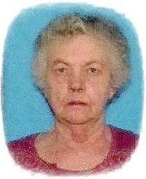
| Description | : | Amos Wiese, 78, Golden Colorado formerly of Spencer, died Thursday, June 18, 1998 at Saint Anthony's Hospital, Denver, Colorado Services were held Monday, June 22 at the Warner Chapel, Spencer, with the Rev. Milo Sheldon officiating Casket Bearers were Matthew Wiese, Samuel Wiese, Merlin Wiese, Walter Wiese, Larry Vodenik and Roger Wiese Burial was at Northlawn Memorial Park, Spencer, with Warner Funeral Home of Spencer in charge of arrangements Amos Fred Nels Wiese, the son of Henry and Emma Boyens Wiese was born Mary 21, 1920 in Manilla. He attended school and worked in Audubon and Manning On November 7,... Read More |
frequently asked questions (FAQ):
-
Where is Amos Fred Nels Wiese's memorial?
Amos Fred Nels Wiese's memorial is located at: North Lawn Cemetery, Spencer, Clay County, USA.
-
When did Amos Fred Nels Wiese death?
Amos Fred Nels Wiese death on 18 Jun 1998 in Denver, Denver County, Colorado, USA
-
Where are the coordinates of the Amos Fred Nels Wiese's memorial?
Latitude: 43.1600000
Longitude: -95.1470000
Family Members:

Spouse
Siblings
Flowers:


Nearby Cemetories:
1. North Lawn Cemetery
Spencer, Clay County, USA
Coordinate: 43.1600000, -95.1470000
2. Dewey Readmore Books Memorial
Spencer, Clay County, USA
Coordinate: 43.1403999, -95.1443024
3. Riverside Cemetery
Spencer, Clay County, USA
Coordinate: 43.1441994, -95.1671982
4. Fairview Cemetery
Clay County, USA
Coordinate: 43.1899986, -95.0800018
5. Evergreen Cemetery
Clay County, USA
Coordinate: 43.2052994, -95.2086029
6. Dickens Cemetery
Dickens, Clay County, USA
Coordinate: 43.1280000, -95.0155000
7. Swedish Lutheran Cemetery
Royal, Clay County, USA
Coordinate: 43.0683000, -95.2350000
8. Little Sioux Lutheran Cemetery
Milford, Dickinson County, USA
Coordinate: 43.2702065, -95.2109528
9. Rosehill Cemetery
Clay County, USA
Coordinate: 43.0368996, -95.0919037
10. First Reformed Cemetery
Clay County, USA
Coordinate: 43.2399500, -95.2889000
11. Lone Tree Cemetery
Everly, Clay County, USA
Coordinate: 43.1411018, -95.3347015
12. Milford Cemetery
Milford, Dickinson County, USA
Coordinate: 43.3092003, -95.1481018
13. Lincoln Cemetery
Rossie, Clay County, USA
Coordinate: 43.0111008, -95.2313995
14. Calvary Cemetery
Milford, Dickinson County, USA
Coordinate: 43.3213997, -95.1688995
15. Logan Township Cemetery
Clay County, USA
Coordinate: 43.0489006, -94.9747009
16. Liberty Cemetery
Greenville, Clay County, USA
Coordinate: 42.9897003, -95.1417007
17. Willow Creek Cemetery
Royal, Clay County, USA
Coordinate: 43.0214005, -95.2885971
18. Clay Center Cemetery
Royal, Clay County, USA
Coordinate: 43.0410995, -95.3272018
19. TriMello Cemetery
Royal, Clay County, USA
Coordinate: 43.0682983, -95.3728027
20. Crown Hill Cemetery
Ruthven, Palo Alto County, USA
Coordinate: 43.1328011, -94.8878021
21. Calvary Cemetery
Ruthven, Palo Alto County, USA
Coordinate: 43.1314011, -94.8869019
22. Zion Methodist Cemetery
Clay County, USA
Coordinate: 42.9808006, -95.2497025
23. Westport Cemetery
Dickinson County, USA
Coordinate: 43.3130989, -95.3289032
24. Okoboji Cemetery
Arnolds Park, Dickinson County, USA
Coordinate: 43.3649406, -95.1303558