
| Birth | : | 1856 |
| Death | : | unknown |
| Burial | : | All Saints Churchyard, Arksey, Metropolitan Borough of Doncaster, England |
| Coordinate | : | 53.5557580, -1.1271520 |
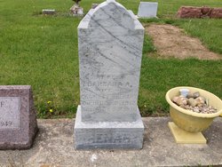
| Description | : | son of E(dgar) & C(atharine) Reiff He is the son of Enoch & Catharine - (bio says Edgar) The number of years are covered in the picture by the grass but birth year is from below. He is not on the 1870 census so he must die in the 1860s 1860 United States Federal Census Name: Amos Reiff Age: 4 Birth Year: abt 1856 Gender: Male Birth Place: Indiana Home in 1860: Preble, Adams, Indiana Post Office: Decatur Family Number: 344 Value of real estate: View image Household Members: Name Age Enoch Reiff 27 Catherine Reiff 23 Amos Reiff 4 William Reiff 2 Contributed by member: Explorer |
frequently asked questions (FAQ):
-
Where is Amos Reiff's memorial?
Amos Reiff's memorial is located at: All Saints Churchyard, Arksey, Metropolitan Borough of Doncaster, England.
-
When did Amos Reiff death?
Amos Reiff death on unknown in
-
Where are the coordinates of the Amos Reiff's memorial?
Latitude: 53.5557580
Longitude: -1.1271520
Family Members:
Parent

Siblings
Flowers:


Nearby Cemetories:
1. All Saints Churchyard
Arksey, Metropolitan Borough of Doncaster, England
Coordinate: 53.5557580, -1.1271520
2. Arksey Old Cemetery
Arksey, Metropolitan Borough of Doncaster, England
Coordinate: 53.5531600, -1.1312200
3. Arksey Cemetery
Arksey, Metropolitan Borough of Doncaster, England
Coordinate: 53.5522620, -1.1312680
4. Saint Oswald's Churchyard
Kirk Sandall, Metropolitan Borough of Doncaster, England
Coordinate: 53.5665233, -1.0806768
5. Friars Minor Greyfriars
Doncaster, Metropolitan Borough of Doncaster, England
Coordinate: 53.5263550, -1.1388230
6. St. George's Churchyard
Doncaster, Metropolitan Borough of Doncaster, England
Coordinate: 53.5233060, -1.1268600
7. Christ Church
Doncaster, Metropolitan Borough of Doncaster, England
Coordinate: 53.5231570, -1.1270320
8. Carmelite Friary Whitefriars
Doncaster, Metropolitan Borough of Doncaster, England
Coordinate: 53.5230210, -1.1346580
9. Quaker Burial Ground
Balby, Metropolitan Borough of Doncaster, England
Coordinate: 53.5215420, -1.1386660
10. St. Laurence Churchyard
Adwick le Street, Metropolitan Borough of Doncaster, England
Coordinate: 53.5710200, -1.1846150
11. Windmill Balk Lane Cemetery
Adwick le Street, Metropolitan Borough of Doncaster, England
Coordinate: 53.5662610, -1.1913080
12. Black Friars Friars Preachers
Doncaster, Metropolitan Borough of Doncaster, England
Coordinate: 53.5160000, -1.1330000
13. St Peter & St Paul's Churchyard
Barnby Dun, Metropolitan Borough of Doncaster, England
Coordinate: 53.5807905, -1.0737583
14. Hyde Park Cemetery
Doncaster, Metropolitan Borough of Doncaster, England
Coordinate: 53.5150570, -1.1316170
15. St. Leonard & St. Mary Churchyard
Armthorpe, Metropolitan Borough of Doncaster, England
Coordinate: 53.5368555, -1.0633563
16. All Saints Churchyard
Owston, Metropolitan Borough of Doncaster, England
Coordinate: 53.5942161, -1.1691935
17. Redhouse Lane Cemetery
Adwick le Street, Metropolitan Borough of Doncaster, England
Coordinate: 53.5762650, -1.1989510
18. Red House Cemetery
Brodsworth, Metropolitan Borough of Doncaster, England
Coordinate: 53.5761770, -1.1990350
19. Rose Hill Cemetery
Cantley, Metropolitan Borough of Doncaster, England
Coordinate: 53.5145880, -1.0863210
20. St John the Evangelist Churchyard
Balby, Metropolitan Borough of Doncaster, England
Coordinate: 53.5075700, -1.1506000
21. Balby War Memorial
Balby, Metropolitan Borough of Doncaster, England
Coordinate: 53.5072040, -1.1504580
22. Rose Hill Crematorium
Cantley, Metropolitan Borough of Doncaster, England
Coordinate: 53.5129200, -1.0813200
23. All Saints Church
Moss, Metropolitan Borough of Doncaster, England
Coordinate: 53.6079090, -1.1176700
24. Rands Lane Cemetery
Armthorpe, Metropolitan Borough of Doncaster, England
Coordinate: 53.5414848, -1.0403739