
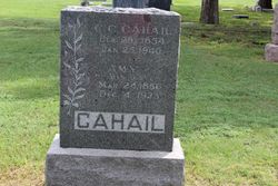
Amy Sumner Cahail
| Birth | : | 24 Mar 1856 Chelsea, Tama County, Iowa, USA |
| Death | : | 4 Dec 1923 Ogallah, Trego County, Kansas, USA |
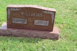
| Burial | : | Woodston Cemetery, Woodston, Rooks County, USA |
| Coordinate | : | 39.4375000, -99.1268997 |
| Description | : | "Amy Sumner was born in Chelsea, Tama County, Iowa, on March 24, 1856 and passed away on December 4, 1923, at her home in Ogallah, Kansas. She was married to Calvin C. Cahail at Chelsea, October 11, 1873, and came to Kansas in 1878, where they have since made their home. She is survived by her husband, Calvin C. Cahail, and eight children, Albert F., Mattie M., William, Elnora, Bertha, Cora, Nina and Jay; twenty-two grandchildren and two great-grandchildren; also two sisters, Mrs. Minerva Kinneman and Mrs. Minerva Cahail. One daughter preceded her to the Heavenly Home at the... Read More |
frequently asked questions (FAQ):
-
Where is Amy Sumner Cahail's memorial?
Amy Sumner Cahail's memorial is located at: Woodston Cemetery, Woodston, Rooks County, USA.
-
When did Amy Sumner Cahail death?
Amy Sumner Cahail death on 4 Dec 1923 in Ogallah, Trego County, Kansas, USA
-
Where are the coordinates of the Amy Sumner Cahail's memorial?
Latitude: 39.4375000
Longitude: -99.1268997
Family Members:
Parent
Spouse

Siblings

Children
Flowers:


Nearby Cemetories:
1. Woodston Cemetery
Woodston, Rooks County, USA
Coordinate: 39.4375000, -99.1268997
2. Survey Cemetery
Woodston, Rooks County, USA
Coordinate: 39.3722000, -99.1333008
3. Spring Branch Cemetery
Woodston, Rooks County, USA
Coordinate: 39.5099983, -99.0580978
4. West Hope Cemetery
Rooks County, USA
Coordinate: 39.5024986, -99.2110977
5. Ash Rock Cemetery
Woodston, Rooks County, USA
Coordinate: 39.5248909, -99.0817719
6. Pleasant Valley Cemetery
Osborne County, USA
Coordinate: 39.4583015, -99.0077972
7. Johnson Cemetery
Stockton, Rooks County, USA
Coordinate: 39.3493996, -99.1941986
8. Stockton Cemetery
Stockton, Rooks County, USA
Coordinate: 39.4406700, -99.2647400
9. Saint Thomas Cemetery
Stockton, Rooks County, USA
Coordinate: 39.4449997, -99.2771988
10. Chalk Mound Cemetery
Laton, Rooks County, USA
Coordinate: 39.3208008, -99.0852966
11. Pleasant Plain Cemetery
Osborne County, USA
Coordinate: 39.3367004, -99.0372009
12. Pioneer Cemetery
Alton, Osborne County, USA
Coordinate: 39.4742012, -98.9749985
13. Mount Ayr Cemetery
Alton, Osborne County, USA
Coordinate: 39.3764000, -98.9717026
14. Old Stockton Cemetery
Stockton, Rooks County, USA
Coordinate: 39.4597015, -99.3050003
15. Bigge Family Cemetery
Stockton, Rooks County, USA
Coordinate: 39.4584700, -99.3053200
16. Grant Center Cemetery
Alton, Osborne County, USA
Coordinate: 39.5242004, -98.9708023
17. Sumner Cemetery
Alton, Osborne County, USA
Coordinate: 39.4799995, -98.9338913
18. Pleasant Ridge Cemetery
Kirwin, Phillips County, USA
Coordinate: 39.5963000, -99.1234000
19. Aurora Cemetery
Laton, Rooks County, USA
Coordinate: 39.2778015, -99.0847015
20. Greenwood Cemetery
Kirwin, Phillips County, USA
Coordinate: 39.5931900, -99.2064600
21. Bow Creek Cemetery
Glade, Phillips County, USA
Coordinate: 39.5681000, -99.2696991
22. Twin Mound Cemetery
Rooks County, USA
Coordinate: 39.2855988, -99.2319031
23. Kill Creek Cemetery
Alton, Osborne County, USA
Coordinate: 39.3805528, -98.8967658
24. Leasburg Cemetery
Cedar, Smith County, USA
Coordinate: 39.5819016, -98.9728012