
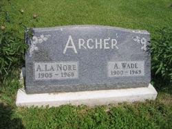
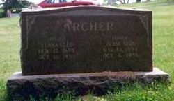
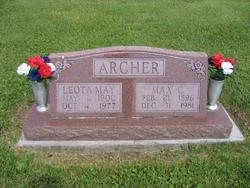
Ancil Wade Archer
| Birth | : | 30 Aug 1900 Davis County, Iowa, USA |
| Death | : | 1969 Davis County, Iowa, USA |
| Burial | : | St Austin's Churchyard, Grassendale, Metropolitan Borough of Liverpool, England |
| Coordinate | : | 53.3614552, -2.9124587 |
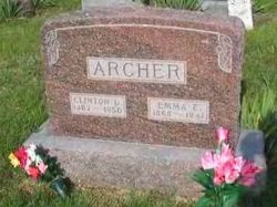
| Description | : | Son of Clinton Dewitt Archer and Emma Etta Ritz Archer. |
frequently asked questions (FAQ):
-
Where is Ancil Wade Archer's memorial?
Ancil Wade Archer's memorial is located at: St Austin's Churchyard, Grassendale, Metropolitan Borough of Liverpool, England.
-
When did Ancil Wade Archer death?
Ancil Wade Archer death on 1969 in Davis County, Iowa, USA
-
Where are the coordinates of the Ancil Wade Archer's memorial?
Latitude: 53.3614552
Longitude: -2.9124587
Family Members:
Parent

Spouse

Siblings


Children
Flowers:


Nearby Cemetories:
1. St Austin's Churchyard
Grassendale, Metropolitan Borough of Liverpool, England
Coordinate: 53.3614552, -2.9124587
2. Saint Michael's Church
Garston, Metropolitan Borough of Liverpool, England
Coordinate: 53.3518400, -2.8973800
3. St. Anne's Churchyard
Aigburth, Metropolitan Borough of Liverpool, England
Coordinate: 53.3695480, -2.9305760
4. St Matthew & St James Churchyard
Mossley Hill, Metropolitan Borough of Liverpool, England
Coordinate: 53.3764200, -2.9204740
5. Allerton Cemetery
Allerton, Metropolitan Borough of Liverpool, England
Coordinate: 53.3615646, -2.8844030
6. All Hallows Churchyard
Mossley Hill, Metropolitan Borough of Liverpool, England
Coordinate: 53.3808740, -2.9039930
7. Calderstones Park
Liverpool, Metropolitan Borough of Liverpool, England
Coordinate: 53.3817419, -2.8956218
8. St Michael's in the Hamlet
Aigburth, Metropolitan Borough of Liverpool, England
Coordinate: 53.3765870, -2.9499850
9. St. Mary's Churchyard
Woolton, Metropolitan Borough of Liverpool, England
Coordinate: 53.3750550, -2.8703760
10. St. Peter's Churchyard
Woolton, Metropolitan Borough of Liverpool, England
Coordinate: 53.3759310, -2.8693390
11. Holy Trinity Churchyard
Wavertree, Metropolitan Borough of Liverpool, England
Coordinate: 53.3946000, -2.9175700
12. Ancient Chapel Of Toxteth Park
Liverpool, Metropolitan Borough of Liverpool, England
Coordinate: 53.3811568, -2.9575849
13. Quaker Burial Ground
Liverpool, Metropolitan Borough of Liverpool, England
Coordinate: 53.3922330, -2.9348120
14. Hunter Street Burial Ground
Liverpool, Metropolitan Borough of Liverpool, England
Coordinate: 53.3922470, -2.9348630
15. All Saints Churchyard
Speke, Metropolitan Borough of Liverpool, England
Coordinate: 53.3439300, -2.8582400
16. Toxteth Park Cemetery
Toxteth, Metropolitan Borough of Liverpool, England
Coordinate: 53.3952960, -2.9396300
17. All Saints Churchyard
Childwall, Metropolitan Borough of Liverpool, England
Coordinate: 53.3952880, -2.8816030
18. Mayfields Woodland Remembrance Park
Eastham, Metropolitan Borough of Wirral, England
Coordinate: 53.3255100, -2.9550200
19. Wesleyan Methodist Chapel Graveyard
Liverpool, Metropolitan Borough of Liverpool, England
Coordinate: 53.3940590, -2.9719160
20. St Barnabas Bromborough
Bromborough, Metropolitan Borough of Wirral, England
Coordinate: 53.3324700, -2.9784000
21. St James Garden Cemetery
Liverpool, Metropolitan Borough of Liverpool, England
Coordinate: 53.3960744, -2.9715005
22. Broadgreen Jewish Cemetery
Liverpool, Metropolitan Borough of Liverpool, England
Coordinate: 53.4101320, -2.8977320
23. St. James Churchyard
Toxteth, Metropolitan Borough of Liverpool, England
Coordinate: 53.3943720, -2.9750688
24. Christ Church Churchyard
Port Sunlight, Metropolitan Borough of Wirral, England
Coordinate: 53.3534920, -2.9953750