
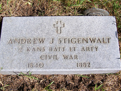
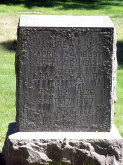
Andrew J Stigenwalt
| Birth | : | 24 Apr 1839 Fairfield County, Ohio, USA |
| Death | : | 30 Jun 1882 Lincoln County, Washington, USA |
| Burial | : | Turlock Memorial Park, Turlock, Stanislaus County, USA |
| Coordinate | : | 37.4937592, -120.8659821 |
| Description | : | ***************************** Military Inscription: ANDREW J STIGENWALT 2 KANSAS BATTERY LIGHT ARTILLERY CIVIL WAR ***************************** American Civil War Soldiers: Name: Andrew Stigenwalt Residence: Geneva, Kansas Enlistment Date: 8 Sep 1862 Side Served: Union State Served: Kansas Unit: 2nd Independent Battery, Kansas Light Artillery Service Record: Enlisted as a Private on 8 September 1862. Enlisted in 2nd Light Artillery Regiment Kansas on 10 Sep 1862. Mustered Out 2nd Light Artillery Regiment Kansas on 11 Aug 1865. Rank - In: Private Rank - Out: Private ***************************** 2nd Battery Light Artillery -- Organized at Fort Scott and mustered in September 10, 1862. Attached to Dept. of... Read More |
frequently asked questions (FAQ):
-
Where is Andrew J Stigenwalt's memorial?
Andrew J Stigenwalt's memorial is located at: Turlock Memorial Park, Turlock, Stanislaus County, USA.
-
When did Andrew J Stigenwalt death?
Andrew J Stigenwalt death on 30 Jun 1882 in Lincoln County, Washington, USA
-
Where are the coordinates of the Andrew J Stigenwalt's memorial?
Latitude: 37.4937592
Longitude: -120.8659821
Family Members:
Parent
Siblings

Flowers:


Nearby Cemetories:
1. Turlock Memorial Park
Turlock, Stanislaus County, USA
Coordinate: 37.4937592, -120.8659821
2. Saint Francis Episcopal Church Columbarium
Turlock, Stanislaus County, USA
Coordinate: 37.5014300, -120.8368400
3. Denair Cemetery
Denair, Stanislaus County, USA
Coordinate: 37.5293999, -120.8199997
4. North Hilmar Cemetery
Hilmar, Merced County, USA
Coordinate: 37.4146614, -120.8864288
5. South Hilmar Cemetery
Hilmar, Merced County, USA
Coordinate: 37.3802681, -120.8868408
6. Ceres Memorial Park
Ceres, Stanislaus County, USA
Coordinate: 37.5958214, -120.9634399
7. Lakewood Memorial Park
Hughson, Stanislaus County, USA
Coordinate: 37.6199760, -120.8975983
8. Colonel James J Stevinson Cemetery
Stevinson, Merced County, USA
Coordinate: 37.3572044, -120.9112320
9. Stevinson Sunnyside Cemetery
Stevinson, Merced County, USA
Coordinate: 37.3292007, -120.9231033
10. Saint Stanislaus Catholic Cemetery
Modesto, Stanislaus County, USA
Coordinate: 37.6473610, -120.9808440
11. Modesto Pioneer Cemetery
Modesto, Stanislaus County, USA
Coordinate: 37.6473350, -120.9829040
12. Modesto Citizens Cemetery
Modesto, Stanislaus County, USA
Coordinate: 37.6472930, -120.9845570
13. Acacia Memorial Park
Modesto, Stanislaus County, USA
Coordinate: 37.6481080, -120.9836610
14. Modesto County Cemetery
Modesto, Stanislaus County, USA
Coordinate: 37.6492400, -120.9813800
15. Martin Cemetery
Waterford, Stanislaus County, USA
Coordinate: 37.6684360, -120.7582160
16. Barfield Family Cemetery
Hopeton, Merced County, USA
Coordinate: 37.4675792, -120.6040085
17. Hills Ferry Cemetery
Newman, Stanislaus County, USA
Coordinate: 37.3321991, -121.0496979
18. Winton Cemetery
Winton, Merced County, USA
Coordinate: 37.3820267, -120.6260223
19. Roberts Ferry Cemetery
Waterford, Stanislaus County, USA
Coordinate: 37.6408005, -120.6288986
20. Patterson District Cemetery
Patterson, Stanislaus County, USA
Coordinate: 37.5268135, -121.1728287
21. Good Shepherd Catholic Cemetery
Modesto, Stanislaus County, USA
Coordinate: 37.6853130, -121.0672890
22. Wood Colony Cemetery
Salida, Stanislaus County, USA
Coordinate: 37.6893730, -121.0682144
23. Grayson Cemetery
Grayson, Stanislaus County, USA
Coordinate: 37.5594559, -121.1802826
24. Langworth Cemetery
Oakdale, Stanislaus County, USA
Coordinate: 37.7580986, -120.8957977