
Andrew Jackson Osborn
| Birth | : | 1815 Tennessee, USA |
| Death | : | 26 Dec 1864 Ozark County, Missouri, USA |
| Burial | : | Immanuel Lutheran Cemetery, Zeona, Perkins County, USA |
| Coordinate | : | 45.1937800, -102.9178200 |
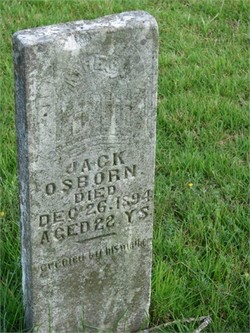
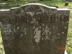
| Description | : | This tombstone is that of his son, I believe. Andrew J. Osborne was born about 1815 in Giles co. TN. He married second to julia Tutt 13 Feb 1844 in Peter Point, AR. He served as a private in Co B in the war with Mexico. Service terminated 1847. He joined Confederate until 1862. He was with his family and shot to death in Ozark, Missouri Aug 1864. |
frequently asked questions (FAQ):
-
Where is Andrew Jackson Osborn's memorial?
Andrew Jackson Osborn's memorial is located at: Immanuel Lutheran Cemetery, Zeona, Perkins County, USA.
-
When did Andrew Jackson Osborn death?
Andrew Jackson Osborn death on 26 Dec 1864 in Ozark County, Missouri, USA
-
Where are the coordinates of the Andrew Jackson Osborn's memorial?
Latitude: 45.1937800
Longitude: -102.9178200
Family Members:
Parent

Spouse
Children

Flowers:

Left by Anonymous on 05 Dec 2008

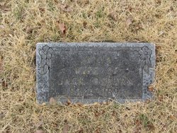
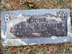
Husband of Julia FAUGHT
Left by Anonymous on 14 Jan 2013

Left by Anonymous on 26 Aug 2014

Left by Anonymous on 20 Feb 2015

??
Left by Anonymous on 20 Feb 2015
Left by Anonymous on 20 Feb 2015

Peace Grandpa.
Left by Anonymous on 04 Jun 2016

Left by Anonymous on 28 Feb 2018

Left by Anonymous on 16 Mar 2018

Claudia Hastings, do you know where Andrew Jackson Osborn was buried. I have found he was killed October 11, 18 October 11, 1864 in Ozark Missouri, where I live. Just curious if he was buried here in christian County. Shirley Methvin Watts
Left by Anonymous on 22 May 2019

Left by Anonymous on 28 Oct 2021


Nearby Cemetories:
1. Immanuel Lutheran Cemetery
Zeona, Perkins County, USA
Coordinate: 45.1937800, -102.9178200
2. Ruby Cemetery
Perkins County, USA
Coordinate: 45.2125015, -102.9067001
3. Mudd Butte Cemetery
Mud Butte, Meade County, USA
Coordinate: 44.9941100, -102.8607000
4. Ben Ash Cemetery
Maurine, Meade County, USA
Coordinate: 45.0221000, -102.7307900
5. Date Cemetery
Bison, Perkins County, USA
Coordinate: 45.3111000, -102.6311035
6. Hoover Cemetery
Butte County, USA
Coordinate: 45.1094900, -103.2791110
7. Plum Draw Cemetery
Meade County, USA
Coordinate: 44.9216995, -102.9578018
8. Sorenson Family Cemetery
Butte County, USA
Coordinate: 44.8766560, -102.9135050
9. Prairie City Cemetery
Prairie City, Perkins County, USA
Coordinate: 45.5307190, -102.8171290
10. Saint Anthony Cemetery
Butte County, USA
Coordinate: 45.1838989, -103.4263992
11. Slim Buttes Cemetery
Reva, Harding County, USA
Coordinate: 45.5452030, -103.0336800
12. Slim Buttes Battlefield Monument
Reva, Harding County, USA
Coordinate: 45.5434110, -103.1247460
13. Henry Bingaman Cemetery
Perkins County, USA
Coordinate: 45.5886002, -102.9499969
14. Opal Community Cemetery
Opal, Meade County, USA
Coordinate: 44.8922910, -102.5329490
15. Wakeman Cemetery
Redig, Harding County, USA
Coordinate: 45.2714005, -103.5014038
16. Backes Cemetery
Opal, Meade County, USA
Coordinate: 44.8999240, -102.4921240
17. South Grand River Cemetery
Perkins County, USA
Coordinate: 45.6321983, -102.9997025
18. Fairpoint Cemetery
Fairpoint, Meade County, USA
Coordinate: 44.7486000, -102.7855988
19. Scion Cemetery
Perkins County, USA
Coordinate: 45.6680984, -102.9068985
20. Bison Cemetery
Bison, Perkins County, USA
Coordinate: 45.5452995, -102.4563980
21. Chance Cemetery
Chance, Perkins County, USA
Coordinate: 45.4142530, -102.2728120
22. Saint Eulalia Cemetery
Harding County, USA
Coordinate: 45.7178001, -103.0635986
23. Fredlund Cemetery
Perkins County, USA
Coordinate: 45.7188988, -102.6585999
24. Holland Center Cemetery
Lodgepole, Perkins County, USA
Coordinate: 45.7347000, -102.7246400