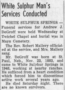
Andrew Jay DeGroff
| Birth | : | 23 Nov 1881 Nebraska, USA |
| Death | : | 21 May 1954 White Sulphur Springs, Meagher County, Montana, USA |
| Burial | : | Riverside Cemetery, Moline, Rock Island County, USA |
| Coordinate | : | 41.5078011, -90.4918976 |
| Plot | : | E687 |
frequently asked questions (FAQ):
-
Where is Andrew Jay DeGroff's memorial?
Andrew Jay DeGroff's memorial is located at: Riverside Cemetery, Moline, Rock Island County, USA.
-
When did Andrew Jay DeGroff death?
Andrew Jay DeGroff death on 21 May 1954 in White Sulphur Springs, Meagher County, Montana, USA
-
Where are the coordinates of the Andrew Jay DeGroff's memorial?
Latitude: 41.5078011
Longitude: -90.4918976
Family Members:
Parent
Siblings
Flowers:
Nearby Cemetories:
1. Riverside Cemetery
Moline, Rock Island County, USA
Coordinate: 41.5078011, -90.4918976
2. Rock Island National Cemetery
Rock Island, Rock Island County, USA
Coordinate: 41.5127983, -90.5235977
3. Saint Mary's Cemetery
East Moline, Rock Island County, USA
Coordinate: 41.5093994, -90.4569016
4. Regina Coeli Monastery Crypt (Defunct)
Bettendorf, Scott County, USA
Coordinate: 41.5308113, -90.5125351
5. South Moline Township Cemetery
Moline, Rock Island County, USA
Coordinate: 41.4770737, -90.4966125
6. Moline Memorial Park
Moline, Rock Island County, USA
Coordinate: 41.4807300, -90.4683400
7. Rock Island Confederate Cemetery
Rock Island, Rock Island County, USA
Coordinate: 41.5175018, -90.5338974
8. Rose Lawn Memorial Estate
Moline, Rock Island County, USA
Coordinate: 41.4742012, -90.4550018
9. Fenno Cemetery
Bettendorf, Scott County, USA
Coordinate: 41.5500336, -90.4579086
10. Campbell's Island State Historic Site
East Moline, Rock Island County, USA
Coordinate: 41.5383339, -90.4366302
11. Hebrew Cemetery
Rock Island, Rock Island County, USA
Coordinate: 41.4818993, -90.5543976
12. William Carr Cemetery
Rock Island, Rock Island County, USA
Coordinate: 41.4691010, -90.5426025
13. Fort Armstrong Post Cemetery
Rock Island, Rock Island County, USA
Coordinate: 41.5147057, -90.5637665
14. Oakdale Memorial Gardens
Davenport, Scott County, USA
Coordinate: 41.5449210, -90.5513270
15. Immanuel Lutheran Cemetery
Rock Island, Rock Island County, USA
Coordinate: 41.4858017, -90.5646973
16. Love of Animals Petland Cemetery
Davenport, Scott County, USA
Coordinate: 41.5481400, -90.5491800
17. Le Claire Cemetery (Defunct)
Davenport, Scott County, USA
Coordinate: 41.5259050, -90.5685600
18. Rock Island Memorial Park Cemetery
Rock Island, Rock Island County, USA
Coordinate: 41.4685900, -90.5553700
19. Sacred Heart Cathedral Memorial
Davenport, Scott County, USA
Coordinate: 41.5299911, -90.5692520
20. Palmer College of Chiropractic Heritage Wall
Davenport, Scott County, USA
Coordinate: 41.5294762, -90.5748596
21. Le Claire Park
Davenport, Scott County, USA
Coordinate: 41.5188446, -90.5788727
22. Rock Island County Justice Center Grounds
Rock Island, Rock Island County, USA
Coordinate: 41.5091324, -90.5802917
23. Greenview Memorial Gardens
East Moline, Rock Island County, USA
Coordinate: 41.4841000, -90.4091440
24. Trinity Episcopal Cathedral Columbarium
Davenport, Scott County, USA
Coordinate: 41.5316230, -90.5748420


