
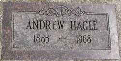
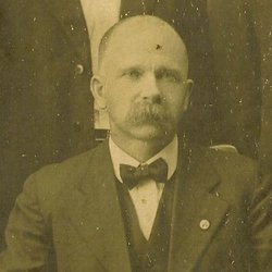
Andrew John Hagle
| Birth | : | 23 Apr 1883 Fertile, Polk County, Minnesota, USA |
| Death | : | 29 Oct 1968 Cooperstown, Griggs County, North Dakota, USA |
| Burial | : | Pioneer Memorial Park, Bluewater, Cibola County, USA |
| Coordinate | : | 35.2430992, -107.9685974 |
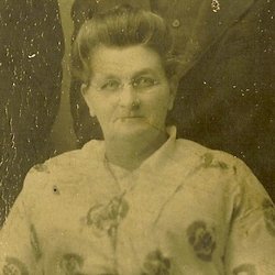
| Description | : | Funeral Today at 2 For Andrew Hagle Andrew Hagle, 85, died Tuesday in the hospital here. The funeral is at 2 this (Thursday) afternoon in Grace Lutheran church. Mr. Hagle was born at Fertile, Minn., April 23, 1883, the son of Mr. and Mrs. Mons Hagle. The family moved to this community when he was a young boy. They farmed first in Sverdrup township and later near Binford. He farmed until moving to Cooperstown, where he was employed at the Cussons seed house for many years. He leaves his second wife, the former... Read More |
frequently asked questions (FAQ):
-
Where is Andrew John Hagle's memorial?
Andrew John Hagle's memorial is located at: Pioneer Memorial Park, Bluewater, Cibola County, USA.
-
When did Andrew John Hagle death?
Andrew John Hagle death on 29 Oct 1968 in Cooperstown, Griggs County, North Dakota, USA
-
Where are the coordinates of the Andrew John Hagle's memorial?
Latitude: 35.2430992
Longitude: -107.9685974
Family Members:
Parent
Spouse
Siblings
Children

Flowers:


Nearby Cemetories:
1. Pioneer Memorial Park
Bluewater, Cibola County, USA
Coordinate: 35.2430992, -107.9685974
2. Grants Memorial Park
Grants, Cibola County, USA
Coordinate: 35.1605500, -107.8365000
3. La Morada Cemetery
San Rafael, Cibola County, USA
Coordinate: 35.1125000, -107.8854000
4. San Rafael Cemetery
San Rafael, Cibola County, USA
Coordinate: 35.1093170, -107.8850430
5. Porter Cemetery
Cibola County, USA
Coordinate: 35.1018982, -107.8852997
6. Thoreau Cemetery
Thoreau, McKinley County, USA
Coordinate: 35.4082450, -108.2066630
7. San Mateo Cemetery
San Mateo, Cibola County, USA
Coordinate: 35.3310570, -107.6425840
8. Tinaja Cemetery
Tinaja, Cibola County, USA
Coordinate: 35.0904800, -108.2688900
9. McCartys Cemetery
McCartys, Cibola County, USA
Coordinate: 35.0611430, -107.6716590
10. Borrego Pass Cemetery
McKinley County, USA
Coordinate: 35.5711550, -108.0172970
11. San Fidel Cemetery
San Fidel, Cibola County, USA
Coordinate: 35.0821991, -107.5986023
12. Ethridge Family Cemetery
San Fidel, Cibola County, USA
Coordinate: 35.0827655, -107.5982033
13. Acomita Cemetery
Acomita, Cibola County, USA
Coordinate: 35.0507590, -107.5950070
14. El Morro Cemetery
Cibola County, USA
Coordinate: 35.0170000, -108.3470000
15. Budville Cemetery
Cibola County, USA
Coordinate: 35.0785000, -107.5242000
16. New York Cemetery
New York, Cibola County, USA
Coordinate: 35.0575000, -107.5333000
17. Laguna-Acoma Baptist Indian Mission Cemetery
Cubero, Cibola County, USA
Coordinate: 35.0670731, -107.5255031
18. Cubero Cemetery
Cubero, Cibola County, USA
Coordinate: 35.0786000, -107.5093000
19. Mormon Colony Cemetery
Cibola County, USA
Coordinate: 35.1730995, -108.4661026
20. Seama Village Cemetery
Seama, Cibola County, USA
Coordinate: 35.0367630, -107.5255470
21. Ramah Cemetery
Ramah, McKinley County, USA
Coordinate: 35.1258011, -108.4950027
22. Paraje Cemetery
Paraje, Cibola County, USA
Coordinate: 35.0456009, -107.4708023
23. Crownpoint Cemetery
Crownpoint, McKinley County, USA
Coordinate: 35.6757630, -108.1533320
24. Casa Blanca Cemetery
Casa Blanca, Cibola County, USA
Coordinate: 35.0416000, -107.4616000