

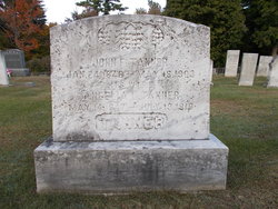
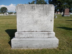
Angelia L. Rand Tanner
| Birth | : | 14 May 1847 |
| Death | : | 19 Jul 1919 |
| Burial | : | Pine Grove Cemetery, Farmington, Strafford County, USA |
| Coordinate | : | 43.3852800, -71.0583300 |
| Description | : | 1880 United States Federal Census Name Angelia L. Tanner Age 31 Birth Year abt 1849 Birthplace New Hampshire Home in 1880 Farmington, Strafford, New Hampshire Gender Female Relation to Head of House Wife Marital Status Married Spouse's Name John F. Tanner Father's Birthplace New Hampshire Mother's Birthplace New Hampshire Name Age John F. Tanner 34 Angelia L. Tanner 31 Hellen L. Tanner 13 Ada R. Tanner 4 John C. Tanner 2 New Hampshire, Death and Disinterment Records, 1754-1947 Name Angelia Tanner Gender Female Birth Date abt 1847 Birth Place Durham, New Hampshire Father Ezra Rand Death Date 19 Jul 1919 Death Place... Read More |
frequently asked questions (FAQ):
-
Where is Angelia L. Rand Tanner's memorial?
Angelia L. Rand Tanner's memorial is located at: Pine Grove Cemetery, Farmington, Strafford County, USA.
-
When did Angelia L. Rand Tanner death?
Angelia L. Rand Tanner death on 19 Jul 1919 in
-
Where are the coordinates of the Angelia L. Rand Tanner's memorial?
Latitude: 43.3852800
Longitude: -71.0583300
Family Members:
Spouse
Children

Flowers:


Nearby Cemetories:
1. Pine Grove Cemetery
Farmington, Strafford County, USA
Coordinate: 43.3852800, -71.0583300
2. French Family Graveyard
Farmington, Strafford County, USA
Coordinate: 43.3841670, -71.0530560
3. Colbath Cemetery
Farmington, Strafford County, USA
Coordinate: 43.3825000, -71.0508330
4. Hayes Cemetery
Farmington, Strafford County, USA
Coordinate: 43.3846217, -71.0394091
5. Hayes Cemetery
Farmington, Strafford County, USA
Coordinate: 43.3840653, -71.0358553
6. Tanner Cemetery
Farmington, Strafford County, USA
Coordinate: 43.3711780, -71.0453440
7. Waldron Cemetery
Farmington, Strafford County, USA
Coordinate: 43.4031260, -71.0805160
8. Dame Burial Ground
Farmington, Strafford County, USA
Coordinate: 43.3575620, -71.0777570
9. Bennet Cemetery
Farmington, Strafford County, USA
Coordinate: 43.3809950, -71.1010310
10. Hayes Cemetery
Milton, Strafford County, USA
Coordinate: 43.4078500, -71.0269330
11. Colbath Farm Cemetery
Farmington, Strafford County, USA
Coordinate: 43.3602780, -71.0866670
12. Nute-Varney Cemetery
Milton, Strafford County, USA
Coordinate: 43.4030039, -71.0202944
13. Leighton Cemetery
Farmington, Strafford County, USA
Coordinate: 43.4183130, -71.0757490
14. Richard Plumer Cemetery
Milton, Strafford County, USA
Coordinate: 43.4188890, -71.0419440
15. Jones Family Cemetery
Farmington, Strafford County, USA
Coordinate: 43.3551700, -71.0284000
16. Pearl Cemetery
Strafford County, USA
Coordinate: 43.3929100, -71.1087200
17. John Plumer Cemetery
Milton, Strafford County, USA
Coordinate: 43.4222170, -71.0468570
18. Pinkham Cemetery
Farmington, Strafford County, USA
Coordinate: 43.4204630, -71.0784750
19. Bessie Plumer Grave
Milton, Strafford County, USA
Coordinate: 43.4232920, -71.0487340
20. Place Cemetery
Farmington, Strafford County, USA
Coordinate: 43.3538350, -71.0272810
21. Chesley-Twombly Cemetery
Farmington, Strafford County, USA
Coordinate: 43.3467590, -71.0643760
22. Wentworth Cemetery
Milton, Strafford County, USA
Coordinate: 43.4247220, -71.0544440
23. Walker Cemetery
Farmington, Strafford County, USA
Coordinate: 43.3499580, -71.0258770
24. Cook-Downing Cemetery
Milton, Strafford County, USA
Coordinate: 43.4298090, -71.0636960