
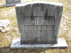
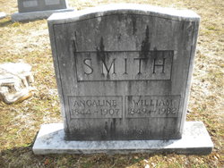
Angeline A. Howell Smith
| Birth | : | 11 Jan 1844 Oregon County, Missouri, USA |
| Death | : | 15 Apr 1907 Howell County, Missouri, USA |
| Burial | : | Clifton Cemetery, Clifton, Oregon County, USA |
| Coordinate | : | 36.5511017, -91.5350037 |
| Description | : | Daughter of Thomas Jefferson Howell and Emiline Campbell Married William Smith on 11 Apr 1869 in Oregon Co., Missouri Mother of Loranza B., Thomas, Nancy, Emeline, Rosella and Augustus Smith |
frequently asked questions (FAQ):
-
Where is Angeline A. Howell Smith's memorial?
Angeline A. Howell Smith's memorial is located at: Clifton Cemetery, Clifton, Oregon County, USA.
-
When did Angeline A. Howell Smith death?
Angeline A. Howell Smith death on 15 Apr 1907 in Howell County, Missouri, USA
-
Where are the coordinates of the Angeline A. Howell Smith's memorial?
Latitude: 36.5511017
Longitude: -91.5350037
Family Members:
Parent
Spouse
Siblings
Children
Flowers:


Nearby Cemetories:
1. Clifton Cemetery
Clifton, Oregon County, USA
Coordinate: 36.5511017, -91.5350037
2. Old George Martin Farm Cemetery
Allen Ford, Oregon County, USA
Coordinate: 36.5374850, -91.5230010
3. Clifton Cemetery
Sloan Ford, Oregon County, USA
Coordinate: 36.5677900, -91.5329000
4. Bledsaw Cemetery
Thayer, Oregon County, USA
Coordinate: 36.5595741, -91.5537949
5. N B Allen Ford
Allen Ford, Oregon County, USA
Coordinate: 36.5411700, -91.5172900
6. Brenner Farm Cemetery
Allen Ford, Oregon County, USA
Coordinate: 36.5477000, -91.5065400
7. Ragan Cemetery
Thayer, Oregon County, USA
Coordinate: 36.5235863, -91.5213242
8. Roth Cemetery
Sloan Ford, Oregon County, USA
Coordinate: 36.5808945, -91.5498657
9. Two Mile Cemetery
Thayer, Oregon County, USA
Coordinate: 36.5485700, -91.5748800
10. Dode Jones Farm Cemetery
Sloan Ford, Oregon County, USA
Coordinate: 36.5804900, -91.5568800
11. Willard Dode Jones Farm Cemetery
Thayer, Oregon County, USA
Coordinate: 36.5808300, -91.5572300
12. Sergeant-Mount Olive Cemetery
Thayer, Oregon County, USA
Coordinate: 36.5634390, -91.5755830
13. Thayer Cemetery
Thayer, Oregon County, USA
Coordinate: 36.5152200, -91.5395100
14. Crazy Spring
Thayer, Oregon County, USA
Coordinate: 36.5818700, -91.5624100
15. Lindley Cemetery
Clifton, Oregon County, USA
Coordinate: 36.5820400, -91.5036200
16. Buehler Farm Cemetery
Clifton, Oregon County, USA
Coordinate: 36.5639496, -91.4845810
17. Warren Coats Farm Cemetery
Sloan Ford, Oregon County, USA
Coordinate: 36.5986700, -91.5438800
18. Davis Cemetery
Thayer, Oregon County, USA
Coordinate: 36.5339508, -91.4751358
19. Old Town Church of God
Old Town, Oregon County, USA
Coordinate: 36.5004900, -91.5451800
20. Spring City Cemetery
Mammoth Spring, Fulton County, USA
Coordinate: 36.4983360, -91.5308040
21. Spring City Cemetery #2
Mammoth Spring, Fulton County, USA
Coordinate: 36.4982800, -91.5299400
22. Union Hill Cemetery
Brandsville, Howell County, USA
Coordinate: 36.5256341, -91.4746829
23. Jeff Cemetery
Jeff, Oregon County, USA
Coordinate: 36.5256166, -91.4746129
24. Walker Cemetery
Thayer, Oregon County, USA
Coordinate: 36.5985985, -91.5697021