


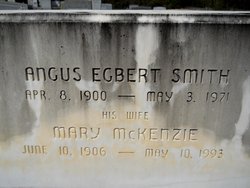
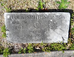
Angus Egbert Smith
| Birth | : | 8 Apr 1900 South Carolina, USA |
| Death | : | 3 May 1971 Laurinburg, Scotland County, North Carolina, USA |
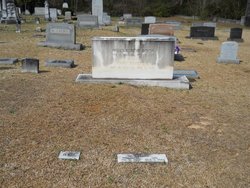
| Burial | : | Carolina Presbyterian Church Cemetery, Carolina, Dillon County, USA |
| Coordinate | : | 34.5736008, -79.4385986 |
| Description | : | Husband of Mary McKenzie. |
frequently asked questions (FAQ):
-
Where is Angus Egbert Smith's memorial?
Angus Egbert Smith's memorial is located at: Carolina Presbyterian Church Cemetery, Carolina, Dillon County, USA.
-
When did Angus Egbert Smith death?
Angus Egbert Smith death on 3 May 1971 in Laurinburg, Scotland County, North Carolina, USA
-
Where are the coordinates of the Angus Egbert Smith's memorial?
Latitude: 34.5736008
Longitude: -79.4385986
Family Members:
Parent

Spouse
Siblings


Children

Flowers:


Nearby Cemetories:
1. Carolina Presbyterian Church Cemetery
Carolina, Dillon County, USA
Coordinate: 34.5736008, -79.4385986
2. Leland Grove Church Cemetery
Carolina, Dillon County, USA
Coordinate: 34.5841217, -79.4222107
3. New Holly United Methodist Church Cemetery
Little Rock, Dillon County, USA
Coordinate: 34.5512800, -79.4540800
4. Fairview United Methodist Church Cemetery
Hamer, Dillon County, USA
Coordinate: 34.5679970, -79.4032593
5. Billy Bethea Family Cemetery
Hamer, Dillon County, USA
Coordinate: 34.5585175, -79.4048538
6. New Zion AME Zion Church Cemetery
Judson, Dillon County, USA
Coordinate: 34.5578930, -79.4766430
7. Hunt Family Cemetery
Hamer, Dillon County, USA
Coordinate: 34.5562700, -79.4013700
8. Pee Dee Chapel Baptist Church Cemetery
Carolina, Dillon County, USA
Coordinate: 34.6074638, -79.4516678
9. Sinclair Cemetery
Sinclair Crossroads, Dillon County, USA
Coordinate: 34.5240860, -79.4622574
10. Ivey Cemetery
Tatum, Marlboro County, USA
Coordinate: 34.5985550, -79.4979030
11. Old Reedy Branch Cemetery
Clio, Marlboro County, USA
Coordinate: 34.6160300, -79.4836400
12. Reedy Branch Baptist Church
Marlboro County, USA
Coordinate: 34.6254900, -79.4757300
13. Magnolia Stateline AME Church Cemetery
Hamer, Dillon County, USA
Coordinate: 34.5445200, -79.3690400
14. Hairgrove Cemetery
Minturn, Dillon County, USA
Coordinate: 34.5107307, -79.4568176
15. John W. Stackhouse Memorial
Galavon, Dillon County, USA
Coordinate: 34.5097970, -79.4542730
16. Baker Cemetery
Dillon County, USA
Coordinate: 34.5483017, -79.3636017
17. Britt-Brock Cemetery
Clio, Marlboro County, USA
Coordinate: 34.6121670, -79.5049090
18. Red Bluff Cemetery
Clio, Marlboro County, USA
Coordinate: 34.6117783, -79.5053711
19. Daniels Chapel Cemetery
Marlboro County, USA
Coordinate: 34.6192000, -79.4993600
20. Ivy Cemetery
Clio, Marlboro County, USA
Coordinate: 34.5742530, -79.5220290
21. Oakland United Methodist Church Cemetery
Oakland Crossroads, Dillon County, USA
Coordinate: 34.5393829, -79.3651962
22. Saint Luke United Methodist Church Cemetery
Hamer, Dillon County, USA
Coordinate: 34.5263900, -79.3757200
23. Sweat Swamp Cemetery
Dillon County, USA
Coordinate: 34.5056000, -79.4122009
24. Ebenezer Memorial Garden
Marlboro County, USA
Coordinate: 34.5456009, -79.5188980