
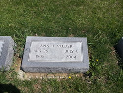
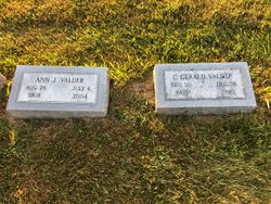
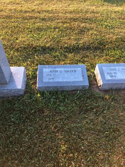
Ann Josephine Sedlacek Valder
| Birth | : | 26 Aug 1908 Blue Rapids, Marshall County, Kansas, USA |
| Death | : | 6 Jul 2004 Garden Grove, Orange County, California, USA |
| Burial | : | Vail Cemetery, Vail, Crawford County, USA |
| Coordinate | : | 42.0647011, -95.2102966 |
| Plot | : | Block 11 Lot 102 |
| Description | : | Moved from Kansas to Pender, NE when she was about 6 years old. Graduated from Pender High School, attended Wayne State College and the University of Nebraska. Taught country school until her marriage to C. Gerald Valder April 20, 1935. Had one son, John, the following year. Lived with husband and son on her husband's father's farm near Tekamah, Ne until 1943; then, purchased a farm with her husband near Lyons, NE where they lived until 1956 when she and her husband moved to Omaha, NE. There, she worked as a secretary until her retirement.... Read More |
frequently asked questions (FAQ):
-
Where is Ann Josephine Sedlacek Valder's memorial?
Ann Josephine Sedlacek Valder's memorial is located at: Vail Cemetery, Vail, Crawford County, USA.
-
When did Ann Josephine Sedlacek Valder death?
Ann Josephine Sedlacek Valder death on 6 Jul 2004 in Garden Grove, Orange County, California, USA
-
Where are the coordinates of the Ann Josephine Sedlacek Valder's memorial?
Latitude: 42.0647011
Longitude: -95.2102966
Family Members:
Parent
Spouse
Siblings
Children
Flowers:


Nearby Cemetories:
1. Vail Cemetery
Vail, Crawford County, USA
Coordinate: 42.0647011, -95.2102966
2. Saint Anns Cemetery
Vail, Crawford County, USA
Coordinate: 42.0513992, -95.1868973
3. King Cemetery
Vail, Crawford County, USA
Coordinate: 42.1007996, -95.2319031
4. Hayes Township Cemetery
Westside, Crawford County, USA
Coordinate: 42.0083199, -95.1216583
5. Westside Cemetery
Westside, Crawford County, USA
Coordinate: 42.0602989, -95.0922012
6. Deloit Cemetery
Deloit, Crawford County, USA
Coordinate: 42.1075325, -95.3136520
7. Old Catholic Cemetery
Denison, Crawford County, USA
Coordinate: 42.0043983, -95.3189011
8. Saint Rose of Lima Cemetery
Denison, Crawford County, USA
Coordinate: 42.0247002, -95.3394012
9. Crawford Heights Memory Gardens
Denison, Crawford County, USA
Coordinate: 42.0008011, -95.3469009
10. Saint John Lutheran Church Cemetery
Crawford County, USA
Coordinate: 42.1780000, -95.2650000
11. Zion Lutheran Cemetery
Denison, Crawford County, USA
Coordinate: 41.9958000, -95.3450012
12. Oakland Cemetery
Denison, Crawford County, USA
Coordinate: 41.9972000, -95.3478012
13. Saint Johns Catholic Cemetery
Arcadia, Carroll County, USA
Coordinate: 42.0855406, -95.0341577
14. Kiron Cemetery
Kiron, Crawford County, USA
Coordinate: 42.1817017, -95.3133011
15. Lehfeldt Cemetery
Kiron, Crawford County, USA
Coordinate: 42.1458170, -95.3724972
16. Arcadia Cemetery
Arcadia Township, Carroll County, USA
Coordinate: 42.1000680, -95.0130550
17. Nishnabotna Cemetery
Manilla, Crawford County, USA
Coordinate: 41.9086952, -95.2464447
18. Washington Township Cemetery
Buck Grove, Crawford County, USA
Coordinate: 41.9354000, -95.3387000
19. Iowa Township Cemetery
Aspinwall, Crawford County, USA
Coordinate: 41.9216995, -95.1113968
20. Wheatland Cemetery
Carroll County, USA
Coordinate: 42.1814003, -95.0582962
21. Bethel Cemetery
Kiron, Crawford County, USA
Coordinate: 42.2192001, -95.3043976
22. Mount Olivet Cemetery
Manilla, Crawford County, USA
Coordinate: 41.8922005, -95.2200012
23. Saint Augustine Cemetery
Halbur, Carroll County, USA
Coordinate: 42.0066986, -94.9744034
24. Morgan Cemetery
Schleswig, Crawford County, USA
Coordinate: 42.1394005, -95.4403000