
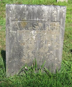
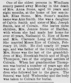
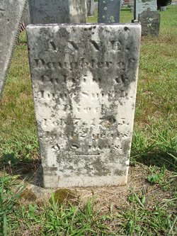
Ann T Smith Stone
| Birth | : | 19 Feb 1798 Colrain, Franklin County, Massachusetts, USA |
| Death | : | 27 Sep 1896 |
| Burial | : | Colrain West Branch Cemetery, Colrain, Franklin County, USA |
| Coordinate | : | 42.6671982, -72.7221985 |
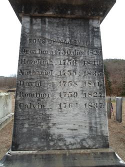
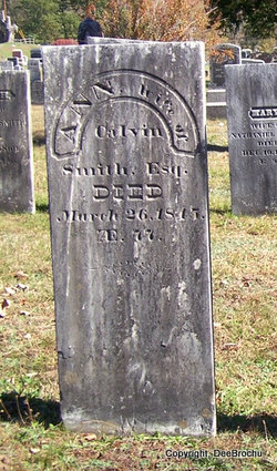
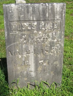
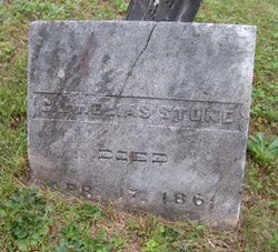
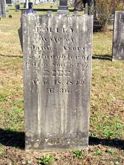
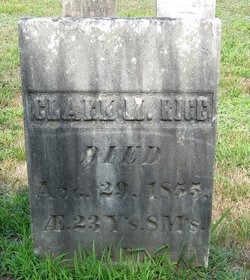
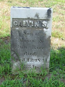
| Description | : | She married, first, at Colrain,MA on Feb 19,1829, Moses Rice. She married, second, on Nov 23,1854 at Colrain,MA, Elias Stone III of Halifax,VT. She was living in Halifax,VT in 1880 in the household of her step-son Elias Stone IV. Children(by first marriage): Prudence Barnard Rice(here? - is she the Prudence Rice who married William Niles?), Moses Clark Rice, an infant daughter, Nathaniel S Rice(father of Hattie M Rice and Delia E Rice), Calvin S Rice, and Mary Emeline Rice Long. |
frequently asked questions (FAQ):
-
Where is Ann T Smith Stone's memorial?
Ann T Smith Stone's memorial is located at: Colrain West Branch Cemetery, Colrain, Franklin County, USA.
-
When did Ann T Smith Stone death?
Ann T Smith Stone death on 27 Sep 1896 in
-
Where are the coordinates of the Ann T Smith Stone's memorial?
Latitude: 42.6671982
Longitude: -72.7221985
Family Members:
Parent
Spouse
Siblings
Children
Flowers:


Nearby Cemetories:
1. Colrain West Branch Cemetery
Colrain, Franklin County, USA
Coordinate: 42.6671982, -72.7221985
2. Chandler Hill Cemetery
Colrain, Franklin County, USA
Coordinate: 42.6683006, -72.6832962
3. North River Cemetery
Colrain, Franklin County, USA
Coordinate: 42.6856003, -72.6917038
4. Brick School Cemetery
Colrain, Franklin County, USA
Coordinate: 42.6641998, -72.6660995
5. Arms Cemetery
Shelburne Falls, Franklin County, USA
Coordinate: 42.6166992, -72.7332993
6. Christian Hill Cemetery
Colrain, Franklin County, USA
Coordinate: 42.7158012, -72.7643967
7. West Leyden Cemetery
Leyden, Franklin County, USA
Coordinate: 42.7061005, -72.6572037
8. East Shelburne Cemetery
Shelburne, Franklin County, USA
Coordinate: 42.6105995, -72.6694031
9. South Leyden Cemetery
Leyden, Franklin County, USA
Coordinate: 42.6831400, -72.6311200
10. East Charlemont Cemetery
Charlemont, Franklin County, USA
Coordinate: 42.6197853, -72.7932739
11. Center Cemetery
Heath, Franklin County, USA
Coordinate: 42.6819000, -72.8167038
12. Henry Farm Cemetery
West Halifax, Windham County, USA
Coordinate: 42.7379712, -72.7132938
13. Brown Cemetery
West Dummerston, Windham County, USA
Coordinate: 42.7392340, -72.7135850
14. Hill Cemetery
Shelburne, Franklin County, USA
Coordinate: 42.5984344, -72.6878815
15. East Buckland Cemetery
Buckland, Franklin County, USA
Coordinate: 42.5962500, -72.7610600
16. Bell Cemetery
Halifax, Windham County, USA
Coordinate: 42.7423800, -72.6972900
17. Old East Buckland Cemetery
Buckland, Franklin County, USA
Coordinate: 42.5969400, -72.7677900
18. Stark Cemetery
Guilford, Windham County, USA
Coordinate: 42.7402992, -72.6746979
19. Clark Family Cemetery
Halifax, Windham County, USA
Coordinate: 42.7479180, -72.7103090
20. South Cemetery
Heath, Franklin County, USA
Coordinate: 42.6542015, -72.8321991
21. North Meadows Cemetery
Greenfield, Franklin County, USA
Coordinate: 42.6171989, -72.6333008
22. Country Farms Cemetery
Greenfield, Franklin County, USA
Coordinate: 42.6393900, -72.6165400
23. Pennel Hill Cemetery
Halifax, Windham County, USA
Coordinate: 42.7364006, -72.7857971
24. Shelburne Center Cemetery
Shelburne, Franklin County, USA
Coordinate: 42.5830000, -72.6969600