

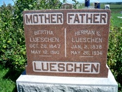
Anna Catharine Bertha “Bertha” Spanhake Lueschen
| Birth | : | 28 Oct 1847 Grossenkneten, Landkreis Oldenburg, Lower Saxony (Niedersachsen), Germany |
| Death | : | 12 May 1910 Platte County, Nebraska, USA |
| Burial | : | McComb Union Cemetery, McComb, Hancock County, USA |
| Coordinate | : | 41.1072731, -83.8018799 |
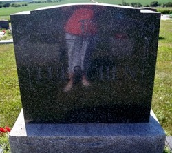
| Description | : | row 17 Döhlen, Oldenburg, Niedersachsen, Germany LUESCHEN, BERTHA (October 28, 1847 - May 12, 1910) - [The Columbus Journal, May 18, 1910, pg. 5, col. 3] Following a stroke of paralysis, Mrs. Herman Lueschen passed away at her home nine miles southwest of town, early Tuesday morning. Mrs. Lueschen arose as usual, at about five o'clock, but complained of a severe headache. She grew worse and a stroke of paralysis followed, death relieving her of her suffering within an hour. In 1869 Mr. and Mrs. Lueschen came to Nebraska and settled upon the homestead nine miles south... Read More |
frequently asked questions (FAQ):
-
Where is Anna Catharine Bertha “Bertha” Spanhake Lueschen's memorial?
Anna Catharine Bertha “Bertha” Spanhake Lueschen's memorial is located at: McComb Union Cemetery, McComb, Hancock County, USA.
-
When did Anna Catharine Bertha “Bertha” Spanhake Lueschen death?
Anna Catharine Bertha “Bertha” Spanhake Lueschen death on 12 May 1910 in Platte County, Nebraska, USA
-
Where are the coordinates of the Anna Catharine Bertha “Bertha” Spanhake Lueschen's memorial?
Latitude: 41.1072731
Longitude: -83.8018799
Family Members:
Spouse
Children
Flowers:


Nearby Cemetories:
1. McComb Union Cemetery
McComb, Hancock County, USA
Coordinate: 41.1072731, -83.8018799
2. Horn Family Cemetery
McComb, Hancock County, USA
Coordinate: 41.0808151, -83.8421077
3. Thomas Cemetery
Hancock County, USA
Coordinate: 41.1483002, -83.7556000
4. Indian Green Cemetery
Findlay, Hancock County, USA
Coordinate: 41.0616989, -83.7553024
5. Dukes Cemetery
Benton Ridge, Hancock County, USA
Coordinate: 41.0511017, -83.8230972
6. Schwartz Cemetery
Benton Ridge, Hancock County, USA
Coordinate: 41.0438995, -83.7822037
7. Pleasant Hill Cemetery
McComb, Hancock County, USA
Coordinate: 41.1236000, -83.7027969
8. Colclo Cemetery
McComb, Hancock County, USA
Coordinate: 41.0384650, -83.8661150
9. Bethel Cemetery
Hancock County, USA
Coordinate: 41.1622009, -83.7086029
10. Jackson Township Cemetery
Jackson Township, Wood County, USA
Coordinate: 41.1822700, -83.8660500
11. Aurand Cemetery
Benton Ridge, Hancock County, USA
Coordinate: 41.0297012, -83.7146988
12. Hancock County Infirmary Cemetery
Findlay, Hancock County, USA
Coordinate: 41.0511643, -83.6888223
13. Fairchild Cemetery
Blanchard Township, Putnam County, USA
Coordinate: 41.0245700, -83.8819900
14. East Belmore Cemetery
Belmore, Putnam County, USA
Coordinate: 41.1464005, -83.9278030
15. Benton Ridge Cemetery
Benton Ridge, Hancock County, USA
Coordinate: 41.0036659, -83.7999344
16. Hedges Cemetery
Findlay, Hancock County, USA
Coordinate: 41.0582397, -83.6793197
17. Knepper Cemetery
Benton Ridge, Hancock County, USA
Coordinate: 41.0033950, -83.7780300
18. New Maplewood Cemetery
North Baltimore, Wood County, USA
Coordinate: 41.1711006, -83.6889038
19. Old Maplewood Cemetery
North Baltimore, Wood County, USA
Coordinate: 41.1730170, -83.6734200
20. Radar Cemetery (Defunct)
Van Buren, Hancock County, USA
Coordinate: 41.1314498, -83.6498657
21. Tawa Cemetery
Benton Ridge, Hancock County, USA
Coordinate: 40.9887750, -83.7880040
22. Maple Grove Cemetery
Findlay, Hancock County, USA
Coordinate: 41.0414350, -83.6680450
23. Saint Michaels Catholic Cemetery
Findlay, Hancock County, USA
Coordinate: 41.0433006, -83.6641998
24. Hough Cemetery
North Baltimore, Wood County, USA
Coordinate: 41.1903300, -83.6810400