
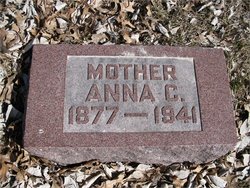


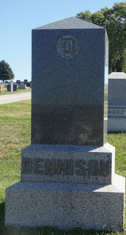
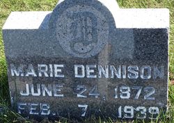
Anna Chisholm Dennison Lutz
| Birth | : | 13 Apr 1877 Mariaville, Schenectady County, New York, USA |
| Death | : | Mar 1941 McCook, Red Willow County, Nebraska, USA |
| Burial | : | Kinkead Cemetery, Alexandria, Douglas County, USA |
| Coordinate | : | 45.8989000, -95.3913900 |
| Plot | : | Lot 111 N 4 |
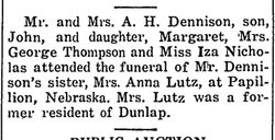
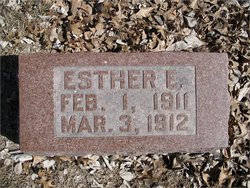
| Description | : | Anna married John Jacob Lutz on June 23, 1909 when she was 32 years old. They married in Dunlap, Harrison, Iowa. They resided in Papillion, Nebraska in 1920. She also lived in Philadelphia, Pennsylvania when she was 60. Their young daughter Esther is also buried with Anna. Anna died in 1941 at the age of 64. |
frequently asked questions (FAQ):
-
Where is Anna Chisholm Dennison Lutz's memorial?
Anna Chisholm Dennison Lutz's memorial is located at: Kinkead Cemetery, Alexandria, Douglas County, USA.
-
When did Anna Chisholm Dennison Lutz death?
Anna Chisholm Dennison Lutz death on Mar 1941 in McCook, Red Willow County, Nebraska, USA
-
Where are the coordinates of the Anna Chisholm Dennison Lutz's memorial?
Latitude: 45.8989000
Longitude: -95.3913900
Family Members:
Parent

Spouse
Siblings
Children

Flowers:


Nearby Cemetories:
1. Kinkead Cemetery
Alexandria, Douglas County, USA
Coordinate: 45.8989000, -95.3913900
2. Saint Marys Cemetery and Mausoleum
Alexandria, Douglas County, USA
Coordinate: 45.8824997, -95.4072037
3. Evergreen Cemetery
Alexandria, Douglas County, USA
Coordinate: 45.8614006, -95.4282990
4. Lake Charley Cemetery
Douglas County, USA
Coordinate: 45.9444008, -95.4116974
5. Geneva Cemetery
Alexandria, Douglas County, USA
Coordinate: 45.9157982, -95.3266983
6. Lake Ida Cemetery
Garfield, Douglas County, USA
Coordinate: 45.9486008, -95.4421997
7. Saint Johns Cemetery
Garfield, Douglas County, USA
Coordinate: 45.9411011, -95.4824982
8. Hudson Cemetery
Forada, Douglas County, USA
Coordinate: 45.8238983, -95.3358002
9. Carlos Prairie Cemetery
Carlos, Douglas County, USA
Coordinate: 45.9728012, -95.3268967
10. White Garden Cemetery
Douglas County, USA
Coordinate: 45.8619003, -95.5068970
11. Fahlun Lutheran Cemetery Original Site
Nelson, Douglas County, USA
Coordinate: 45.9050830, -95.2545000
12. Saint Lukes Cemetery
Garfield, Douglas County, USA
Coordinate: 45.9721985, -95.4805984
13. Oak Hill Cemetery
Garfield, Douglas County, USA
Coordinate: 45.9723470, -95.4817660
14. Lake Mary Cemetery
Douglas County, USA
Coordinate: 45.8036003, -95.4182968
15. Nelson Cemetery
Nelson, Douglas County, USA
Coordinate: 45.8778000, -95.2533035
16. East Moe Lutheran Church Cemetery
Garfield, Douglas County, USA
Coordinate: 45.9285000, -95.5305700
17. Trinity Cemetery
Carlos, Douglas County, USA
Coordinate: 45.9768980, -95.2968980
18. Tonn Farm Burial Site
Belle River, Douglas County, USA
Coordinate: 45.9586500, -95.2685000
19. Fahlun Cemetery
Nelson, Douglas County, USA
Coordinate: 45.9294440, -95.2436670
20. Mount Carmel Cemetery
Douglas County, USA
Coordinate: 46.0056000, -95.3647003
21. Zunker Cemetery
Carlos, Douglas County, USA
Coordinate: 46.0059590, -95.3649060
22. Trinity Lutheran Cemetery
Holmes City, Douglas County, USA
Coordinate: 45.8405800, -95.5359060
23. Rose Hill Cemetery
Holmes City, Douglas County, USA
Coordinate: 45.8408012, -95.5361023
24. Christian Union Cemetery
Holmes City, Douglas County, USA
Coordinate: 45.8157997, -95.5100021