
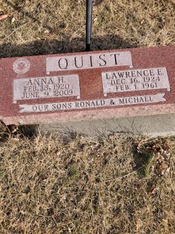
Anna Hensena Johnson Quist
| Birth | : | 18 Feb 1920 Royal, Clay County, Iowa, USA |
| Death | : | 9 Jun 2009 Spencer, Clay County, Iowa, USA |
| Burial | : | Riverside Cemetery, Spencer, Clay County, USA |
| Coordinate | : | 43.1441994, -95.1671982 |
| Plot | : | Block:7 Lot:35 Space:2 |
| Description | : | Anna Hensena Quist, the daughter of Carl H. and Agnes (Byggere) Johnson, was born on February 18, 1920 in Royal, Iowa. She was raised and received her early education in Spencer, graduating from Spencer High School. Following graduation, Anna served six months in the military with the WAC's during WWII. On March 20, 1953, Anna married Lawrence Quist in Spencer, Iowa. Following their marriage, they lived in Spencer, where Anna worked as a custodian for N.W. Bell Telephone Company from 1968 until she retired in 1985. Anna was an active member of Bethany Lutheran Church. She was also a member... Read More |
frequently asked questions (FAQ):
-
Where is Anna Hensena Johnson Quist's memorial?
Anna Hensena Johnson Quist's memorial is located at: Riverside Cemetery, Spencer, Clay County, USA.
-
When did Anna Hensena Johnson Quist death?
Anna Hensena Johnson Quist death on 9 Jun 2009 in Spencer, Clay County, Iowa, USA
-
Where are the coordinates of the Anna Hensena Johnson Quist's memorial?
Latitude: 43.1441994
Longitude: -95.1671982
Family Members:
Parent

Spouse
Siblings
Flowers:


Nearby Cemetories:
1. Riverside Cemetery
Spencer, Clay County, USA
Coordinate: 43.1441994, -95.1671982
2. Dewey Readmore Books Memorial
Spencer, Clay County, USA
Coordinate: 43.1403999, -95.1443024
3. North Lawn Cemetery
Spencer, Clay County, USA
Coordinate: 43.1600000, -95.1470000
4. Evergreen Cemetery
Clay County, USA
Coordinate: 43.2052994, -95.2086029
5. Fairview Cemetery
Clay County, USA
Coordinate: 43.1899986, -95.0800018
6. Swedish Lutheran Cemetery
Royal, Clay County, USA
Coordinate: 43.0683000, -95.2350000
7. Dickens Cemetery
Dickens, Clay County, USA
Coordinate: 43.1280000, -95.0155000
8. Rosehill Cemetery
Clay County, USA
Coordinate: 43.0368996, -95.0919037
9. Lone Tree Cemetery
Everly, Clay County, USA
Coordinate: 43.1411018, -95.3347015
10. Little Sioux Lutheran Cemetery
Milford, Dickinson County, USA
Coordinate: 43.2702065, -95.2109528
11. First Reformed Cemetery
Clay County, USA
Coordinate: 43.2399500, -95.2889000
12. Lincoln Cemetery
Rossie, Clay County, USA
Coordinate: 43.0111008, -95.2313995
13. Willow Creek Cemetery
Royal, Clay County, USA
Coordinate: 43.0214005, -95.2885971
14. Liberty Cemetery
Greenville, Clay County, USA
Coordinate: 42.9897003, -95.1417007
15. Clay Center Cemetery
Royal, Clay County, USA
Coordinate: 43.0410995, -95.3272018
16. Milford Cemetery
Milford, Dickinson County, USA
Coordinate: 43.3092003, -95.1481018
17. TriMello Cemetery
Royal, Clay County, USA
Coordinate: 43.0682983, -95.3728027
18. Logan Township Cemetery
Clay County, USA
Coordinate: 43.0489006, -94.9747009
19. Zion Methodist Cemetery
Clay County, USA
Coordinate: 42.9808006, -95.2497025
20. Calvary Cemetery
Milford, Dickinson County, USA
Coordinate: 43.3213997, -95.1688995
21. Fanny Fern Cemetery
Clay County, USA
Coordinate: 42.9530983, -95.1607971
22. Crown Hill Cemetery
Ruthven, Palo Alto County, USA
Coordinate: 43.1328011, -94.8878021
23. Calvary Cemetery
Ruthven, Palo Alto County, USA
Coordinate: 43.1314011, -94.8869019
24. Westport Cemetery
Dickinson County, USA
Coordinate: 43.3130989, -95.3289032