Anna Louie Bertha Draves Drews
| Birth | : | 24 Feb 1890 Grant, Perkins County, Nebraska, USA |
| Death | : | 17 Nov 1903 Dows, Wright County, Iowa, USA |
| Burial | : | Saint Pauls Evangelical Lutheran Cemetery, Latimer, Franklin County, USA |
| Coordinate | : | 42.7652817, -93.3719406 |
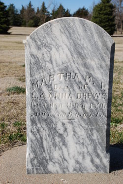
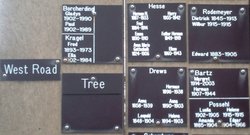
| Description | : | ANNA LOUIE BERTHA DRAVES, b. February 24, 1890, Grant, Perkins County, Nebraska; d. November 17, 1903, Dows, Wright County, Iowa. More About ANNA LOUIE BERTHA DRAVES:Burial: November 1903, St. Paul's Lutheran Cemetery, Latimer, Franklin County, Iowa. Christened: April 07, 1890, Grant, Perkins County, Nebraska SOURCE Ralph Draves http://www.rh-mb-draves.com/draves_family.htm ------- Many thanks for MARKER photos AND CEMETERY information below provided by findagrave contributor Tonip (#47663567) Also for the following Drews family information which is exactly as typed in the cemetery book at the library in Hampton, Iowa Latimer Star Jan 14, 1904 page 1 Col. 5 Leopold Drews, near Dows, a member of the German Lutheran Church died... Read More |
frequently asked questions (FAQ):
-
Where is Anna Louie Bertha Draves Drews's memorial?
Anna Louie Bertha Draves Drews's memorial is located at: Saint Pauls Evangelical Lutheran Cemetery, Latimer, Franklin County, USA.
-
When did Anna Louie Bertha Draves Drews death?
Anna Louie Bertha Draves Drews death on 17 Nov 1903 in Dows, Wright County, Iowa, USA
-
Where are the coordinates of the Anna Louie Bertha Draves Drews's memorial?
Latitude: 42.7652817
Longitude: -93.3719406
Family Members:
Parent
Siblings
Flowers:
Nearby Cemetories:
1. Saint Pauls Evangelical Lutheran Cemetery
Latimer, Franklin County, USA
Coordinate: 42.7652817, -93.3719406
2. Coulter Cemetery
Coulter, Franklin County, USA
Coordinate: 42.7388916, -93.3716736
3. Marion Center Cemetery
Latimer, Franklin County, USA
Coordinate: 42.7738991, -93.3178024
4. Saint Peter's Lutheran Church Cemetery
Coulter, Franklin County, USA
Coordinate: 42.7167015, -93.3803024
5. Saint Johns Lutheran Cemetery
Hampton, Franklin County, USA
Coordinate: 42.7197189, -93.3397217
6. Alexander Cemetery
Alexander, Franklin County, USA
Coordinate: 42.8041687, -93.4591675
7. Zion Reformed Church Cemetery
Franklin County, USA
Coordinate: 42.8413887, -93.3188934
8. Trinity Lutheran Cemetery
Hampton, Franklin County, USA
Coordinate: 42.7667007, -93.2518997
9. Morgan Cemetery
Morgan Township, Franklin County, USA
Coordinate: 42.6741982, -93.4100037
10. Old Chapin Cemetery
Chapin, Franklin County, USA
Coordinate: 42.8232994, -93.2624969
11. Mount Hope Cemetery
Morgan Township, Franklin County, USA
Coordinate: 42.6777992, -93.4792023
12. Holland Cemetery
Wisner Township, Franklin County, USA
Coordinate: 42.8638916, -93.4791718
13. Way Side Cemetery
Chapin, Franklin County, USA
Coordinate: 42.8293991, -93.2225037
14. Hampton Cemetery
Hampton, Franklin County, USA
Coordinate: 42.7452812, -93.1975021
15. Olson Cemetery
Popejoy, Franklin County, USA
Coordinate: 42.6383018, -93.4403000
16. Maynes Grove Cemetery
Hampton, Franklin County, USA
Coordinate: 42.6577988, -93.2514038
17. Richland Lutheran Cemetery
Thornton, Cerro Gordo County, USA
Coordinate: 42.9086113, -93.3683319
18. Graceland Cemetery
Rowan, Wright County, USA
Coordinate: 42.7453003, -93.5714035
19. Fairview Cemetery
Dows, Wright County, USA
Coordinate: 42.6511002, -93.5044022
20. Shobes Grove Cemetery
Franklin County, USA
Coordinate: 42.9000015, -93.2722168
21. Immanuel Reformed Cemetery
Belmond, Wright County, USA
Coordinate: 42.8635000, -93.5484000
22. Meservey Cemetery
Meservey, Franklin County, USA
Coordinate: 42.9080582, -93.4786072
23. Towle Cemetery
Geneva, Franklin County, USA
Coordinate: 42.6836014, -93.1785965
24. Richard Cemetery
Meservey, Cerro Gordo County, USA
Coordinate: 42.9089012, -93.4925003


