
| Birth | : | 4 Jun 1888 Mine La Motte, Madison County, Missouri, USA |
| Death | : | 27 Jan 1948 Flat River, St. Francois County, Missouri, USA |
| Burial | : | Greenwood Cemetery, Mobridge, Walworth County, USA |
| Coordinate | : | 45.5527992, -100.4263992 |
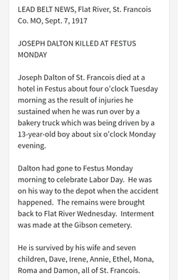
| Description | : | Anna Mabel Dalton was the daughter of Joseph S. and Julietta LaPlant Dalton. She married Lazarus Presslie Pritchett January 20, 1907 in Flat River, St. Francois Co., MO. and he passed away March 7, 1912 and he is buried in Desloge, cemetery unknown. Three children were born to this union: Ivan Jackson; Presslie Leonard; and Oral Sylvester Pritchett. She married Norice Frank Arenz ca 1915. One known child was born of this union, Ilene J. Arenz. Norice died between 1930 and 1948, cemetery unknown. Anna died in Big River Township, en route to St. Louis from St. Francois Co., per MO DC 2193. She... Read More |
frequently asked questions (FAQ):
-
Where is Anna Mabel Dalton Arenz's memorial?
Anna Mabel Dalton Arenz's memorial is located at: Greenwood Cemetery, Mobridge, Walworth County, USA.
-
When did Anna Mabel Dalton Arenz death?
Anna Mabel Dalton Arenz death on 27 Jan 1948 in Flat River, St. Francois County, Missouri, USA
-
Where are the coordinates of the Anna Mabel Dalton Arenz's memorial?
Latitude: 45.5527992
Longitude: -100.4263992
Family Members:
Parent
Siblings

Children


Nearby Cemetories:
1. Greenwood Cemetery
Mobridge, Walworth County, USA
Coordinate: 45.5527992, -100.4263992
2. Fool Soldiers Band Monument
Mobridge, Walworth County, USA
Coordinate: 45.5384890, -100.4338790
3. Mobridge City Cemetery
Mobridge, Walworth County, USA
Coordinate: 45.5372000, -100.4180000
4. Grace Cemetery
Mobridge, Walworth County, USA
Coordinate: 45.5367012, -100.3858032
5. Jedediah Strong Smith Historical Monument
Mobridge, Walworth County, USA
Coordinate: 45.5741600, -100.4832600
6. Sitting Bull Monument
Corson County, USA
Coordinate: 45.5169400, -100.4851800
7. Sacagawea Monument
Corson County, USA
Coordinate: 45.5159000, -100.4881000
8. Saint Elizabeth Cemetery
Wakpala, Corson County, USA
Coordinate: 45.6423880, -100.5149280
9. Glenham Cemetery
Glenham, Walworth County, USA
Coordinate: 45.5369000, -100.2632000
10. Evarts Cemetery
Walworth County, USA
Coordinate: 45.4632988, -100.3174973
11. Saint Bedes Cemetery
Wakpala, Corson County, USA
Coordinate: 45.6581001, -100.5252991
12. Ratrus German Congregational of Glenham Cemetery
Glenham, Walworth County, USA
Coordinate: 45.6371340, -100.2143640
13. Saint Peter Congregational Cemetery
Mound City, Campbell County, USA
Coordinate: 45.6371100, -100.2143000
14. Norway Lutheran Church Cemetery
Mound City, Campbell County, USA
Coordinate: 45.6445000, -100.1926000
15. Mad Bear Mission Cemetery
Corson County, USA
Coordinate: 45.7355995, -100.3431015
16. Ascension Cemetery
Dewey County, USA
Coordinate: 45.3598200, -100.3948900
17. Sacred Heart Cemetery
Corson County, USA
Coordinate: 45.6571999, -100.6875000
18. Trail City Cemetery
Trail City, Corson County, USA
Coordinate: 45.4733009, -100.7082977
19. Long Hill Cemetery
Wakpala, Corson County, USA
Coordinate: 45.6575012, -100.6980972
20. Bethany Cemetery
Selby, Walworth County, USA
Coordinate: 45.5938988, -100.1102982
21. Saint Johns Cemetery
Promise, Dewey County, USA
Coordinate: 45.3541985, -100.5875015
22. Kvernes Cemetery
Pollock, Campbell County, USA
Coordinate: 45.7616997, -100.2544022
23. Bethlehem Cemetery
Selby, Walworth County, USA
Coordinate: 45.5363998, -100.0783005
24. Virgin Creek UCC Cemetery
La Plant, Dewey County, USA
Coordinate: 45.3419400, -100.6163900