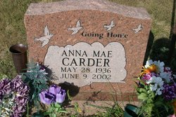
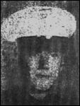
Anna Mae Propst Carder
| Birth | : | 28 May 1936 Franklin, Pendleton County, West Virginia, USA |
| Death | : | 9 Jun 2002 Cumberland, Allegany County, Maryland, USA |
| Burial | : | Rosalia IOOF Evergreen Cemetery, Rosalia, Whitman County, USA |
| Coordinate | : | 47.2599983, -117.3656006 |
frequently asked questions (FAQ):
-
Where is Anna Mae Propst Carder's memorial?
Anna Mae Propst Carder's memorial is located at: Rosalia IOOF Evergreen Cemetery, Rosalia, Whitman County, USA.
-
When did Anna Mae Propst Carder death?
Anna Mae Propst Carder death on 9 Jun 2002 in Cumberland, Allegany County, Maryland, USA
-
Where are the coordinates of the Anna Mae Propst Carder's memorial?
Latitude: 47.2599983
Longitude: -117.3656006
Family Members:
Parent
Spouse
Siblings
Flowers:
Nearby Cemetories:
1. Rosalia IOOF Evergreen Cemetery
Rosalia, Whitman County, USA
Coordinate: 47.2599983, -117.3656006
2. Riggs Cemetery
Rosalia, Whitman County, USA
Coordinate: 47.2479900, -117.3429100
3. Holy Rosary Cemetery
Rosalia, Whitman County, USA
Coordinate: 47.2094600, -117.3499100
4. Pine City Cemetery
Pine City, Whitman County, USA
Coordinate: 47.1953011, -117.5147018
5. Waverly Cemetery
Waverly, Spokane County, USA
Coordinate: 47.3432999, -117.2366028
6. Latah Evergreen Cemetery
Latah, Spokane County, USA
Coordinate: 47.2961006, -117.1619034
7. Thornton Cemetery
Thornton, Whitman County, USA
Coordinate: 47.1146355, -117.3807907
8. Oakesdale Cemetery
Oakesdale, Whitman County, USA
Coordinate: 47.1371994, -117.2407990
9. Lone Pine Cemetery
Tekoa, Whitman County, USA
Coordinate: 47.2256012, -117.1489029
10. Sheahan Cemetery
Thornton, Whitman County, USA
Coordinate: 47.1091000, -117.3868000
11. Broadacres Cemetery
Spangle, Spokane County, USA
Coordinate: 47.4144440, -117.3647220
12. Rosewood Cemetery
Fairfield, Spokane County, USA
Coordinate: 47.3474998, -117.1722031
13. Spangle Cemetery
Spangle, Spokane County, USA
Coordinate: 47.4202766, -117.3775024
14. Latah Cemetery
Latah, Spokane County, USA
Coordinate: 47.2821999, -117.1264038
15. Fairfield Cemetery
Fairfield, Spokane County, USA
Coordinate: 47.3699989, -117.1402969
16. Goldenrod Cemetery
Tekoa, Whitman County, USA
Coordinate: 47.2117004, -117.0727997
17. Mount Hope Cemetery
Mount Hope, Spokane County, USA
Coordinate: 47.4477997, -117.2382965
18. Sacred Heart Catholic Cemetery
Tekoa, Whitman County, USA
Coordinate: 47.2398300, -117.0587100
19. Saint John Cemetery
Saint John, Whitman County, USA
Coordinate: 47.0780983, -117.5350037
20. Fairview Cemetery
Rockford, Spokane County, USA
Coordinate: 47.4421997, -117.1296997
21. Butte Cemetery
Spokane County, USA
Coordinate: 47.3850000, -117.0577780
22. Bethel Cemetery
Steptoe, Whitman County, USA
Coordinate: 47.0052986, -117.3460999
23. Wood Memorial Cemetery
Valleyford, Spokane County, USA
Coordinate: 47.5071983, -117.2692032
24. Spring Valley Cemetery
Spring Valley, Spokane County, USA
Coordinate: 47.5150140, -117.2713870

