| Birth | : | 20 Oct 1821 |
| Death | : | 21 Mar 1876 |
| Burial | : | Tokurenin-temple, Nabari-shi, Japan |
| Coordinate | : | 34.6190270, 136.0967230 |
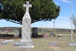
| Description | : | This stone reads (as close as I can decipher, corrections are welcome!): Anna Maria Erste gattin von Nic. Emanuel And spaether von H. Moellenbeck Geborenden 20 Oct 1821 Gestorben den 21 Marz 1876 It seems to indicate that she was first married to Nic. Emanuel, and later to H. Moellenbeck, but it seems to be written in a dialect I do not understand (or perhaps I have misread the text.) On the side of this stone is engraved: Erected for our Mother by her sons John Emanuel Peter J. Math. A. D. 1878 |
frequently asked questions (FAQ):
-
Where is Anna Maria Wilhelm Emanuel Moellenbeck's memorial?
Anna Maria Wilhelm Emanuel Moellenbeck's memorial is located at: Tokurenin-temple, Nabari-shi, Japan.
-
When did Anna Maria Wilhelm Emanuel Moellenbeck death?
Anna Maria Wilhelm Emanuel Moellenbeck death on 21 Mar 1876 in
-
Where are the coordinates of the Anna Maria Wilhelm Emanuel Moellenbeck's memorial?
Latitude: 34.6190270
Longitude: 136.0967230
Family Members:
Children
Flowers:
Nearby Cemetories:
1. Tokurenin-temple
Nabari-shi, Japan
Coordinate: 34.6190270, 136.0967230
2. Saihoji-temple
Nabari-shi, Japan
Coordinate: 34.6211312, 136.0844243
3. Nishi-Hokkeji Mound
Iga-shi, Japan
Coordinate: 34.6647961, 136.1748180
4. Tomb of Akahito Yamabe-no
Uda-shi, Japan
Coordinate: 34.5570610, 135.9769250
5. Kuhonji-temple
Iga-shi, Japan
Coordinate: 34.7466320, 136.1229600
6. Sairenji-temple
Iga-shi, Japan
Coordinate: 34.7596000, 136.1061500
7. Sankei-zen-ji-temple
Iga-shi, Japan
Coordinate: 34.7621860, 136.1309450
8. Shosoji-temple
Iga-shi, Japan
Coordinate: 34.7644653, 136.1301360
9. Daichoji-temple
Iga-shi, Japan
Coordinate: 34.7641320, 136.1341870
10. Manpukuji-temple
Iga-shi, Japan
Coordinate: 34.7651000, 136.1347000
11. Jyogyouji-temple
Iga-shi, Japan
Coordinate: 34.7660386, 136.1345208
12. Kaikaji-temple
Iga-shi, Japan
Coordinate: 34.7708020, 136.1218620
13. Tawara-no Higashi-no Misasagi
Nara-shi, Japan
Coordinate: 34.6676880, 135.9133980
14. Grave of Yasumaro Ohno
Nara-shi, Japan
Coordinate: 34.6654230, 135.9071850
15. Hotokuji-temple
Nara-shi, Japan
Coordinate: 34.7316520, 135.9539550
16. Tawara-no Nishi-no Misasagi
Nara-shi, Japan
Coordinate: 34.6578700, 135.8921900
17. Tokugenji-temple
Uda-shi, Japan
Coordinate: 34.4870890, 135.9260530
18. Ryogenji-temple
Iga-shi, Japan
Coordinate: 34.8030177, 136.1672133
19. Fusumada-ryo
Tenri-shi, Japan
Coordinate: 34.5684260, 135.8510670
20. Yashima-no-Misasagi
Nara-shi, Japan
Coordinate: 34.6475390, 135.8417380
21. Yamanobe-no-Michino-Magarinookanoe-no-Misasagi
Tenri-shi, Japan
Coordinate: 34.5576340, 135.8491020
22. Osakanouchi-no-Misasagi
Sakurai-shi, Japan
Coordinate: 34.5075700, 135.8756800
23. Yunotani Cemetery
Yoshino-gun, Japan
Coordinate: 34.4255810, 135.9843520
24. Yamanobe-no-Michinoe-no-Misasagi
Tenri-shi, Japan
Coordinate: 34.5508360, 135.8487400


