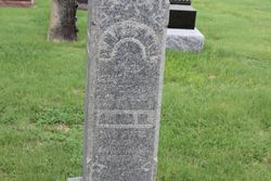
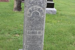
Anna Mariah Getrost Nedrow
| Birth | : | 12 Apr 1827 Darmstadt, Stadtkreis Darmstadt, Hessen, Germany |
| Death | : | 17 Aug 1909 Stockton, Rooks County, Kansas, USA |
| Burial | : | Saint Marys Cemetery, Woodburn, Clarke County, USA |
| Coordinate | : | 41.0190000, -93.6045000 |
| Plot | : | Block 4, Lot 2, Space 5 |
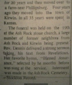
| Description | : | Posted by Brenda Reeder in Obituaries (1884-1949) on Rooks Co., KSGenWeb: Stockton Review, 19 Aug 1909: Mrs. (Anna) Mariah Nedrow Death of Nedrow Among the pioneers of Rooks county was Mrs. (Anna) Mariah Nedrow who came with her husband, George M. Nedrow to what is now Ash Rock township in 1876. Here they lived for many years, later selling out their farm there and purchasing a farm in Valley township, Phillips county, where they lived till about three years ago when they moved to Kirwin. Here Mr. Nedrow died about three years ago, after which Mrs. Nedrow came here and has since made... Read More |
frequently asked questions (FAQ):
-
Where is Anna Mariah Getrost Nedrow's memorial?
Anna Mariah Getrost Nedrow's memorial is located at: Saint Marys Cemetery, Woodburn, Clarke County, USA.
-
When did Anna Mariah Getrost Nedrow death?
Anna Mariah Getrost Nedrow death on 17 Aug 1909 in Stockton, Rooks County, Kansas, USA
-
Where are the coordinates of the Anna Mariah Getrost Nedrow's memorial?
Latitude: 41.0190000
Longitude: -93.6045000
Family Members:
Parent
Spouse
Siblings
Flowers:
Nearby Cemetories:
1. Saint Marys Cemetery
Woodburn, Clarke County, USA
Coordinate: 41.0190000, -93.6045000
2. Woodburn Cemetery
Woodburn, Clarke County, USA
Coordinate: 41.0080000, -93.6000000
3. Ottawa Cemetery
Ottawa, Clarke County, USA
Coordinate: 41.0231018, -93.5899963
4. Lewis Cemetery
Woodburn, Clarke County, USA
Coordinate: 40.9975014, -93.6485977
5. Horton Cemetery
Smyrna, Clarke County, USA
Coordinate: 40.9734192, -93.6321793
6. Last Chance Cemetery
Last Chance, Lucas County, USA
Coordinate: 40.9579000, -93.5535000
7. Lost Chord Cemetery
Smyrna, Clarke County, USA
Coordinate: 40.9412689, -93.6088333
8. Smyrna Cemetery
Smyrna, Clarke County, USA
Coordinate: 40.9364014, -93.6156006
9. Old Smyrna Cemetery
Smyrna, Clarke County, USA
Coordinate: 40.9361000, -93.6159500
10. Rose Hill Cemetery
Lucas, Lucas County, USA
Coordinate: 41.0435000, -93.4985000
11. Wren Hill Pioneer Cemetery
Otter Creek Township, Lucas County, USA
Coordinate: 41.0887760, -93.5262200
12. Harrison Cemetery
Liberty, Clarke County, USA
Coordinate: 41.1156000, -93.5896000
13. Twyford Cemetery
Liberty, Clarke County, USA
Coordinate: 41.1083295, -93.6670303
14. Walker Cemetery
Lucas County, USA
Coordinate: 41.1150017, -93.5567017
15. Jones Plot
Osceola, Clarke County, USA
Coordinate: 40.9692726, -93.7288284
16. Union Chapel Cemetery
Osceola, Clarke County, USA
Coordinate: 41.0811005, -93.7213974
17. Blair Cemetery
Smyrna, Clarke County, USA
Coordinate: 40.9098816, -93.6254883
18. Hebron Cemetery
Clarke County, USA
Coordinate: 40.9291992, -93.6911011
19. Goshen Baptist Cemetery
Lucas, Lucas County, USA
Coordinate: 40.9690000, -93.4710000
20. Brinegar Cemetery
Lucas, Lucas County, USA
Coordinate: 41.1015000, -93.4960000
21. Bethel Chapel Cemetery
Liberty, Clarke County, USA
Coordinate: 41.1395000, -93.5785000
22. Fry Hill Cemetery
Lucas, Lucas County, USA
Coordinate: 41.0425000, -93.4450000
23. Fisher-Webb Cemetery
Lucas County, USA
Coordinate: 40.9480000, -93.4713000
24. Vawn Cemetery
Osceola, Clarke County, USA
Coordinate: 41.0760498, -93.7514648


