
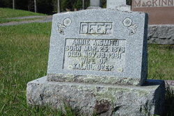
Annie Adeline Smith Deep
| Birth | : | 25 Mar 1876 |
| Death | : | 18 Nov 1961 |
| Burial | : | Old Ipswich Cemetery, Ipswich, Ipswich Borough, England |
| Coordinate | : | 52.0645820, 1.1678390 |
| Plot | : | 450 |
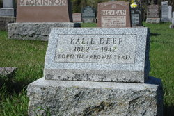
| Description | : | Plot 450 : - Annie A. Smith, Born Mar.25,1876 - Died Nov.18,1961, wife of Kalail Deep. -------------------------------------- Death Notice - The Perth Courier Newspaper - Issue of Thursday, Nov.23,1961, page 8 - Deep - At the G.W.M. Hospital, Perth, on Saturday, November 18th, 1961, Annie Adeline Smith, wife of the late Kalail Deep, in her 86th year. Elphin News - In the same issue - The community extends their deepest sympathy to the relatives of Mrs. Annie Deep of Maberly, formerly of Elphin, who passed away in the G.W.M. Hospital in Perth, on Saturday. |
frequently asked questions (FAQ):
-
Where is Annie Adeline Smith Deep's memorial?
Annie Adeline Smith Deep's memorial is located at: Old Ipswich Cemetery, Ipswich, Ipswich Borough, England.
-
When did Annie Adeline Smith Deep death?
Annie Adeline Smith Deep death on 18 Nov 1961 in
-
Where are the coordinates of the Annie Adeline Smith Deep's memorial?
Latitude: 52.0645820
Longitude: 1.1678390
Family Members:
Parent

Spouse
Siblings

Flowers:


Nearby Cemetories:
1. Old Ipswich Cemetery
Ipswich, Ipswich Borough, England
Coordinate: 52.0645820, 1.1678390
2. New Ipswich Cemetery
Ipswich, Ipswich Borough, England
Coordinate: 52.0677840, 1.1720420
3. Ipswich Crematorium
Ipswich, Ipswich Borough, England
Coordinate: 52.0688070, 1.1739190
4. Lawn Cemetery
Ipswich, Ipswich Borough, England
Coordinate: 52.0702740, 1.1747850
5. St Margaret's Churchyard
Ipswich, Ipswich Borough, England
Coordinate: 52.0594310, 1.1585370
6. St Michael's Churchyard
Ipswich, Ipswich Borough, England
Coordinate: 52.0567430, 1.1601350
7. Ipswich Prison Cemetery
Ipswich, Ipswich Borough, England
Coordinate: 52.0561000, 1.1615000
8. St Mary Le Tower Church
Ipswich, Ipswich Borough, England
Coordinate: 52.0583620, 1.1554510
9. Christ Church
Ipswich, Ipswich Borough, England
Coordinate: 52.0561100, 1.1580460
10. Saint Lawrence Churchyard
Ipswich, Ipswich Borough, England
Coordinate: 52.0573890, 1.1548010
11. St Stephen Churchyard
Ipswich, Ipswich Borough, England
Coordinate: 52.0565440, 1.1550610
12. St Clement Churchyard
Ipswich, Ipswich Borough, England
Coordinate: 52.0539000, 1.1617700
13. Ipswich Whitefriars Priory (Defunct)
Ipswich, Ipswich Borough, England
Coordinate: 52.0567880, 1.1539420
14. Holy Trinity Churchyard
Ipswich, Ipswich Borough, England
Coordinate: 52.0525390, 1.1660850
15. Saint Mary At Elms
Ipswich, Ipswich Borough, England
Coordinate: 52.0571220, 1.1501980
16. Unitarian Meeting House Cemetery
Ipswich, Ipswich Borough, England
Coordinate: 52.0560000, 1.1512400
17. St. Mary's Church at Quay
Ipswich, Ipswich Borough, England
Coordinate: 52.0528900, 1.1565330
18. Millennium Cemetery
Ipswich, Ipswich Borough, England
Coordinate: 52.0764320, 1.1793140
19. Friends Meeting House Burial Ground
Ipswich, Ipswich Borough, England
Coordinate: 52.0529880, 1.1556814
20. Saint Nicholas' Churchyard
Ipswich, Ipswich Borough, England
Coordinate: 52.0547670, 1.1515930
21. St. Peter's Churchyard
Ipswich, Ipswich Borough, England
Coordinate: 52.0531930, 1.1541260
22. St Matthew Churchyard
Ipswich, Ipswich Borough, England
Coordinate: 52.0589060, 1.1465690
23. Grey Friars
Ipswich, Ipswich Borough, England
Coordinate: 52.0547510, 1.1505460
24. St. Mary at Stoke Churchyard
Ipswich, Ipswich Borough, England
Coordinate: 52.0505880, 1.1522930