
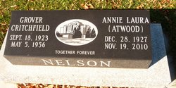

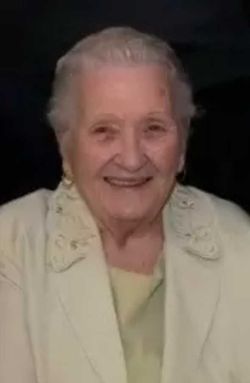
Annie Laura “Laura” Atwood Nelson
| Birth | : | 28 Dec 1927 Caithness, East Kootenay Regional District, British Columbia, Canada |
| Death | : | 10 Nov 2010 Raymond, Lethbridge Census Division, Alberta, Canada |
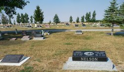
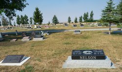
| Burial | : | Magrath Cemetery, Magrath, Claresholm Census Division, Canada |
| Coordinate | : | 49.3985700, -112.8648700 |
| Plot | : | Block 7 |
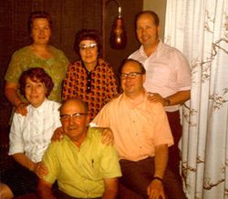
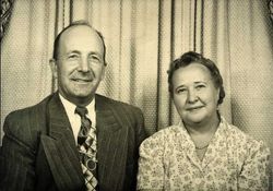
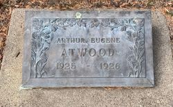
| Description | : | NELSON LAURA (ATWOOD) NELSON, beloved wife of the late Grover Nelson, passed away in Raymond on Friday, November 19, 2010, at the age of 82 years. She is survived by her two children: Darrel (Marsha) Nelson and Janice (Richard) Anderson. She is also survived by 10 grandchildren and 20 great grandchildren. Laura will be sadly missed by her brother Duwayne (Mauricette) Atwood and sisters Lavina (Brownie) Witbeck and Gwen George. She was predeceased by her husband, Grover, and her parents, Arthur and Laura Atwood, and her brothers, Arthur (who died in infancy), and Gail; as well as her in-laws, Darrel and Mary Nelson,... Read More |
frequently asked questions (FAQ):
-
Where is Annie Laura “Laura” Atwood Nelson's memorial?
Annie Laura “Laura” Atwood Nelson's memorial is located at: Magrath Cemetery, Magrath, Claresholm Census Division, Canada.
-
When did Annie Laura “Laura” Atwood Nelson death?
Annie Laura “Laura” Atwood Nelson death on 10 Nov 2010 in Raymond, Lethbridge Census Division, Alberta, Canada
-
Where are the coordinates of the Annie Laura “Laura” Atwood Nelson's memorial?
Latitude: 49.3985700
Longitude: -112.8648700
Family Members:
Parent

Spouse
Siblings
Flowers:


Nearby Cemetories:
1. Magrath Cemetery
Magrath, Claresholm Census Division, Canada
Coordinate: 49.3985700, -112.8648700
2. Hutterville Hutterite Cemetery
Magrath, Claresholm Census Division, Canada
Coordinate: 49.3503165, -112.7701038
3. Rockport Colony Cemetery
Magrath, Claresholm Census Division, Canada
Coordinate: 49.3027780, -112.8136110
4. Spring Valley Hutterite Colony Cemetery
Spring Coulee, Claresholm Census Division, Canada
Coordinate: 49.3517043, -113.0551519
5. Spring Coulee Cemetery
Spring Coulee, Claresholm Census Division, Canada
Coordinate: 49.3412100, -113.0541400
6. Temple Hill Cemetery
Raymond, Lethbridge Census Division, Canada
Coordinate: 49.4916300, -112.6605200
7. East Raymond Hutterite Colony Cemetery
Raymond, Lethbridge Census Division, Canada
Coordinate: 49.4185305, -112.5791329
8. Stirling Mennonite Church Cemetery
Stirling, Lethbridge Census Division, Canada
Coordinate: 49.4607570, -112.5387970
9. Wolf Creek Hutterite Colony Cemetery
Stirling, Lethbridge Census Division, Canada
Coordinate: 49.4119142, -112.5163705
10. Crystal Spring Hutterite Colony Cemetery
Magrath, Claresholm Census Division, Canada
Coordinate: 49.1702490, -112.8048290
11. Stirling Cemetery
Stirling, Lethbridge Census Division, Canada
Coordinate: 49.5093400, -112.5380000
12. West Raley Hutterite Cemetery
Raley, Claresholm Census Division, Canada
Coordinate: 49.2908857, -113.2283616
13. Mountain View Cemetery
Lethbridge, Lethbridge Census Division, Canada
Coordinate: 49.6800385, -112.8297729
14. Woolford Cemetery
Woolford, Claresholm Census Division, Canada
Coordinate: 49.1945800, -113.1652300
15. Wilson Siding Hutterite Cemetery
Wilson, Lethbridge Census Division, Canada
Coordinate: 49.6203914, -112.5781130
16. Indian Battle Park
Lethbridge, Lethbridge Census Division, Canada
Coordinate: 49.6928200, -112.8582900
17. Saint Catherine Cemetery
Stand Off, Claresholm Census Division, Canada
Coordinate: 49.4516900, -113.3112300
18. Big Bend Hutterite Colony
Cardston, Claresholm Census Division, Canada
Coordinate: 49.1636110, -113.1411110
19. Standoff Hutterite Colony Cemetery
Stand Off, Claresholm Census Division, Canada
Coordinate: 49.4829507, -113.3130885
20. Archmount Cemetery
Lethbridge, Lethbridge Census Division, Canada
Coordinate: 49.7057900, -112.9017500
21. Saint Patrick's Cemetery
Lethbridge, Lethbridge Census Division, Canada
Coordinate: 49.7084618, -112.8428726
22. East Cardston Hutterite Cemetery
Cardston, Claresholm Census Division, Canada
Coordinate: 49.1908348, -113.2258004
23. New Dayton Community Cemetery
New Dayton, Lethbridge Census Division, Canada
Coordinate: 49.4254300, -112.3601800
24. Royal View Memorial Cemetery
Lethbridge, Lethbridge Census Division, Canada
Coordinate: 49.7518540, -112.8242250