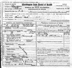
Annie Theresa “Ke-Shat” Bob
| Birth | : | 1860 Washington, USA |
| Death | : | 10 Sep 1931 Pateros, Okanogan County, Washington, USA |
| Burial | : | Fort Okanogan Memorial Cemetery, Okanogan, Okanogan County, USA |
| Coordinate | : | 48.1594009, -119.6632996 |
| Description | : | Unsure if this is the correct cemetery. Death certificate only stated buried near Pateros but would make sense if she was buried here since this is where other relatives are buried. Washington Deaths and Burials, 1810-1960 Name: Annie Bob Event Type: Burial Event Date: 12 Sep 1931 Event Place: Pateros, Okanogan, Washington, United States Event Place (Original): Near Pateros, Okanogan, Wash Gender: Female Age: 89 Marital Status: Widowed Ethnicity: American Race: Indian Birth Date: 1842 Birthplace: Washington Death Date: 10 Sep 1931 Death Place: Near Pateros, Okanogan, Wash. |
frequently asked questions (FAQ):
-
Where is Annie Theresa “Ke-Shat” Bob's memorial?
Annie Theresa “Ke-Shat” Bob's memorial is located at: Fort Okanogan Memorial Cemetery, Okanogan, Okanogan County, USA.
-
When did Annie Theresa “Ke-Shat” Bob death?
Annie Theresa “Ke-Shat” Bob death on 10 Sep 1931 in Pateros, Okanogan County, Washington, USA
-
Where are the coordinates of the Annie Theresa “Ke-Shat” Bob's memorial?
Latitude: 48.1594009
Longitude: -119.6632996
Family Members:
Spouse
Flowers:
Nearby Cemetories:
1. Fort Okanogan Memorial Cemetery
Okanogan, Okanogan County, USA
Coordinate: 48.1594009, -119.6632996
2. Elizabeth Osborn Mikel Gravesite
Brewster, Okanogan County, USA
Coordinate: 48.1498900, -119.7514700
3. Locust Grove Cemetery
Brewster, Okanogan County, USA
Coordinate: 48.1114006, -119.7746964
4. Chiliwist Cemetery
Okanogan County, USA
Coordinate: 48.2630997, -119.7363968
5. Paradise Hill Cemetery
Brewster, Okanogan County, USA
Coordinate: 48.1848980, -119.8411900
6. Cameron Lake Pioneer Memorial Cemetery
Malott, Okanogan County, USA
Coordinate: 48.2708330, -119.5700000
7. Malott Community Cemetery
Malott, Okanogan County, USA
Coordinate: 48.2925000, -119.7047300
8. Bridgeport Cemetery
Bridgeport, Douglas County, USA
Coordinate: 48.0050000, -119.6738800
9. Packwood Memorial Cemetery
Dyer, Douglas County, USA
Coordinate: 48.0118305, -119.8178880
10. Pateros Cemetery
Pateros, Okanogan County, USA
Coordinate: 48.0516600, -119.9097300
11. Okanogan City Cemetery
Okanogan, Okanogan County, USA
Coordinate: 48.3546982, -119.6061020
12. Dick Family Cemetery
Okanogan County, USA
Coordinate: 48.0502700, -119.9241700
13. Miller Family Cemetery
Okanogan County, USA
Coordinate: 48.0530300, -119.9288000
14. Spring Coulee Family Cemetery
Okanogan County, USA
Coordinate: 48.3895950, -119.6289460
15. Methow Cemetery
Methow, Okanogan County, USA
Coordinate: 48.1102982, -120.0124969
16. Omak Memorial Cemetery
Okanogan, Okanogan County, USA
Coordinate: 48.3874000, -119.5565800
17. Okanogan Valley Memorial Gardens
Omak, Okanogan County, USA
Coordinate: 48.3911018, -119.5691986
18. Saint Marys Mission Catholic Cemetery
Omak, Okanogan County, USA
Coordinate: 48.3752800, -119.4452800
19. Kartar Cemetery
Okanogan County, USA
Coordinate: 48.2197100, -119.2694500
20. Sand Flats Cemetery
Omak, Okanogan County, USA
Coordinate: 48.4157600, -119.4836600
21. Brooks Cemetery
Omak, Okanogan County, USA
Coordinate: 48.3786110, -119.3941670
22. Booher Grave
Riverside, Okanogan County, USA
Coordinate: 48.3409070, -119.3244000
23. Buckingham Cemetery
Douglas County, USA
Coordinate: 47.8669014, -119.6286011
24. Stoddard Gravesite
Okanogan, Okanogan County, USA
Coordinate: 48.4531140, -119.5411680


