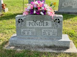
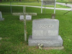
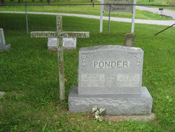
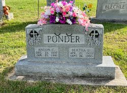
Anton Charles “Carl” Ponder
| Birth | : | 28 Dec 1897 Apple Creek, Perry County, Missouri, USA |
| Death | : | 21 Jan 1981 Perryville, Perry County, Missouri, USA |
| Burial | : | Saint Paul Lutheran Church Memorial Garden, Davenport, Scott County, USA |
| Coordinate | : | 41.5412589, -90.5747720 |
frequently asked questions (FAQ):
-
Where is Anton Charles “Carl” Ponder's memorial?
Anton Charles “Carl” Ponder's memorial is located at: Saint Paul Lutheran Church Memorial Garden, Davenport, Scott County, USA.
-
When did Anton Charles “Carl” Ponder death?
Anton Charles “Carl” Ponder death on 21 Jan 1981 in Perryville, Perry County, Missouri, USA
-
Where are the coordinates of the Anton Charles “Carl” Ponder's memorial?
Latitude: 41.5412589
Longitude: -90.5747720
Family Members:
Parent
Spouse
Siblings
Children
Flowers:
Nearby Cemetories:
1. Saint Paul Lutheran Church Memorial Garden
Davenport, Scott County, USA
Coordinate: 41.5412589, -90.5747720
2. Trinity Episcopal Cathedral Columbarium
Davenport, Scott County, USA
Coordinate: 41.5316230, -90.5748420
3. Scott County Civil War Monument Site
Davenport, Scott County, USA
Coordinate: 41.5312309, -90.5756454
4. Palmer College of Chiropractic Heritage Wall
Davenport, Scott County, USA
Coordinate: 41.5294762, -90.5748596
5. Sacred Heart Cathedral Memorial
Davenport, Scott County, USA
Coordinate: 41.5299911, -90.5692520
6. Sacred Heart Cemetery
Davenport, Scott County, USA
Coordinate: 41.5433006, -90.5916977
7. Le Claire Cemetery (Defunct)
Davenport, Scott County, USA
Coordinate: 41.5259050, -90.5685600
8. Oakdale Memorial Gardens
Davenport, Scott County, USA
Coordinate: 41.5449210, -90.5513270
9. Love of Animals Petland Cemetery
Davenport, Scott County, USA
Coordinate: 41.5481400, -90.5491800
10. Le Claire Park
Davenport, Scott County, USA
Coordinate: 41.5188446, -90.5788727
11. Saint Marys Church Cemetery
Davenport, Scott County, USA
Coordinate: 41.5250015, -90.5958023
12. Putnam Museum of History and Natural Science
Davenport, Scott County, USA
Coordinate: 41.5309105, -90.6019287
13. Mount Calvary Catholic Cemetery
Davenport, Scott County, USA
Coordinate: 41.5633659, -90.5640259
14. Pine Hill Cemetery
Davenport, Scott County, USA
Coordinate: 41.5621986, -90.5558014
15. Davenport Memorial Park
Davenport, Scott County, USA
Coordinate: 41.5647011, -90.5597000
16. Mount Nebo Hebrew Cemetery
Davenport, Scott County, USA
Coordinate: 41.5643997, -90.5558014
17. Fort Armstrong Post Cemetery
Rock Island, Rock Island County, USA
Coordinate: 41.5147057, -90.5637665
18. Davenport City Cemetery
Davenport, Scott County, USA
Coordinate: 41.5191760, -90.5997460
19. Rock Island County Justice Center Grounds
Rock Island, Rock Island County, USA
Coordinate: 41.5091324, -90.5802917
20. Holy Family Cemetery
Davenport, Scott County, USA
Coordinate: 41.5297012, -90.6211014
21. Whitehaven Pet Cemetery
Davenport, Scott County, USA
Coordinate: 41.5781021, -90.5699387
22. Rock Island Confederate Cemetery
Rock Island, Rock Island County, USA
Coordinate: 41.5175018, -90.5338974
23. Rock Island National Cemetery
Rock Island, Rock Island County, USA
Coordinate: 41.5127983, -90.5235977
24. Regina Coeli Monastery Crypt (Defunct)
Bettendorf, Scott County, USA
Coordinate: 41.5308113, -90.5125351

