

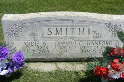
Ardis W. Wilke Smith
| Birth | : | 1 May 1924 Kearney, Buffalo County, Nebraska, USA |
| Death | : | 2 Feb 2013 Lexington, Dawson County, Nebraska, USA |
| Burial | : | Greenwood Cemetery, Lexington, Dawson County, USA |
| Coordinate | : | 40.7956467, -99.7286682 |
| Plot | : | DIV. B , BLOCK 17, LOT 2, SPACE 4. |
| Description | : | Ardis W. Smith, 88, of Lexington, Nebraska, passed away Saturday, February 2, 2013, at Lexington Regional Health Center. She was born May 1, 1924, in Kearney, Nebraska, to Harry and Dortha (Bowen) Wilke. Ardis was a 1941 graduate of Wood River High School. She then went onto further her education at Kearney State Teacher's College. She taught for a time in rural schools and Morton Elementary in Lexington. Ardis was united in marriage to G. Hanford Smith on April 6, 1947, at the United Methodist Church in Lexington. Four children were blessed to this marriage; Sheryl, Susan, Steve and Sally.... Read More |
frequently asked questions (FAQ):
-
Where is Ardis W. Wilke Smith's memorial?
Ardis W. Wilke Smith's memorial is located at: Greenwood Cemetery, Lexington, Dawson County, USA.
-
When did Ardis W. Wilke Smith death?
Ardis W. Wilke Smith death on 2 Feb 2013 in Lexington, Dawson County, Nebraska, USA
-
Where are the coordinates of the Ardis W. Wilke Smith's memorial?
Latitude: 40.7956467
Longitude: -99.7286682
Family Members:
Flowers:


Nearby Cemetories:
1. First United Methodist Church Columbarium
Lexington, Dawson County, USA
Coordinate: 40.7810000, -99.7397000
2. Saint Anns Cemetery
Lexington, Dawson County, USA
Coordinate: 40.7789001, -99.7114029
3. Evergreen Cemetery
Lexington, Dawson County, USA
Coordinate: 40.7639008, -99.6791992
4. Mount Hope Cemetery
Dawson County, USA
Coordinate: 40.8293991, -99.6733017
5. Hewitt Cemetery
Lexington, Dawson County, USA
Coordinate: 40.8588982, -99.7769012
6. Buffalo Grove Presbyterian Church Cemetery
Buffalo, Dawson County, USA
Coordinate: 40.8721000, -99.8270000
7. Hillside Cemetery
Dawson County, USA
Coordinate: 40.8946991, -99.7869034
8. Grace Cemetery
Cozad, Dawson County, USA
Coordinate: 40.8602982, -99.8644028
9. Robb Cemetery
Smithfield, Gosper County, USA
Coordinate: 40.6710691, -99.6996001
10. Saint Johns Lutheran Cemetery
Lexington, Dawson County, USA
Coordinate: 40.9019012, -99.8458023
11. Plum Creek Massacre Cemetery
Phelps County, USA
Coordinate: 40.6726840, -99.6058220
12. Overton Cemetery
Overton, Dawson County, USA
Coordinate: 40.7317009, -99.5222015
13. Cozad Cemetery
Cozad, Dawson County, USA
Coordinate: 40.8605995, -99.9475021
14. Quakerville Cemetery
Gosper County, USA
Coordinate: 40.6189003, -99.8097000
15. Cottonwood Cemetery
Dawson County, USA
Coordinate: 40.9322014, -99.9197006
16. Saint Patricks Cemetery
Eddyville, Dawson County, USA
Coordinate: 40.9747009, -99.6093979
17. Adullam Cemetery
Bertrand, Phelps County, USA
Coordinate: 40.6265000, -99.5856000
18. Fairview Cemetery
Dawson County, USA
Coordinate: 40.7719002, -99.9955978
19. Jewell Cemetery
Sumner, Dawson County, USA
Coordinate: 40.9599991, -99.5646973
20. Rose Hill Cemetery
Dawson County, USA
Coordinate: 40.9888992, -99.8442001
21. Elwood Cemetery
Elwood, Gosper County, USA
Coordinate: 40.5999300, -99.8397300
22. Rhinehart Cemetery
Cozad, Dawson County, USA
Coordinate: 40.9599000, -99.9105000
23. Buffalo First Lutheran Cemetery Old
Buffalo, Dawson County, USA
Coordinate: 41.0100000, -99.8152000
24. Buffalo First Lutheran Cemetery New
Buffalo, Dawson County, USA
Coordinate: 41.0127000, -99.8150000