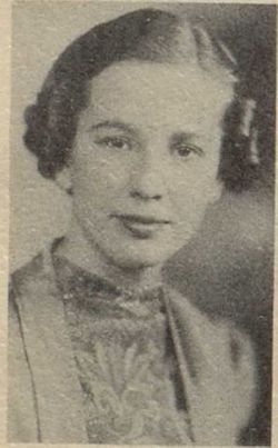
Arlene H. “Hettie” Walker Shutt VanAusdall
| Birth | : | 28 Feb 1921 Yarmouth, Des Moines County, Iowa, USA |
| Death | : | 19 Apr 2005 Iowa City, Johnson County, Iowa, USA |
| Burial | : | St. Andrew's Churchyard, Aldborough, Harrogate Borough, England |
| Coordinate | : | 54.0921790, -1.3809300 |
| Plot | : | I-0607 |
| Inscription | : | HIS WIFE |
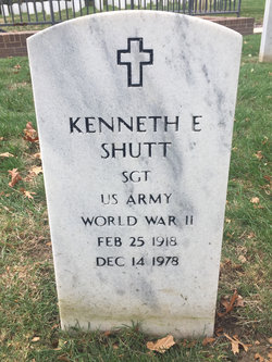
| Description | : | Arlene W. VanAusdall 84, of Keokuk, died on Tuesday, April 19, at Mercy Hospital in Iowa City. She was born on February 28, 1921, in Yarmouth, the daughter of Edger and Daisy Sams Walker. She married Kenneth Shutt on April 2, 1944. He preceded her in death on Dec. 14, 1978. She married C. Max Laubersheimer on Aug. 10, 1985. He preceded her in death on July 6, 1994. On March 12, 1995, she married Howard VanAusdall. She graduated from Mediapolis Consolidated Schools in Mediapolis in 1938. She attended business school in Denver, Colo. She operated Shutts Radiator-Auto Repair and Sales... Read More |
frequently asked questions (FAQ):
-
Where is Arlene H. “Hettie” Walker Shutt VanAusdall's memorial?
Arlene H. “Hettie” Walker Shutt VanAusdall's memorial is located at: St. Andrew's Churchyard, Aldborough, Harrogate Borough, England.
-
When did Arlene H. “Hettie” Walker Shutt VanAusdall death?
Arlene H. “Hettie” Walker Shutt VanAusdall death on 19 Apr 2005 in Iowa City, Johnson County, Iowa, USA
-
Where are the coordinates of the Arlene H. “Hettie” Walker Shutt VanAusdall's memorial?
Latitude: 54.0921790
Longitude: -1.3809300
Family Members:
Parent
Spouse
Siblings
Children
Flowers:
Nearby Cemetories:
1. St. Andrew's Churchyard
Aldborough, Harrogate Borough, England
Coordinate: 54.0921790, -1.3809300
2. Aldborough Cemetery
Aldborough, Harrogate Borough, England
Coordinate: 54.0887207, -1.3843854
3. St James Churchyard
Boroughbridge, Harrogate Borough, England
Coordinate: 54.0929860, -1.3945270
4. Boroughbridge Cemetery
Boroughbridge, Harrogate Borough, England
Coordinate: 54.0905100, -1.3975300
5. All Saints Churchyard
Kirby Hill, Harrogate Borough, England
Coordinate: 54.1116730, -1.4007950
6. St Mary Churchyard
Roecliff, Harrogate Borough, England
Coordinate: 54.0883540, -1.4261620
7. St Mary Churchyard
Myton-on-Swale, Hambleton District, England
Coordinate: 54.0937940, -1.3300540
8. St Mary Churchyard
Lower Dunsforth, Harrogate Borough, England
Coordinate: 54.0777130, -1.3241810
9. Marton-cum-Grafton Cemetery
Marton, Harrogate Borough, England
Coordinate: 54.0549100, -1.3647800
10. St Peter Churchyard
Brafferton, Hambleton District, England
Coordinate: 54.1252600, -1.3337300
11. Christ the Consoler Churchyard
Skelton, Harrogate Borough, England
Coordinate: 54.1059760, -1.4508880
12. St Helen Churchyard
Skelton, Harrogate Borough, England
Coordinate: 54.1095070, -1.4489870
13. St. Bartholomew's Churchyard
Arkendale, Harrogate Borough, England
Coordinate: 54.0435150, -1.4077510
14. All Saints Churchyard
Staveley, Harrogate Borough, England
Coordinate: 54.0585700, -1.4475990
15. St Bartholomew Churchyard
Arkendale, Harrogate Borough, England
Coordinate: 54.0432303, -1.4100916
16. St Mary the Virgin Churchyard
Great Ouseburn, Harrogate Borough, England
Coordinate: 54.0488052, -1.3125230
17. St Michael and All Angels Churchyard
Copgrove, Harrogate Borough, England
Coordinate: 54.0638930, -1.4721140
18. St Stephen Churchyard
Aldwark, Hambleton District, England
Coordinate: 54.0640600, -1.2875000
19. St. Mary and All Saints Churchyard
Cundall, Harrogate Borough, England
Coordinate: 54.1518340, -1.3542490
20. Holy Trinity Churchyard
Little Ouseburn, Harrogate Borough, England
Coordinate: 54.0440712, -1.3101200
21. Dishforth Cemetery
Dishforth, Harrogate Borough, England
Coordinate: 54.1561350, -1.4115950
22. St. John the Baptist Churchyard
Bishop Monkton, Harrogate Borough, England
Coordinate: 54.0885430, -1.4988680
23. St Leonard Churchyard
Burton Leonard, Harrogate Borough, England
Coordinate: 54.0697660, -1.5005160
24. St Oswald Churchyard
Farnham, Harrogate Borough, England
Coordinate: 54.0398420, -1.4698910


