
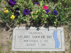


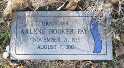
Arlene Hooker Fay
| Birth | : | 21 Nov 1933 Great Falls, Cascade County, Montana, USA |
| Death | : | 7 Aug 2001 Great Falls, Cascade County, Montana, USA |
| Burial | : | Tottington Road Methodist Church Churchyard, Harwood, Metropolitan Borough of Bolton, England |
| Coordinate | : | 53.6079190, -2.3904960 |
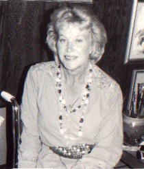
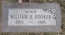
| Description | : | Arlene Hooker Fay was born November 21, 1933 in Great Falls, Montana. Her parents were William and Esther Hooker. Her father was a captain of the Great Falls Fire Department for 33 years and her mother was a cook at the Malmstrom Air Force Base officers club. Arlene was meant to be an artist. From the time she was three years old she would draw faces over and over again. Then she would add bodies and draw people. In grade school she earned nickels and dimes creating paper dolls and designing their clothing. In fifth grade one teacher suggested... Read More |
frequently asked questions (FAQ):
-
Where is Arlene Hooker Fay's memorial?
Arlene Hooker Fay's memorial is located at: Tottington Road Methodist Church Churchyard, Harwood, Metropolitan Borough of Bolton, England.
-
When did Arlene Hooker Fay death?
Arlene Hooker Fay death on 7 Aug 2001 in Great Falls, Cascade County, Montana, USA
-
Where are the coordinates of the Arlene Hooker Fay's memorial?
Latitude: 53.6079190
Longitude: -2.3904960
Family Members:
Parent
Spouse
Siblings
Flowers:


Nearby Cemetories:
1. Tottington Road Methodist Church Churchyard
Harwood, Metropolitan Borough of Bolton, England
Coordinate: 53.6079190, -2.3904960
2. Harwood Methodist Church Cemetery
Harwood, Metropolitan Borough of Bolton, England
Coordinate: 53.6028240, -2.3903990
3. St. Maxentius Churchyard
Bradshaw, Metropolitan Borough of Bolton, England
Coordinate: 53.6056800, -2.4014800
4. Christ Church Churchyard
Harwood, Metropolitan Borough of Bolton, England
Coordinate: 53.5948860, -2.3821990
5. Congregational Churchyard
Affetside, Metropolitan Borough of Bury, England
Coordinate: 53.6175200, -2.3705800
6. St James Churchyard
Breightmet, Metropolitan Borough of Bolton, England
Coordinate: 53.5824000, -2.3922100
7. St Paul Churchyard
Astley Bridge, Metropolitan Borough of Bolton, England
Coordinate: 53.5996230, -2.4314330
8. Ainsworth Methodist Churchyard
Ainsworth, Metropolitan Borough of Bury, England
Coordinate: 53.5877390, -2.3623810
9. Ainsworth Unitarian Chapel Cemetery
Metropolitan Borough of Bury, England
Coordinate: 53.5882700, -2.3590390
10. Hawkshaw Methodist Church Cemetery
Hawkshaw, Metropolitan Borough of Bury, England
Coordinate: 53.6313490, -2.3674190
11. Christ Church Churchyard
Ainsworth, Metropolitan Borough of Bury, England
Coordinate: 53.5875690, -2.3589540
12. St Mary Churchyard
Hawkshaw, Metropolitan Borough of Bury, England
Coordinate: 53.6307270, -2.3636210
13. Bolton Cemetery
Astley Bridge, Metropolitan Borough of Bolton, England
Coordinate: 53.5989150, -2.4370830
14. St. Anne's Churchyard
Chapeltown, Blackburn with Darwen Unitary Authority, England
Coordinate: 53.6371710, -2.4030440
15. St Anne Churchyard
Tottington, Metropolitan Borough of Bury, England
Coordinate: 53.6161499, -2.3409030
16. St. John's Churchyard
Tottington, Metropolitan Borough of Bury, England
Coordinate: 53.6141180, -2.3400670
17. Tonge Cemetery
Bolton, Metropolitan Borough of Bolton, England
Coordinate: 53.5782250, -2.4097050
18. Christ Church Churchyard
Egerton, Metropolitan Borough of Bolton, England
Coordinate: 53.6237080, -2.4389210
19. All Saints Churchyard
Bolton, Metropolitan Borough of Bolton, England
Coordinate: 53.5819700, -2.4271400
20. Bridge Street Wesleyan Methodist Chapel
Bolton, Metropolitan Borough of Bolton, England
Coordinate: 53.5825197, -2.4285839
21. St Peter Churchyard
Bolton, Metropolitan Borough of Bolton, England
Coordinate: 53.5794060, -2.4235690
22. Methodist Church Churchyard
Edgworth, Blackburn with Darwen Unitary Authority, England
Coordinate: 53.6424280, -2.3962830
23. St George Churchyard
Bolton, Metropolitan Borough of Bolton, England
Coordinate: 53.5821900, -2.4305880
24. Greenmount United Reformed Churchyard
Greenmount, Metropolitan Borough of Bury, England
Coordinate: 53.6254581, -2.3381465