
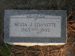
Arminta Josephine “Minta” Smith Stinnette
| Birth | : | 30 Sep 1865 Michigan, USA |
| Death | : | 17 May 1945 Enders, Chase County, Nebraska, USA |
| Burial | : | Jefferson Cemetery, Jefferson, Greene County, USA |
| Coordinate | : | 42.0133018, -94.3591995 |
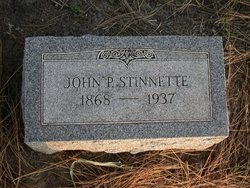
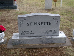
| Description | : | Arminta Josephine (Minta) Smith was born on 30 Sep 1865 in MI. She died on 17 May 1945 in Enders, Chase County, Nebraska, USA. Minta Smith and Pleasant Stinnette were married on 2 Oct 1889. John Pleasant (Pleasant) Stinnette (son of Edward Thomas (Thomas) Stinnette and Lively Elizabeth (Elizabeth) Morris) was born on 20 Mar 1868 in Maries County, Missouri, USA. He died on 6 Dec 1937 in Enders, Chase County, Nebraska, USA. They had the following children: I. Jesse Edward Stinnette was born on 1 Nov 1890 in Omaha, Douglas County, Nebraska, USA. ... Read More |
frequently asked questions (FAQ):
-
Where is Arminta Josephine “Minta” Smith Stinnette's memorial?
Arminta Josephine “Minta” Smith Stinnette's memorial is located at: Jefferson Cemetery, Jefferson, Greene County, USA.
-
When did Arminta Josephine “Minta” Smith Stinnette death?
Arminta Josephine “Minta” Smith Stinnette death on 17 May 1945 in Enders, Chase County, Nebraska, USA
-
Where are the coordinates of the Arminta Josephine “Minta” Smith Stinnette's memorial?
Latitude: 42.0133018
Longitude: -94.3591995
Family Members:
Parent
Spouse
Siblings
Children

Flowers:


Nearby Cemetories:
1. Jefferson Cemetery
Jefferson, Greene County, USA
Coordinate: 42.0133018, -94.3591995
2. Saint Joseph Cemetery
Jefferson, Greene County, USA
Coordinate: 42.0289001, -94.3818970
3. Taylor Cemetery
Greene County, USA
Coordinate: 41.9659000, -94.3333000
4. Headley Cemetery
Jefferson, Greene County, USA
Coordinate: 42.0041504, -94.4335815
5. Pleasant Hill Cemetery
Greene County, USA
Coordinate: 41.9674832, -94.2977430
6. Wright Cemetery
Jefferson, Greene County, USA
Coordinate: 42.0228004, -94.4477997
7. Fair Oaks Cemetery
Scranton, Greene County, USA
Coordinate: 42.0355988, -94.4460983
8. Junction Township Cemetery
Grand Junction, Greene County, USA
Coordinate: 42.0236015, -94.2593994
9. Davis Pioneer Cemetery
Winkelmans, Greene County, USA
Coordinate: 41.9513060, -94.2899320
10. Franklin Township Cemetery
Cooper, Greene County, USA
Coordinate: 41.9268990, -94.3388977
11. Mount Calvary Cemetery
Grand Junction, Greene County, USA
Coordinate: 42.0266000, -94.2325000
12. German Cemetery
Greene County, USA
Coordinate: 41.9136009, -94.3778000
13. Gibson-Fleck-Thompson Cemetery
Scranton, Greene County, USA
Coordinate: 42.0428870, -94.4988800
14. Greenbrier Cemetery
Cooper, Greene County, USA
Coordinate: 41.9063988, -94.4218979
15. Old Franklin Township Cemetery
Greene County, USA
Coordinate: 41.9085000, -94.2850000
16. Old Rippey Cemetery
Rippey, Greene County, USA
Coordinate: 41.9210000, -94.2570000
17. Saint Mary's Cemetery
Cooper, Greene County, USA
Coordinate: 41.8780000, -94.3155000
18. Rippey Cemetery
Rippey, Greene County, USA
Coordinate: 41.9215000, -94.2020000
19. Dawson Cemetery
Paton, Greene County, USA
Coordinate: 42.1655998, -94.3283005
20. Highland Township Cemetery
Churdan, Greene County, USA
Coordinate: 42.1518310, -94.4699120
21. Beaver Cemetery
Beaver, Boone County, USA
Coordinate: 42.0462000, -94.1446000
22. Scranton Township Cemetery
Scranton, Greene County, USA
Coordinate: 42.0306015, -94.5783005
23. Paton Cemetery
Paton, Greene County, USA
Coordinate: 42.1624985, -94.2433014
24. Richland Memorial Cemetery
Herndon, Guthrie County, USA
Coordinate: 41.8353004, -94.3657990