
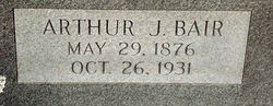
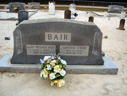
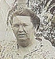
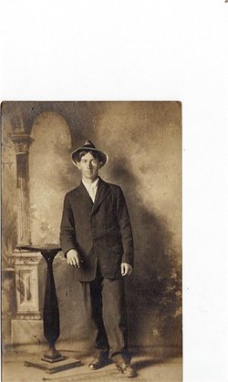
Arthur Judson Bair
| Birth | : | 29 May 1876 Orangeburg County, South Carolina, USA |
| Death | : | 26 Oct 1931 South Carolina, USA |
| Burial | : | Mount Tabor Cemetery, Bowman, Orangeburg County, USA |
| Coordinate | : | 33.2668991, -80.6975021 |
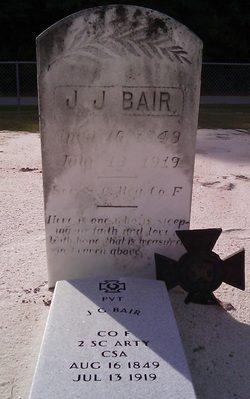
| Description | : | 'Bowman, Oct. 27. - Arthur J. Bair, age 55, died at his home Monday morning after many years of illness. He has been confined to bed for the past nine weeks. He saw services in Cuba during the Spanish American war, and was with Co. G, Second South Carolina Regiment. He is survived by his wife, Mary Reeves Bair, and two sons; R. B. Bair, Bowman; and James J. Bair, Columbia. Three sisters, two brothers and scores of friends mourn his death also. Funeral services were conducted Tuesday 11 A.M. at Mt. Tabor Baptist church by Rev. Cowherd and... Read More |
frequently asked questions (FAQ):
-
Where is Arthur Judson Bair's memorial?
Arthur Judson Bair's memorial is located at: Mount Tabor Cemetery, Bowman, Orangeburg County, USA.
-
When did Arthur Judson Bair death?
Arthur Judson Bair death on 26 Oct 1931 in South Carolina, USA
-
Where are the coordinates of the Arthur Judson Bair's memorial?
Latitude: 33.2668991
Longitude: -80.6975021
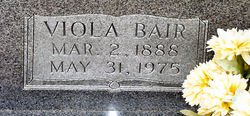
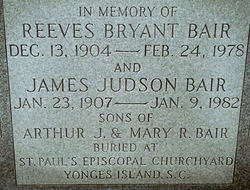
Family Members:
Parent
Spouse
Siblings

Children

Flowers:


Nearby Cemetories:
1. Mount Tabor Cemetery
Bowman, Orangeburg County, USA
Coordinate: 33.2668991, -80.6975021
2. Rigby Cemetery
Bowman, Orangeburg County, USA
Coordinate: 33.2569008, -80.6791992
3. John Berry Cemetery
Branchville, Orangeburg County, USA
Coordinate: 33.2687250, -80.7375060
4. Thompson Cemetery
Branchville, Orangeburg County, USA
Coordinate: 33.2358017, -80.7142029
5. Abraham Berry Cemetery
Branchville, Orangeburg County, USA
Coordinate: 33.3018920, -80.7343960
6. Mount Pisgah Baptist Church
Branchville, Orangeburg County, USA
Coordinate: 33.2167700, -80.7254840
7. Wiles Family Cemetery
Branchville, Orangeburg County, USA
Coordinate: 33.3098800, -80.7399000
8. Mount Pisgah Baptist Church Cemetery
Reevesville, Dorchester County, USA
Coordinate: 33.2164320, -80.7260680
9. Phillips Cemetery
Branchville, Orangeburg County, USA
Coordinate: 33.2477260, -80.7614030
10. Sandy Run Cemetery
Bowman, Orangeburg County, USA
Coordinate: 33.3211000, -80.7201160
11. New Covenant United Methodist Church Cemetery
Bowman, Orangeburg County, USA
Coordinate: 33.3218340, -80.7205080
12. Bryant-Reeves Cemetery
Reevesville, Dorchester County, USA
Coordinate: 33.2086210, -80.6871830
13. Elmore Brand Cemetery
Reevesville, Dorchester County, USA
Coordinate: 33.2442330, -80.6324480
14. Edwards Cemetery #2
Branchville, Orangeburg County, USA
Coordinate: 33.3065330, -80.7529640
15. Bowman Family Cemetery
Bowman, Orangeburg County, USA
Coordinate: 33.3265540, -80.6767090
16. McBranch Baptist Church Cemetery
Orangeburg, Orangeburg County, USA
Coordinate: 33.2308420, -80.7630910
17. Dukes Family Cemetery
Rowesville, Orangeburg County, USA
Coordinate: 33.3194000, -80.7448320
18. Summers Cemetery
Orangeburg County, USA
Coordinate: 33.3185997, -80.7506027
19. Bethel Cemetery
Reevesville, Dorchester County, USA
Coordinate: 33.2075005, -80.6572037
20. Antioch Baptist Church Cemetery #1
Bowman, Orangeburg County, USA
Coordinate: 33.3308260, -80.6649660
21. Saint Mark United Methodist Church Cemetery
Reevesville, Dorchester County, USA
Coordinate: 33.2427970, -80.6195220
22. Rev. John Rhoad Cemetery
Branchville, Orangeburg County, USA
Coordinate: 33.2807840, -80.7791470
23. Cattle Creek Cemetery
Rowesville, Orangeburg County, USA
Coordinate: 33.3224983, -80.7510986
24. Reevesville Baptist Church Cemetery
Reevesville, Dorchester County, USA
Coordinate: 33.2074080, -80.6457490