
| Birth | : | 29 Aug 1910 Park, Gove County, Kansas, USA |
| Death | : | 27 Apr 2000 Hoxie, Sheridan County, Kansas, USA |
| Burial | : | Saint Frances Cemetery, Hoxie, Sheridan County, USA |
| Coordinate | : | 39.3541985, -100.4597015 |
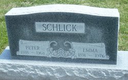
| Description | : | Gove County Advocate, May 3, 2000 Balthasar "Bill" Schlick, 89, died Thursday, April 27, 2000, at the Sheridan County Hospital. He was born Aug. 29, 1910, at Park to Peter J. and Emma (Heier) Schlick. He married Rosemary Younger on May 11, 1936 at Grainfield, KS. He was a farmer. They lived on farms near Quinter and south of Park, moving in 1947 to a farm northeast of Hoxie. In 1974, he retired and moved to Hoxie. He was a member of the St. Frances Catholic Church and Knights of Columbus, Hoxie. Survivors include his wife, Hoxie; three sons: Roger, Hoxie; Larry, Colby;... Read More |
frequently asked questions (FAQ):
-
Where is Balthasar “Bill” Schlick's memorial?
Balthasar “Bill” Schlick's memorial is located at: Saint Frances Cemetery, Hoxie, Sheridan County, USA.
-
When did Balthasar “Bill” Schlick death?
Balthasar “Bill” Schlick death on 27 Apr 2000 in Hoxie, Sheridan County, Kansas, USA
-
Where are the coordinates of the Balthasar “Bill” Schlick's memorial?
Latitude: 39.3541985
Longitude: -100.4597015
Family Members:
Parent

Spouse

Siblings
Flowers:


Nearby Cemetories:
1. Saint Frances Cemetery
Hoxie, Sheridan County, USA
Coordinate: 39.3541985, -100.4597015
2. Hoxie Cemetery
Hoxie, Sheridan County, USA
Coordinate: 39.3736000, -100.4421997
3. Immanuel Lutheran Cemetery
Hoxie, Sheridan County, USA
Coordinate: 39.4339600, -100.4791400
4. Saint Martins Cemetery
Seguin, Sheridan County, USA
Coordinate: 39.3396988, -100.5907974
5. Baugher Cemetery
Studley, Sheridan County, USA
Coordinate: 39.3205600, -100.2560800
6. Bow Creek Cemetery
Tasco, Sheridan County, USA
Coordinate: 39.4227982, -100.2564011
7. Selden Cemetery
Selden, Sheridan County, USA
Coordinate: 39.5381012, -100.5541992
8. Adell Cemetery
Selden, Sheridan County, USA
Coordinate: 39.5384700, -100.3387300
9. Menlo Cemetery
Menlo, Thomas County, USA
Coordinate: 39.3713989, -100.7386017
10. Huey Family Cemetery
Colby, Thomas County, USA
Coordinate: 39.2840500, -100.7357900
11. Calvary Cemetery
Leoville, Decatur County, USA
Coordinate: 39.5803200, -100.4613100
12. Studley Cemetery
Studley, Sheridan County, USA
Coordinate: 39.3568993, -100.1631012
13. Bethel Christian Cemetery
Studley, Sheridan County, USA
Coordinate: 39.2334100, -100.2051300
14. Rexford Cemetery
Rexford, Thomas County, USA
Coordinate: 39.4524000, -100.7374400
15. Grainfield Cemetery
Grainfield, Gove County, USA
Coordinate: 39.1180992, -100.4708023
16. Lucerne Cemetery
Lucerne, Sheridan County, USA
Coordinate: 39.4952087, -100.2127304
17. Saint Pauls Catholic Cemetery
Angelus, Sheridan County, USA
Coordinate: 39.1912810, -100.6854250
18. Mount Pleasant Community Cemetery
Studley, Sheridan County, USA
Coordinate: 39.2550011, -100.1635971
19. Sacred Heart Cemetery
Park, Gove County, USA
Coordinate: 39.1147003, -100.3555984
20. West Park Cemetery
Gove County, USA
Coordinate: 39.1107100, -100.3688300
21. Grinnell Cemetery
Grinnell, Gove County, USA
Coordinate: 39.1300011, -100.6352997
22. Immaculate Conception Cemetery
Grinnell, Gove County, USA
Coordinate: 39.1282997, -100.6316986
23. Allison Cemetery
Decatur County, USA
Coordinate: 39.5741997, -100.2480011
24. Dresden Cemetery
Dresden, Decatur County, USA
Coordinate: 39.6293907, -100.4231033