

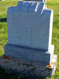
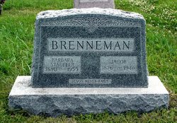
Barbara Stauffer Brenneman
| Birth | : | 1880 |
| Death | : | 6 Jun 1955 |
| Burial | : | Dresden Cemetery, Dresden, Chatham-Kent Municipality, Canada |
| Coordinate | : | 42.5962300, -82.1716500 |
| Plot | : | 098-2 |
| Description | : | (from the obit in MennObits) Gospel Herald Vol 48 #26; 28 Jun 1955 p 624 Brenneman, -- Barbara Elizabeth, daughter of Joseph R. and Mattie (Bender) Stauffer, was born at Milford, Nebr., Oct. 21, 1880; passed away at the Bethel Deaconess Hospital, Newton, Kans., June 2, 1955, after being hospitalized since May 12; aged 74 y. 7 m. 12 d. She was united in marriage on Nov. 15, 1898, to Jacob Brenneman, who preceded her in 1946. Moving from Nebraska, to Tofield, Alta., in 1913, they were among the pioneers of the Salem congregation. In 1943 they moved from Canada to Hesston,... Read More |
frequently asked questions (FAQ):
-
Where is Barbara Stauffer Brenneman's memorial?
Barbara Stauffer Brenneman's memorial is located at: Dresden Cemetery, Dresden, Chatham-Kent Municipality, Canada.
-
When did Barbara Stauffer Brenneman death?
Barbara Stauffer Brenneman death on 6 Jun 1955 in
-
Where are the coordinates of the Barbara Stauffer Brenneman's memorial?
Latitude: 42.5962300
Longitude: -82.1716500
Family Members:
Parent
Spouse
Siblings
Children
Flowers:


Nearby Cemetories:
1. Dresden Cemetery
Dresden, Chatham-Kent Municipality, Canada
Coordinate: 42.5962300, -82.1716500
2. Desmond-Farslow-Traxler Cemetery
Camden, Chatham-Kent Municipality, Canada
Coordinate: 42.6020230, -82.1516970
3. Blackburn Union Burial Grounds
Dresden, Chatham-Kent Municipality, Canada
Coordinate: 42.6011300, -82.1509100
4. British American Institute Cemetery
Dresden, Chatham-Kent Municipality, Canada
Coordinate: 42.5858100, -82.1968700
5. Uncle Tom's Cabin Historic Site
Dresden, Chatham-Kent Municipality, Canada
Coordinate: 42.5845947, -82.1965866
6. Gould Cemetery
Huffs Corners, Lambton County, Canada
Coordinate: 42.6337100, -82.0934440
7. Green Cemetery
Kent Centre, Chatham-Kent Municipality, Canada
Coordinate: 42.5125050, -82.1375630
8. Johnston Cemetery
Croton, Chatham-Kent Municipality, Canada
Coordinate: 42.6085700, -82.0353200
9. Shawbank Cemetery
Kent Bridge, Chatham-Kent Municipality, Canada
Coordinate: 42.5155800, -82.0625300
10. McVicar Cemetery
Darrell, Chatham-Kent Municipality, Canada
Coordinate: 42.4784700, -82.1687700
11. Oldfied United Church Cemetery
Oldfield, Chatham-Kent Municipality, Canada
Coordinate: 42.5423110, -82.3156590
12. Oldfield Methodist Cemetery
Oldfield, Chatham-Kent Municipality, Canada
Coordinate: 42.5422400, -82.3156500
13. Butler Cemetery
Florence, Lambton County, Canada
Coordinate: 42.6367493, -82.0192719
14. Field Cemetery
Chatham-Kent Municipality, Canada
Coordinate: 42.4912670, -82.0837330
15. French's Cemetery
Chatham, Chatham-Kent Municipality, Canada
Coordinate: 42.4723070, -82.1779280
16. Bethel Cemetery
Chatham, Chatham-Kent Municipality, Canada
Coordinate: 42.4882400, -82.0872400
17. Little-Mickle Cemetery
Chatham-Kent Municipality, Canada
Coordinate: 42.5979620, -82.3431810
18. Nazrey Negro Cemetery
Chatham, Chatham-Kent Municipality, Canada
Coordinate: 42.4856140, -82.2728380
19. St. Matthew's Anglican Cemetery
Florence, Lambton County, Canada
Coordinate: 42.6519880, -82.0067860
20. Williams Cemetery
Chatham-Kent Municipality, Canada
Coordinate: 42.5177820, -82.0225340
21. Arnold Cemetery
Louisville, Chatham-Kent Municipality, Canada
Coordinate: 42.4638134, -82.1202579
22. Riverview Cemetery
Wallaceburg, Chatham-Kent Municipality, Canada
Coordinate: 42.5972939, -82.3593521
23. Mount Pleasant Cemetery
Thamesville, Chatham-Kent Municipality, Canada
Coordinate: 42.5593600, -81.9893900
24. Saint Paul's Catholic Cemetery
Thamesville, Chatham-Kent Municipality, Canada
Coordinate: 42.5583100, -81.9885200