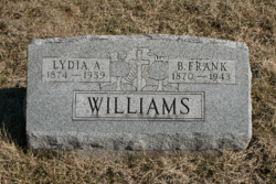
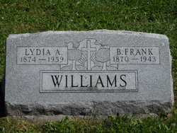
Benjamin Franklin “Frank” Williams
| Birth | : | 3 Nov 1870 Ray County, Missouri, USA |
| Death | : | 23 Jun 1943 Saint Joseph, Buchanan County, Missouri, USA |
| Burial | : | Ollie Cemetery, Ollie, Keokuk County, USA |
| Coordinate | : | 41.1988983, -92.1082993 |
| Plot | : | Section 7 |
| Description | : | MO Death Cert # 20915 Father = George Williams/Missouri Mother = Diddy Meyer Spouse = Mrs. Frank Williams Informant = Arley Williams Occupation = Farmer COD = Endocarditis NOTE: MO Death Cert has birth year listed as 1869. |
frequently asked questions (FAQ):
-
Where is Benjamin Franklin “Frank” Williams's memorial?
Benjamin Franklin “Frank” Williams's memorial is located at: Ollie Cemetery, Ollie, Keokuk County, USA.
-
When did Benjamin Franklin “Frank” Williams death?
Benjamin Franklin “Frank” Williams death on 23 Jun 1943 in Saint Joseph, Buchanan County, Missouri, USA
-
Where are the coordinates of the Benjamin Franklin “Frank” Williams's memorial?
Latitude: 41.1988983
Longitude: -92.1082993
Family Members:
Parent
Spouse
Siblings
Children
Flowers:
Nearby Cemetories:
1. Ollie Cemetery
Ollie, Keokuk County, USA
Coordinate: 41.1988983, -92.1082993
2. Rock Creek Cemetery
Ollie, Keokuk County, USA
Coordinate: 41.1880989, -92.1393967
3. Ollie Brethren Cemetery
Ollie, Keokuk County, USA
Coordinate: 41.2063782, -92.0632183
4. Altman Cemetery
Ollie, Keokuk County, USA
Coordinate: 41.1747017, -92.0733032
5. Halferty Cemetery
Ollie, Keokuk County, USA
Coordinate: 41.1917000, -92.0539017
6. Harris Gravesite
Lancaster, Keokuk County, USA
Coordinate: 41.2420030, -92.1182100
7. Van Orsdall Cemetery
Ollie, Keokuk County, USA
Coordinate: 41.2355995, -92.1564026
8. Brater Cemetery
Lancaster, Keokuk County, USA
Coordinate: 41.2543000, -92.0928000
9. Summit Cemetery
Richland, Keokuk County, USA
Coordinate: 41.1897011, -92.0291977
10. Trueblood Cemetery
Sigourney, Keokuk County, USA
Coordinate: 41.2583462, -92.1501798
11. Prairie Center Cemetery
Packwood, Jefferson County, USA
Coordinate: 41.1264000, -92.0849991
12. Reed Cemetery
Richland Township, Keokuk County, USA
Coordinate: 41.2355995, -92.0216980
13. Blue Point Cemetery
Jefferson County, USA
Coordinate: 41.1618996, -92.0218964
14. Skinner Cemetery
Martinsburg, Keokuk County, USA
Coordinate: 41.2139024, -92.2085143
15. Old Methodist Cemetery
Richland, Keokuk County, USA
Coordinate: 41.1948000, -92.0002000
16. Highland Cemetery
Richland, Keokuk County, USA
Coordinate: 41.1949997, -91.9985962
17. Doggett Cemetery
Keokuk County, USA
Coordinate: 41.2799988, -92.1306000
18. Friends Cemetery
Richland, Keokuk County, USA
Coordinate: 41.1917000, -91.9953003
19. Jones Cemetery
Keokuk County, USA
Coordinate: 41.1984190, -92.2238730
20. Mount Zion Cemetery
Martinsburg, Keokuk County, USA
Coordinate: 41.1988983, -92.2275009
21. Forrest Cemetery
Wapello County, USA
Coordinate: 41.1142006, -92.1793976
22. Forrest Cemetery
Jefferson County, USA
Coordinate: 41.1143000, -92.1797000
23. Garabaldi Cemetery
Sigourney, Keokuk County, USA
Coordinate: 41.3027800, -92.1111100
24. Pennington Cemetery
Sigourney, Keokuk County, USA
Coordinate: 41.2769012, -92.2050018


