
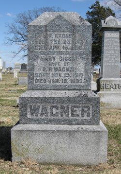
Benjamin Franklin Wagner
| Birth | : | 12 Feb 1814 Montgomery County, Ohio, USA |
| Death | : | 18 Apr 1896 Beloit, Mitchell County, Kansas, USA |
| Burial | : | Saint Pauls Evangelical Lutheran Cemetery, Prairie Farm, Barron County, USA |
| Coordinate | : | 45.2089100, -91.9325420 |
| Description | : | He married (1) Mary C Polly Hunt who died in 1847. He then married (20 Mary Cissne. |
frequently asked questions (FAQ):
-
Where is Benjamin Franklin Wagner's memorial?
Benjamin Franklin Wagner's memorial is located at: Saint Pauls Evangelical Lutheran Cemetery, Prairie Farm, Barron County, USA.
-
When did Benjamin Franklin Wagner death?
Benjamin Franklin Wagner death on 18 Apr 1896 in Beloit, Mitchell County, Kansas, USA
-
Where are the coordinates of the Benjamin Franklin Wagner's memorial?
Latitude: 45.2089100
Longitude: -91.9325420
Family Members:
Parent

Spouse

Siblings
Children
Flowers:


Nearby Cemetories:
1. Saint Pauls Evangelical Lutheran Cemetery
Prairie Farm, Barron County, USA
Coordinate: 45.2089100, -91.9325420
2. Oak Grove Cemetery
Ridgeland, Dunn County, USA
Coordinate: 45.1931000, -91.9266968
3. Vanceburg Cemetery
Dunn County, USA
Coordinate: 45.1899986, -91.9957962
4. Evergreen Cemetery
Prairie Farm, Barron County, USA
Coordinate: 45.2477989, -91.9736023
5. Greenwood Cemetery
Dallas, Barron County, USA
Coordinate: 45.2234180, -91.8605410
6. Sheridan Zion Cemetery
Ridgeland, Dunn County, USA
Coordinate: 45.1502500, -91.9419000
7. Solum Cemetery
Prairie Farm, Barron County, USA
Coordinate: 45.2266998, -92.0136032
8. Akers Cemetery
Prairie Farm, Barron County, USA
Coordinate: 45.2372017, -92.0141983
9. Sunset Cemetery
Prairie Farm, Barron County, USA
Coordinate: 45.2538986, -92.0002975
10. Glenwood Cemetery
Dallas, Barron County, USA
Coordinate: 45.2827988, -91.9103012
11. New Hope Pine Creek Lutheran Cemetery
Ridgeland, Dunn County, USA
Coordinate: 45.1856400, -91.8196400
12. West Akers Lutheran Church Cemetery
Ridgeland, Dunn County, USA
Coordinate: 45.2041100, -92.0689300
13. Saint Pauls Evangelical Lutheran Cemetery
Dallas, Barron County, USA
Coordinate: 45.2908300, -91.8595220
14. Tollebu Cemetery
Ridgeland, Dunn County, USA
Coordinate: 45.1255989, -91.8553009
15. Dallas Cemetery
Dallas, Barron County, USA
Coordinate: 45.2728004, -91.8225021
16. Evergreen Cemetery
Dallas, Barron County, USA
Coordinate: 45.2186012, -91.7782974
17. New Haven Cemetery
Connorsville, Dunn County, USA
Coordinate: 45.1507988, -92.0671997
18. Old Hillsdale Cemetery
Hillsdale, Barron County, USA
Coordinate: 45.3142014, -91.8694000
19. Independent Cemetery
Arland, Barron County, USA
Coordinate: 45.3232994, -92.0132980
20. Upper Popple Creek Cemetery
Ridgeland, Dunn County, USA
Coordinate: 45.1166992, -91.8069000
21. Sioux Creek Cemetery
Dallas, Barron County, USA
Coordinate: 45.2505989, -91.7577972
22. Grace Lutheran Cemetery
Connorsville, Dunn County, USA
Coordinate: 45.1378000, -92.0901000
23. New Scandinavia Lutheran Cemetery
Dallas, Barron County, USA
Coordinate: 45.3014940, -91.7982920
24. Mount Hope Cemetery
Arland, Barron County, USA
Coordinate: 45.3083800, -92.0570400