
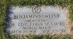

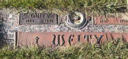
Benjamin Harrison Welty
| Birth | : | 20 Mar 1891 Boone County, Iowa, USA |
| Death | : | 24 Jan 1966 Havre, Hill County, Montana, USA |
| Burial | : | Big Sandy Cemetery, Big Sandy, Chouteau County, USA |
| Coordinate | : | 48.1801170, -110.1207500 |
| Description | : | Additional information provided by Find A Grave contributor "Cara": Havre Daily News (MT), 25 Jan 1966 Welty Dies Benjamin H. Welty, 74, retired Big Sandy farmer and rancher, died Monday in a Havre hospital. Born March 20, 1891, Welty came to Montana in 1914 from his native Boone County, Iowa. On Sept. 30, 1920 he was married to Miss Loetta Hibbard in Great Falls. The couple homesteaded eight miles east of Big Sandy and, except for a short residence in Sacramento, Calif., have farmed near Big Sandy ever since that time. A veteran of World War I, Welty served as... Read More |
frequently asked questions (FAQ):
-
Where is Benjamin Harrison Welty's memorial?
Benjamin Harrison Welty's memorial is located at: Big Sandy Cemetery, Big Sandy, Chouteau County, USA.
-
When did Benjamin Harrison Welty death?
Benjamin Harrison Welty death on 24 Jan 1966 in Havre, Hill County, Montana, USA
-
Where are the coordinates of the Benjamin Harrison Welty's memorial?
Latitude: 48.1801170
Longitude: -110.1207500
Family Members:
Parent
Spouse
Siblings
Children

Flowers:


Nearby Cemetories:
1. Big Sandy Cemetery
Big Sandy, Chouteau County, USA
Coordinate: 48.1801170, -110.1207500
2. Box Elder Cemetery
Box Elder, Hill County, USA
Coordinate: 48.3274000, -110.0095000
3. Kenilworth Cemetery
Chouteau County, USA
Coordinate: 48.2192001, -110.4188995
4. Rocky Boy Cemetery
Rocky Boy, Hill County, USA
Coordinate: 48.2572410, -109.7923690
5. Rocky Boy Gravel Cemetery
Rocky Boy, Hill County, USA
Coordinate: 48.2427720, -109.7596500
6. Cottonwood Lutheran Church Cemetery
Havre, Hill County, USA
Coordinate: 48.4545000, -110.1748000
7. Gildford Hill County Cemetery
Gildford, Hill County, USA
Coordinate: 48.5778008, -110.2957993
8. Clear Lake Cemetery
Chouteau County, USA
Coordinate: 47.7731018, -110.2514038
9. Hingham Union Cemetery
Hingham, Hill County, USA
Coordinate: 48.5601570, -110.4178980
10. Sunset Garden Park
Havre, Hill County, USA
Coordinate: 48.5531006, -109.8019028
11. Graceville Cemetery
Chouteau County, USA
Coordinate: 47.7505989, -110.0875015
12. Hungry Hollow Cemetery
Blaine County, USA
Coordinate: 48.2103004, -109.4677963
13. Highland Cemetery
Havre, Hill County, USA
Coordinate: 48.5463982, -109.6900024
14. Mount Hope Cemetery
Havre, Hill County, USA
Coordinate: 48.5540000, -109.7050000
15. Calvary Cemetery
Havre, Hill County, USA
Coordinate: 48.5457000, -109.6883000
16. Rudyard Cemetery
Rudyard, Hill County, USA
Coordinate: 48.5659500, -110.5390000
17. Riverside Cemetery
Fort Benton, Chouteau County, USA
Coordinate: 47.8402330, -110.6408830
18. Old Shep Gravesite
Fort Benton, Chouteau County, USA
Coordinate: 47.8369000, -110.6557000
19. Milk River Valley Church Graveyard
Hill County, USA
Coordinate: 48.6787180, -110.2261080
20. Museum of the Upper Missouri
Fort Benton, Chouteau County, USA
Coordinate: 47.8207000, -110.6642000
21. Inverness Cemetery
Hill County, USA
Coordinate: 48.5531340, -110.6688450
22. Grainbelt Cemetery
Hill County, USA
Coordinate: 48.6828003, -109.8657990
23. Montague Cemetery
Chouteau County, USA
Coordinate: 47.6783000, -110.4670000
24. North Havre Lutheran Church Graveyard (Defunct)
Havre, Hill County, USA
Coordinate: 48.6538903, -109.6815870