Berryman Kenchin Davis
| Birth | : | 23 Apr 1839 Pettis County, Missouri, USA |
| Death | : | 16 Nov 1876 Maryville, Nodaway County, Missouri, USA |
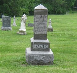
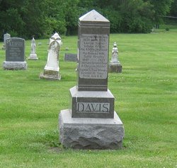
| Burial | : | Mount Benedict Cemetery, West Roxbury, Suffolk County, USA |
| Coordinate | : | 42.2982700, -71.1686600 |
| Plot | : | Northeast (3), Row 7 |
| Inscription | : | Maj. 43 Reg Mo Vol Inf. Sedgwick GAR |
| Description | : | Nodaway Democrat (Maryville, Missouri), Thursday, November 23, 1876 Berryman K. [enchin] Davis was born in Pettis county, Missouri, on the 23d day of April 1839 and consequently was a little over thirty-seven years of age at the time of his death. His parents moved to this county in the spring of 1842 and settled on the White Cloud, a few miles from Maryville. It will thus be seen that the deceased spent most of his life in this immediate vicinity. He came here when but a small boy and with the exception of a few years of temporary absence in... Read More |
frequently asked questions (FAQ):
-
Where is Berryman Kenchin Davis's memorial?
Berryman Kenchin Davis's memorial is located at: Mount Benedict Cemetery, West Roxbury, Suffolk County, USA.
-
When did Berryman Kenchin Davis death?
Berryman Kenchin Davis death on 16 Nov 1876 in Maryville, Nodaway County, Missouri, USA
-
Where are the coordinates of the Berryman Kenchin Davis's memorial?
Latitude: 42.2982700
Longitude: -71.1686600
Family Members:
Parent
Spouse
Siblings
Children
Flowers:
Nearby Cemetories:
1. Mount Benedict Cemetery
West Roxbury, Suffolk County, USA
Coordinate: 42.2982700, -71.1686600
2. Saint Joseph Cemetery
West Roxbury, Suffolk County, USA
Coordinate: 42.2961400, -71.1719200
3. Mount Lebanon Cemetery
West Roxbury, Suffolk County, USA
Coordinate: 42.2933830, -71.1763860
4. Beth El Cemetery
West Roxbury, Suffolk County, USA
Coordinate: 42.2928700, -71.1769800
5. Crawford Street Memorial Park
West Roxbury, Suffolk County, USA
Coordinate: 42.2924000, -71.1780300
6. Shara Tfilo Cemetery
West Roxbury, Suffolk County, USA
Coordinate: 42.2921400, -71.1791400
7. Kopaigorod Cemetery
West Roxbury, Suffolk County, USA
Coordinate: 42.2920200, -71.1793300
8. Puritan Cemetery
West Roxbury, Suffolk County, USA
Coordinate: 42.2916900, -71.1798900
9. Vilno Cemetery
West Roxbury, Suffolk County, USA
Coordinate: 42.2910500, -71.1803900
10. Temple Emeth Memorial Park
West Roxbury, Suffolk County, USA
Coordinate: 42.2907000, -71.1804700
11. Mohliver Cemetery
West Roxbury, Suffolk County, USA
Coordinate: 42.2907200, -71.1806600
12. Lawrence Avenue Cemetery
West Roxbury, Suffolk County, USA
Coordinate: 42.2903800, -71.1809900
13. New Palestine Cemetery
West Roxbury, Suffolk County, USA
Coordinate: 42.2907700, -71.1814500
14. Or Emet Cemetery
West Roxbury, Suffolk County, USA
Coordinate: 42.2901600, -71.1810000
15. Hebrew Rehabilitation Center for Aged Cemetery
West Roxbury, Suffolk County, USA
Coordinate: 42.2901100, -71.1810800
16. Imas-Roxbury Lodge Cemetery
West Roxbury, Suffolk County, USA
Coordinate: 42.2901500, -71.1812200
17. Anshei Sfard Cemetery
West Roxbury, Suffolk County, USA
Coordinate: 42.2900400, -71.1814300
18. Staro Konstantinov Cemetery
West Roxbury, Suffolk County, USA
Coordinate: 42.2897900, -71.1815200
19. Quincy Hebrew Cemetery
West Roxbury, Suffolk County, USA
Coordinate: 42.2897300, -71.1816000
20. Independent Workmens Circle Cemetery
West Roxbury, Suffolk County, USA
Coordinate: 42.2896800, -71.1818600
21. Koretzer Cemetery
West Roxbury, Suffolk County, USA
Coordinate: 42.2895100, -71.1818600
22. Independent Pride of Boston Cemetery
West Roxbury, Suffolk County, USA
Coordinate: 42.2893200, -71.1820900
23. David Vicur Cholim Cemetery
West Roxbury, Suffolk County, USA
Coordinate: 42.2892900, -71.1823700
24. Kehillath Jacob Cemetery
West Roxbury, Suffolk County, USA
Coordinate: 42.2891200, -71.1823200

