
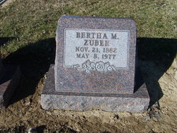

Bertha Mae Roberts Zuber
| Birth | : | 21 Nov 1882 Allen County, Ohio, USA |
| Death | : | 8 May 1977 Fostoria, Seneca County, Ohio, USA |
| Burial | : | Jewish Pioneer Cemetery, Kimberley, Frances Baard District Municipality, South Africa |
| Coordinate | : | -28.7326500, 24.7655760 |
| Inscription | : | Bertha M. Zuber Nov. 21, 1882 May 8, 1977 |
| Description | : | Mrs. Bertha M. Zuber, 94, formerly of Lima, died at 5:30 p.m. Sunday at the Good Shepherd Home in Fostoria. Survivors include a son, Eugene of Fostoria; one grandson and one great-grandchild; a brother, Oliver Roberts of St. Marys; and a sister, Mrs. Gertrude Gardner of Forest Grove, Oregon. Mrs. Zuber was a member of First United Methodist Church of Lima. |
frequently asked questions (FAQ):
-
Where is Bertha Mae Roberts Zuber's memorial?
Bertha Mae Roberts Zuber's memorial is located at: Jewish Pioneer Cemetery, Kimberley, Frances Baard District Municipality, South Africa.
-
When did Bertha Mae Roberts Zuber death?
Bertha Mae Roberts Zuber death on 8 May 1977 in Fostoria, Seneca County, Ohio, USA
-
Where are the coordinates of the Bertha Mae Roberts Zuber's memorial?
Latitude: -28.7326500
Longitude: 24.7655760
Family Members:
Parent
Spouse
Siblings

Children
Flowers:


Nearby Cemetories:
1. Jewish Pioneer Cemetery
Kimberley, Frances Baard District Municipality, South Africa
Coordinate: -28.7326500, 24.7655760
2. Pioneer Cemetery
Kimberley, Frances Baard District Municipality, South Africa
Coordinate: -28.7333553, 24.7657076
3. The Cathedral Church of St Cyprian the Martyr
Kimberley, Frances Baard District Municipality, South Africa
Coordinate: -28.7428330, 24.7703500
4. Gladstone Cemetery
Kimberley, Frances Baard District Municipality, South Africa
Coordinate: -28.7230670, 24.7763170
5. NH Kerk Van Afrika-Kimberley Muur van Herinnering
Kimberley, Frances Baard District Municipality, South Africa
Coordinate: -28.7450364, 24.7549696
6. M.O.T.H. Tuin van Herinnering
Kimberley, Frances Baard District Municipality, South Africa
Coordinate: -28.7519279, 24.7690742
7. West End Cemetery
Kimberley, Frances Baard District Municipality, South Africa
Coordinate: -28.7360400, 24.7375500
8. NG Kerk - Diamantveld Muur van Herinnering
Kimberley, Frances Baard District Municipality, South Africa
Coordinate: -28.7541460, 24.7819791
9. NG Kerk - Vooruitsig Muur van Herinnering
Kimberley, Frances Baard District Municipality, South Africa
Coordinate: -28.7511490, 24.7442646
10. St. Andrew's Presbyterian Church Memorial Wall
Beaconsfield, Frances Baard District Municipality, South Africa
Coordinate: -28.7554717, 24.7815350
11. NG Kerk - Harmonie Muur van Herinnering
Kimberley, Frances Baard District Municipality, South Africa
Coordinate: -28.7620330, 24.7639670
12. NG Kerk - Bakenskop Muur van Herinnering
Kimberley, Frances Baard District Municipality, South Africa
Coordinate: -28.7484330, 24.7260500
13. Galeshewe Cemetery
Vergenoeg, ZF Mgcawu District Municipality, South Africa
Coordinate: -28.7192502, 24.7236642
14. Kenilworth Cemetery
Kenilworth, Frances Baard District Municipality, South Africa
Coordinate: -28.6984830, 24.7913500
15. Dutoitspan Cemetery
Kimberley, Frances Baard District Municipality, South Africa
Coordinate: -28.7540300, 24.8055200
16. Bultfontein Burial Ground
Kimberley, Frances Baard District Municipality, South Africa
Coordinate: -28.7780200, 24.7741800
17. Ramatshela Cemetery
Kimberley, Frances Baard District Municipality, South Africa
Coordinate: -28.7051651, 24.7101328
18. Carters Ridge Monument
Kimberley, Frances Baard District Municipality, South Africa
Coordinate: -28.7467000, 24.6999000
19. Roodepan Cemetery
Kimberley, Frances Baard District Municipality, South Africa
Coordinate: -28.6808856, 24.7301720
20. Galeshewe North Cemetery
Kimberley, Frances Baard District Municipality, South Africa
Coordinate: -28.7085506, 24.6930277
21. Riverton Cemetery
Riverton, Frances Baard District Municipality, South Africa
Coordinate: -28.5231411, 24.6971085
22. Pieter Meintjes Fontein Farm Cemetery
Central Karoo District Municipality, South Africa
Coordinate: -28.9694000, 24.6984670
23. Mataleng Cemetery
Barkly West, Frances Baard District Municipality, South Africa
Coordinate: -28.5291924, 24.5015062
24. Wakeford Road Cemetery
Barkly West, Frances Baard District Municipality, South Africa
Coordinate: -28.5184542, 24.5016843