
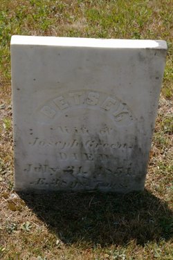
Betsey Turner Green
| Birth | : | 4 Dec 1812 |
| Death | : | 31 Jul 1851 |
| Burial | : | Bell Hill Cemetery, Otisfield, Oxford County, USA |
| Coordinate | : | 44.0883130, -70.5602760 |
| Description | : | She was the daughter of Thaddeus Turner and Lydia Spurr. She married Joseph Green in Otisfield, Maine on April 25, 1838. |
frequently asked questions (FAQ):
-
Where is Betsey Turner Green's memorial?
Betsey Turner Green's memorial is located at: Bell Hill Cemetery, Otisfield, Oxford County, USA.
-
When did Betsey Turner Green death?
Betsey Turner Green death on 31 Jul 1851 in
-
Where are the coordinates of the Betsey Turner Green's memorial?
Latitude: 44.0883130
Longitude: -70.5602760
Family Members:
Spouse
Children
Flowers:


Nearby Cemetories:
1. Elmwood Cemetery
Otisfield, Oxford County, USA
Coordinate: 44.1019630, -70.5504070
2. Wight Cemetery
Otisfield, Oxford County, USA
Coordinate: 44.0890990, -70.5381570
3. Highland Cemetery
Otisfield, Oxford County, USA
Coordinate: 44.1007100, -70.5796200
4. Scribner Hill Cemetery Lower Yard
Otisfield, Oxford County, USA
Coordinate: 44.0769660, -70.5261470
5. East Otisfield Cemetery
Otisfield, Oxford County, USA
Coordinate: 44.0950300, -70.5237500
6. Oakdale Cemetery
Otisfield, Oxford County, USA
Coordinate: 44.1013900, -70.6014500
7. Cobb Hill Cemetery
Otisfield, Oxford County, USA
Coordinate: 44.0746000, -70.5095000
8. Bolster's Mills Cemetery
Harrison, Cumberland County, USA
Coordinate: 44.1171700, -70.5987020
9. Oak Hill Cemetery
Otisfield, Oxford County, USA
Coordinate: 44.0464040, -70.5762640
10. Cedar Crest Cemetery
Otisfield, Oxford County, USA
Coordinate: 44.0442009, -70.5438995
11. Maple Ridge Cemetery
Harrison, Cumberland County, USA
Coordinate: 44.0936012, -70.6278000
12. Richville Cemetery
Oxford, Oxford County, USA
Coordinate: 44.1340390, -70.5226510
13. Carsley Cemetery
Harrison, Cumberland County, USA
Coordinate: 44.0586560, -70.6224610
14. South Harrison Cemetery
Harrison, Cumberland County, USA
Coordinate: 44.0539017, -70.6188965
15. South Otisfield Cemetery
Otisfield, Oxford County, USA
Coordinate: 44.0428560, -70.5131290
16. Merrill Memorial Cemetery
Otisfield, Oxford County, USA
Coordinate: 44.1474250, -70.5608830
17. Stuarts Corner Cemetery
Bolsters Mills, Cumberland County, USA
Coordinate: 44.1417700, -70.5975200
18. Caswells Corner Cemetery
Harrison, Cumberland County, USA
Coordinate: 44.1312003, -70.6191605
19. Ryefield Cemetery
Cumberland County, USA
Coordinate: 44.1417007, -70.5994034
20. Unidentified Cemetery
Harrison, Cumberland County, USA
Coordinate: 44.1222448, -70.6322634
21. Perley Cemetery
Harrison, Cumberland County, USA
Coordinate: 44.1222220, -70.6324794
22. Johnson Cemetery
Harrison, Cumberland County, USA
Coordinate: 44.0638910, -70.6459670
23. Trafton Cemetery
Harrison, Cumberland County, USA
Coordinate: 44.0596910, -70.6436170
24. Summit Hill Cemetery
Harrison, Cumberland County, USA
Coordinate: 44.1269770, -70.6354860