
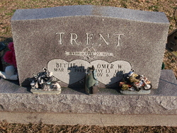
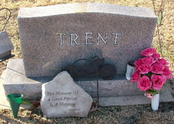
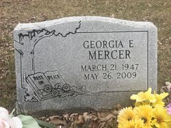
Bettie Jean Chaffins Trent
| Birth | : | 11 Mar 1943 |
| Death | : | 16 Feb 2021 Winamac, Pulaski County, Indiana, USA |
| Burial | : | Tewantin Cemetery, Tewantin, Noosa Shire, Australia |
| Coordinate | : | -26.3950054, 153.0254472 |
| Description | : | Bettie Jean (Chaffins) Trent , age 77 , passed away peacefully on February 16, 2021 at Pulaski Health Care Center Winamac, IN. She was born March 11, 1943 to Estill and Nancy Chaffins. On April 22, 1961 she married Omer Trent in North Judson. He preceded her in death on November 6, 2004. Bettie is survived by her four children, Ronald Trent, Donald Trent, Tina Trent and John Trent. She also has several grandchildren , Randy Trent, Omer Trent, Ronnie Trent, Tiffany Golding , Amanda Short, Kacey Fisher, Kara Trent, and many great grandchildren. She was preceded... Read More |
frequently asked questions (FAQ):
-
Where is Bettie Jean Chaffins Trent's memorial?
Bettie Jean Chaffins Trent's memorial is located at: Tewantin Cemetery, Tewantin, Noosa Shire, Australia.
-
When did Bettie Jean Chaffins Trent death?
Bettie Jean Chaffins Trent death on 16 Feb 2021 in Winamac, Pulaski County, Indiana, USA
-
Where are the coordinates of the Bettie Jean Chaffins Trent's memorial?
Latitude: -26.3950054
Longitude: 153.0254472
Family Members:
Parent

Spouse

Siblings
Flowers:


Nearby Cemetories:
1. Cooroy Cemetery
Cooroy, Noosa Shire, Australia
Coordinate: -26.4095520, 152.9143240
2. Eumundi Cemetery
Eumundi, Sunshine Coast Council, Australia
Coordinate: -26.4913680, 152.9405570
3. Pomona Cemetery
Pomona, Noosa Shire, Australia
Coordinate: -26.3441600, 152.8530740
4. Yandina Cemetery
Yandina, Sunshine Coast Council, Australia
Coordinate: -26.5720000, 152.9570000
5. Kulangoor Lawn Cemetery
Kulangoor, Sunshine Coast Council, Australia
Coordinate: -26.5884880, 152.9647280
6. Nambour Garden Lawn Cemetery
Nambour, Sunshine Coast Council, Australia
Coordinate: -26.6116920, 152.9700810
7. Nambour General Cemetery
Nambour, Sunshine Coast Council, Australia
Coordinate: -26.6156180, 152.9713150
8. Gregson & Weight Chapel & Crematorium
Nambour, Sunshine Coast Council, Australia
Coordinate: -26.6156420, 152.9649380
9. Diddillibah Cemetery
Nambour, Sunshine Coast Council, Australia
Coordinate: -26.6471020, 153.0212960
10. Gheerulla Cemetery
Gheerulla, Sunshine Coast Council, Australia
Coordinate: -26.5538100, 152.7713320
11. Mapleton Cemetery
Mapleton, Sunshine Coast Council, Australia
Coordinate: -26.6241030, 152.8479884
12. Woombye Cemetery
Woombye, Sunshine Coast Council, Australia
Coordinate: -26.6806580, 152.9732640
13. Buderim Lawn Crematorium and Memorial Gardens
Buderim, Sunshine Coast Council, Australia
Coordinate: -26.6800700, 153.0924660
14. Flaxton Cemetery
Flaxton, Sunshine Coast Council, Australia
Coordinate: -26.6617420, 152.8731570
15. Kandanga Cemetery
Kandanga, Gympie Region, Australia
Coordinate: -26.3842440, 152.6888120
16. St Mary's Church
Montville, Sunshine Coast Council, Australia
Coordinate: -26.6879465, 152.8926176
17. Cooloola Coast Crematorium
Monkland, Gympie Region, Australia
Coordinate: -26.2148230, 152.6868250
18. Witta Cemetery
Witta, Sunshine Coast Council, Australia
Coordinate: -26.7061560, 152.8270080
19. Mooloolah General Cemetery
Glenview, Sunshine Coast Council, Australia
Coordinate: -26.7750000, 153.0377780
20. Gympie Cemetery
Gympie, Gympie Region, Australia
Coordinate: -26.1749860, 152.6530570
21. Caloundra Cemetery
Caloundra, Sunshine Coast Council, Australia
Coordinate: -26.7940280, 153.1310910
22. Gregson and Weight Caloundra Memorial Gardens
Caloundra, Sunshine Coast Council, Australia
Coordinate: -26.8007321, 153.1174489
23. Cooloola Coast Cemetery
Cooloola Cove, Gympie Region, Australia
Coordinate: -25.9831920, 152.9677170
24. Australia Zoo
Beerwah, Sunshine Coast Council, Australia
Coordinate: -26.8361140, 152.9615310