
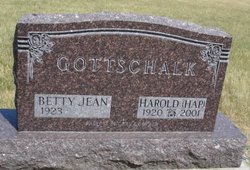
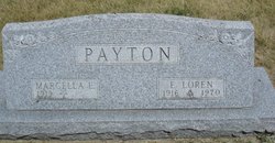
Betty Jean Payton Gottschalk
| Birth | : | 23 Jun 1923 Minburn, Dallas County, Iowa, USA |
| Death | : | 31 May 2017 West Des Moines, Polk County, Iowa, USA |
| Burial | : | Coningsby Cemetery, Coningsby, East Lindsey District, England |
| Coordinate | : | 53.0991060, -0.1774390 |
| Inscription | : | parents of Gary & Gordon |
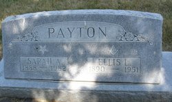
| Description | : | Betty J. Gottschalk West Des Moines Betty Gottschalk, 93, died Wednesday, May 31, 2017 at her home at the Lodge of Ashworth in West Des Moines. Funeral services will be 10 am, Monday, June 5th at Iles Westover Chapel where her family will receive friends one hour prior to the service. Burial will follow at the Greenwood Cemetery in Minburn. Betty was born June 23, 1923 in Minburn to Ellis and Sarah (Thompson) Payton. On November 17, 1944 she married Harold "Hap" Gottschalk. The couple lived in Windsor Heights from 1964 until 1999 when they moved to... Read More |
frequently asked questions (FAQ):
-
Where is Betty Jean Payton Gottschalk's memorial?
Betty Jean Payton Gottschalk's memorial is located at: Coningsby Cemetery, Coningsby, East Lindsey District, England.
-
When did Betty Jean Payton Gottschalk death?
Betty Jean Payton Gottschalk death on 31 May 2017 in West Des Moines, Polk County, Iowa, USA
-
Where are the coordinates of the Betty Jean Payton Gottschalk's memorial?
Latitude: 53.0991060
Longitude: -0.1774390
Family Members:
Parent

Spouse

Siblings
Flowers:


Nearby Cemetories:
1. Coningsby Cemetery
Coningsby, East Lindsey District, England
Coordinate: 53.0991060, -0.1774390
2. St. Michael & All Angels Churchyard
Coningsby, East Lindsey District, England
Coordinate: 53.1055090, -0.1756300
3. Coningsby Baptist Chapelyard
Coningsby, East Lindsey District, England
Coordinate: 53.1086300, -0.1689600
4. Holy Trinity Graveyard
Chapel Hill, North Kesteven District, England
Coordinate: 53.0674300, -0.1999300
5. St. Leonard's Without Churchyard
Kirkstead, East Lindsey District, England
Coordinate: 53.1361800, -0.2224600
6. St. Mary's Churchyard
Kirkby on Bain, East Lindsey District, England
Coordinate: 53.1442900, -0.1430300
7. St Michael Church Cemetery
Billinghay, North Kesteven District, England
Coordinate: 53.0796800, -0.2748100
8. St. Michael and All Angels Churchyard
Billinghay, North Kesteven District, England
Coordinate: 53.0791130, -0.2746370
9. St. Benedict's Churchyard
Haltham, East Lindsey District, England
Coordinate: 53.1571600, -0.1378600
10. All Saints Churchyard
Holland Fen, Boston Borough, England
Coordinate: 53.0346250, -0.1639180
11. Billinghay Cemetery
Billinghay, North Kesteven District, England
Coordinate: 53.0806340, -0.2852800
12. Saint Luke Churchyard
North Kyme, North Kesteven District, England
Coordinate: 53.0591550, -0.2808970
13. St Oswald Churchyard
Walcott, North Kesteven District, England
Coordinate: 53.0945800, -0.3125240
14. St. Oswald Churchyard
Walcott, North Kesteven District, England
Coordinate: 53.0944560, -0.3128500
15. St. Mary and All Saints Churchyard
South Kyme, North Kesteven District, England
Coordinate: 53.0325980, -0.2587880
16. Kyme Priory
North Kyme, North Kesteven District, England
Coordinate: 53.0326000, -0.2589000
17. St. Paul's Churchyard
Carrington, East Lindsey District, England
Coordinate: 53.0783300, -0.0437200
18. St. Margaret Churchyard
Langrick, East Lindsey District, England
Coordinate: 53.0206370, -0.1214770
19. St. Andrew's Churchyard
Timberland, North Kesteven District, England
Coordinate: 53.1095985, -0.3267715
20. St. Andrew's Churchyard
Timberland, North Kesteven District, England
Coordinate: 53.1095985, -0.3267715
21. St. Peter's Churchyard
Frithville, East Lindsey District, England
Coordinate: 53.0380330, -0.0391600
22. St Margarets Churchyard
Langton, East Lindsey District, England
Coordinate: 53.2034275, -0.1490403
23. All Saints Churchyard
Horsington, East Lindsey District, England
Coordinate: 53.2023100, -0.2160600
24. Saint Hippolyte
Saint-Hippolyte, Lloydminster Census Division, Canada
Coordinate: 53.1184742, 0.0000000