
| Birth | : | 11 Aug 1929 Randolph, Cedar County, Nebraska, USA |
| Death | : | 3 Mar 2014 Lincoln, Lancaster County, Nebraska, USA |
| Burial | : | Scranton Township Cemetery, Scranton, Greene County, USA |
| Coordinate | : | 42.0306015, -94.5783005 |
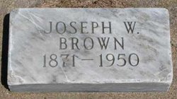
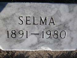
| Description | : | Betty Joy Hight, age 84, of Scranton passed away on Monday, March 3, 2014 at St. Elizabeth Hospital in Lincoln, Nebraska. Born on August 11, 1929 at Randolph, NE, she was the daughter of Joseph and Selma (Becker) Brown. Betty graduated from Randolph High School in 1946 and taught country school for two years. She was married to Neil A. Hight on March 28, 1948 at the United Methodist Church in Glidden. The couple farmed south of Glidden and in Lake City before moving south west of Scranton in 1954. Betty was active in all aspects of their farming operation. She... Read More |
frequently asked questions (FAQ):
-
Where is Betty Joy Brown Hight's memorial?
Betty Joy Brown Hight's memorial is located at: Scranton Township Cemetery, Scranton, Greene County, USA.
-
When did Betty Joy Brown Hight death?
Betty Joy Brown Hight death on 3 Mar 2014 in Lincoln, Lancaster County, Nebraska, USA
-
Where are the coordinates of the Betty Joy Brown Hight's memorial?
Latitude: 42.0306015
Longitude: -94.5783005
Family Members:
Parent
Spouse

Siblings
Flowers:


Nearby Cemetories:
1. Dillavou Cemetery
Kendrick Township, Greene County, USA
Coordinate: 42.0802994, -94.6138992
2. Gibson-Fleck-Thompson Cemetery
Scranton, Greene County, USA
Coordinate: 42.0428870, -94.4988800
3. Wright Cemetery
Jefferson, Greene County, USA
Coordinate: 42.0228004, -94.4477997
4. Fair Oaks Cemetery
Scranton, Greene County, USA
Coordinate: 42.0355988, -94.4460983
5. Headley Cemetery
Jefferson, Greene County, USA
Coordinate: 42.0041504, -94.4335815
6. Dickson Cemetery
Glidden Township, Carroll County, USA
Coordinate: 42.1074982, -94.6939011
7. North Coon Cemetery
Carroll County, USA
Coordinate: 42.1260986, -94.6716995
8. Willow Cemetery
Greene County, USA
Coordinate: 41.9067001, -94.5730972
9. West Lawn Cemetery
Glidden, Carroll County, USA
Coordinate: 42.0649986, -94.7406006
10. Saint Patricks Cemetery
Churdan, Greene County, USA
Coordinate: 42.1605988, -94.5511017
11. Highland Township Cemetery
Churdan, Greene County, USA
Coordinate: 42.1518310, -94.4699120
12. Saint Joseph Cemetery
Jefferson, Greene County, USA
Coordinate: 42.0289001, -94.3818970
13. Union Township Cemetery
Coon Rapids, Carroll County, USA
Coordinate: 41.8781013, -94.6389008
14. Old Cedar Cemetery
Adaza, Greene County, USA
Coordinate: 42.1874821, -94.5419194
15. Old Carrollton Cemetery
Carrollton, Carroll County, USA
Coordinate: 41.9233017, -94.7403030
16. Jefferson Cemetery
Jefferson, Greene County, USA
Coordinate: 42.0133018, -94.3591995
17. Oak Hill Cemetery
Coon Rapids, Carroll County, USA
Coordinate: 41.9053001, -94.7200012
18. McCurdy Cemetery
Carroll County, USA
Coordinate: 41.9403000, -94.7649994
19. Coon Rapids Cemetery
Coon Rapids, Carroll County, USA
Coordinate: 41.8778000, -94.6678009
20. Greenbrier Cemetery
Cooper, Greene County, USA
Coordinate: 41.9063988, -94.4218979
21. Holy Family Cemetery
Lidderdale, Carroll County, USA
Coordinate: 42.1178017, -94.7839966
22. Lanesboro Cemetery
Lanesboro, Carroll County, USA
Coordinate: 42.1810989, -94.7230988
23. Saint Marys Catholic Cemetery
Willey, Carroll County, USA
Coordinate: 41.9783363, -94.8212204
24. East Liberty Cemetery
Lidderdale, Carroll County, USA
Coordinate: 42.1591988, -94.7636032