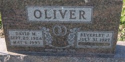
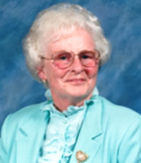
Beverly Jean Hutton Oliver
| Birth | : | 31 Jul 1927 Fort Wayne, Allen County, Indiana, USA |
| Death | : | 24 May 2014 Columbia City, Whitley County, Indiana, USA |
| Burial | : | Berri General Cemetery, Berri, Berri Barmera Council, Australia |
| Coordinate | : | -34.2764387, 140.5888914 |
| Plot | : | 6-2-1-2 |
| Inscription | : | w/o David |
| Description | : | Beverley Jean Oliver, 86, of Columbia City, passed away peacefully on May 24, 2014. The elder daughter of Ray F. and Hazel (Smith) Hutton, Beverley was born July 31, 1927 in the old Lutheran Hospital, Fort Wayne. Her formative years were spent in Whitley County, living in the country on farms and later in Columbia City. She was educated in the Columbia City Schools and Columbia City High School. As a teen, Beverley worked as a "Soda Jerk" at The Klondike Ice Cream Shop in downtown Columbia City. It was there she met her future husband, David M. Oliver. World War II... Read More |
frequently asked questions (FAQ):
-
Where is Beverly Jean Hutton Oliver's memorial?
Beverly Jean Hutton Oliver's memorial is located at: Berri General Cemetery, Berri, Berri Barmera Council, Australia.
-
When did Beverly Jean Hutton Oliver death?
Beverly Jean Hutton Oliver death on 24 May 2014 in Columbia City, Whitley County, Indiana, USA
-
Where are the coordinates of the Beverly Jean Hutton Oliver's memorial?
Latitude: -34.2764387
Longitude: 140.5888914
Family Members:
Flowers:
Nearby Cemetories:
1. Berri General Cemetery
Berri, Berri Barmera Council, Australia
Coordinate: -34.2764387, 140.5888914
2. Bookpurnong Pilgrims of Zion Lutheran Cemetery
Berri, Berri Barmera Council, Australia
Coordinate: -34.3281160, 140.6062620
3. Loxton North Cemetery
Loxton, District Council of Loxton Waikerie, Australia
Coordinate: -34.3939900, 140.6017800
4. Barmera Cemetery
Barmera, Berri Barmera Council, Australia
Coordinate: -34.2642300, 140.4435640
5. Renmark Cemetery
Renmark, Renmark Paringa Council, Australia
Coordinate: -34.1723650, 140.7225840
6. Bugle Hut Lutheran Cemetery
Loxton, District Council of Loxton Waikerie, Australia
Coordinate: -34.3607730, 140.7801570
7. New Residence Trinity Lutheran Church Cemetery
Moorook, District Council of Loxton Waikerie, Australia
Coordinate: -34.3726190, 140.4054430
8. Loxton Cemetery
Loxton, District Council of Loxton Waikerie, Australia
Coordinate: -34.4556160, 140.5714420
9. Stoeckel Family Cemetery
Paringa, Renmark Paringa Council, Australia
Coordinate: -34.1785780, 140.7803160
10. Moorook Cemetery
Moorook, District Council of Loxton Waikerie, Australia
Coordinate: -34.2919660, 140.3523210
11. Paringa Cemetery
Paringa, Renmark Paringa Council, Australia
Coordinate: -34.1628170, 140.7821640
12. Kingston on Murray
Kingston, District Council of Loxton Waikerie, Australia
Coordinate: -34.2330100, 140.3493100
13. Overland Corner Cemetery
Barmera, Berri Barmera Council, Australia
Coordinate: -34.1475900, 140.3426400
14. Myrla Lutheran Cemetery
Wunkar, District Council of Loxton Waikerie, Australia
Coordinate: -34.4513750, 140.3225740
15. Saint Paul's Lutheran Churchyard
Lowbank, District Council of Loxton Waikerie, Australia
Coordinate: -34.1906660, 140.0813100
16. Alawoona Cemetery
Alawoona, District Council of Loxton Waikerie, Australia
Coordinate: -34.7335890, 140.5090860
17. Paruna Cemetery
District Council of Loxton Waikerie, Australia
Coordinate: -34.7251500, 140.7405500
18. Meribah Cemetery
Meribah, District Council of Loxton Waikerie, Australia
Coordinate: -34.7060680, 140.8637590
19. Wanbi Cemetery
Wanbi, District Council of Karoonda East Murray, Australia
Coordinate: -34.7634610, 140.2968910
20. Taplan Saint John Lutheran Cemetery
Taplan, District Council of Loxton Waikerie, Australia
Coordinate: -34.5455690, 140.0000000
21. Galga Cemetery
Waikerie, District Council of Loxton Waikerie, Australia
Coordinate: -34.6889690, 140.0567010
22. Meringur Cemetery
Mildura, Mildura Rural City, Australia
Coordinate: -34.3714000, 141.3343000
23. Cadell Cemetery
Cadell, Mid Murray Council, Australia
Coordinate: -34.0430120, 139.7592360
24. Sandalwood Cemetery
Karoonda, District Council of Karoonda East Murray, Australia
Coordinate: -34.9348120, 140.1251510


