
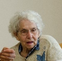
Beverly Mae Letcher Brady
| Birth | : | 1 May 1930 Mitchell, Davison County, South Dakota, USA |
| Death | : | 26 Jun 2012 Sioux Falls, Minnehaha County, South Dakota, USA |
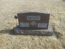
| Burial | : | Union Cemetery, Wakonda, Clay County, USA |
| Coordinate | : | 42.9827995, -97.1222000 |
| Description | : | Beverly Mae Brady, 82, of Wakonda, SD passed away Tuesday, June 26, 2012 at the Avera Heart Hospital in Sioux Falls, SD. Beverly Letcher was born on May 1, 1930 in Mitchell, SD to Charles and Isadore (Hazen) Letcher. She grew up in the Alexandria area and graduated from Alexandria High School. She attended the Mitchel Business School in Mitchel and worked as a bookkeeper for Mitchell Motors from 1950 until 1954. Beverly was united in marriage on February 14, 1954 to Cecil Wayne Brady Jr. Beverly and Cecil owned and operated the Eastside Service "Brady's Station" in Wakonda for many years.... Read More |
frequently asked questions (FAQ):
-
Where is Beverly Mae Letcher Brady's memorial?
Beverly Mae Letcher Brady's memorial is located at: Union Cemetery, Wakonda, Clay County, USA.
-
When did Beverly Mae Letcher Brady death?
Beverly Mae Letcher Brady death on 26 Jun 2012 in Sioux Falls, Minnehaha County, South Dakota, USA
-
Where are the coordinates of the Beverly Mae Letcher Brady's memorial?
Latitude: 42.9827995
Longitude: -97.1222000
Family Members:
Spouse

Flowers:


Nearby Cemetories:
1. Union Cemetery
Wakonda, Clay County, USA
Coordinate: 42.9827995, -97.1222000
2. Volin Cemetery
Volin, Yankton County, USA
Coordinate: 42.9672012, -97.1707993
3. Saint Patricks Catholic Cemetery
Wakonda, Clay County, USA
Coordinate: 42.9672012, -97.0516968
4. New Lodi Cemetery
Lodi, Clay County, USA
Coordinate: 42.9530983, -97.0417023
5. Bethel Baptist Cemetery
Wakonda, Clay County, USA
Coordinate: 42.9393570, -97.0433520
6. Zion Cemetery
Volin, Yankton County, USA
Coordinate: 42.9963300, -97.2234600
7. Saint Columbkill Cemetery
Wakonda, Clay County, USA
Coordinate: 43.0642014, -97.0828018
8. Trondhjem Cemetery
Volin, Yankton County, USA
Coordinate: 43.0325400, -97.2346200
9. Old Lodi Cemetery
Lodi, Clay County, USA
Coordinate: 42.9757996, -96.9907990
10. Gayville Community Cemetery
Gayville, Yankton County, USA
Coordinate: 42.8950005, -97.1800003
11. Pleasant Valley Cemetery
Westerville, Clay County, USA
Coordinate: 42.9247017, -97.0124969
12. Rosenberg Cemetery
Mission Hill, Yankton County, USA
Coordinate: 42.9501090, -97.2596880
13. Hillcrest Cemetery
Yankton County, USA
Coordinate: 43.0835991, -97.1680984
14. Mortvedt Cemetery
Clay County, USA
Coordinate: 42.9169006, -97.0028000
15. Pioneer Cemetery
Yankton County, USA
Coordinate: 43.0758018, -97.2118988
16. Salem Cemetery
Yankton County, USA
Coordinate: 43.0830180, -97.2090590
17. Vangen Church Cemetery
Mission Hill, Yankton County, USA
Coordinate: 42.9260120, -97.2650100
18. CJ Anderson Homestead
Riverside Township, Clay County, USA
Coordinate: 43.0214180, -96.9675540
19. Riverside-Barton Cemetery
Clay County, USA
Coordinate: 43.0402985, -96.9725037
20. Mission Hill Congregational Cemetery
Mission Hill, Yankton County, USA
Coordinate: 42.9247900, -97.2795370
21. Holland Cemetery
Centerville, Turner County, USA
Coordinate: 43.1114006, -97.0314026
22. Hansen Cemetery
Turner County, USA
Coordinate: 43.1260986, -97.1511002
23. Walshtown Catholic Cemetery
Mission Hill, Yankton County, USA
Coordinate: 43.0105500, -97.3208300
24. Walshtown Cemetery
Yankton County, USA
Coordinate: 43.0393982, -97.3094025