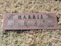
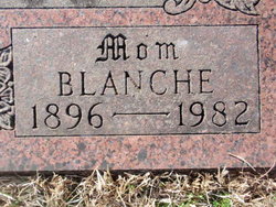
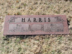
Blanche McDaniel Harris
| Birth | : | 20 Oct 1896 Carrollton, Carroll County, Missouri, USA |
| Death | : | Jun 1982 Pittsburg, Crawford County, Kansas, USA |
| Burial | : | Lutheran Cemetery, Leola, McPherson County, USA |
| Coordinate | : | 45.7235300, -99.2634100 |
| Description | : | Obituary, Source Unknown, 1982: Blanche Harris, 85, of 217 West 24th, died at 4:07 a.m. Tuesday, June 29, 1982, at Mt. Carmel Medical Center. She entered the hospital on Sunday. She was born October 20, 1896, in Carrolton [sic], Missouri, to Luther and Myrtle Gaither McDaniel. She came to Pittsburg from Missouri 83 years ago and had lived here since then. Mrs. Harris married Otis H. Harris, December 28, 1915, in Bowling Green, Missouri. He died March 4, 1960, in Pittsburg. She had worked at the Kansas Ordnance Plant at Parsons and at the Plaza Bakery. She was a member of the Grace Methodist... Read More |
frequently asked questions (FAQ):
-
Where is Blanche McDaniel Harris's memorial?
Blanche McDaniel Harris's memorial is located at: Lutheran Cemetery, Leola, McPherson County, USA.
-
When did Blanche McDaniel Harris death?
Blanche McDaniel Harris death on Jun 1982 in Pittsburg, Crawford County, Kansas, USA
-
Where are the coordinates of the Blanche McDaniel Harris's memorial?
Latitude: 45.7235300
Longitude: -99.2634100
Family Members:
Spouse
Children
Flowers:
Nearby Cemetories:
1. Lutheran Cemetery
Leola, McPherson County, USA
Coordinate: 45.7235300, -99.2634100
2. Leola Cemetery
Leola, McPherson County, USA
Coordinate: 45.7237000, -99.2107500
3. Rueb Cemetery
McPherson County, USA
Coordinate: 45.7097600, -99.2023600
4. Congregational Cemetery
Moscow Township, McPherson County, USA
Coordinate: 45.6804200, -99.3089800
5. Emmanuel Lutheran Cemetery
Long Lake, McPherson County, USA
Coordinate: 45.6693600, -99.2427200
6. Arena Valley Cemetery
Arena Township, McPherson County, USA
Coordinate: 45.7516400, -99.1491600
7. Long Lake Baptist Cemetery
Long Lake, McPherson County, USA
Coordinate: 45.8076100, -99.3248200
8. Mohr Cemetery
McPherson County, USA
Coordinate: 45.6220900, -99.3443700
9. Hottman Family Cemetery
Roscoe, Edmunds County, USA
Coordinate: 45.6132220, -99.3455560
10. Calvin Reformed Cemetery
McPherson County, USA
Coordinate: 45.7519200, -99.4489800
11. Bergdorf Cemetery
Long Lake, McPherson County, USA
Coordinate: 45.8570800, -99.3052800
12. Salem Lutheran Cemetery
Long Lake, McPherson County, USA
Coordinate: 45.8600500, -99.2018200
13. Immanuel Lutheran Cemetery
Long Lake, McPherson County, USA
Coordinate: 45.8723800, -99.1801900
14. Glueckstahl Reformed Cemetery
McPherson County, USA
Coordinate: 45.8464400, -99.4286400
15. Congregational Cemetery
McPherson County, USA
Coordinate: 45.6341900, -99.4692600
16. Hertel Cemetery
Hillsview, McPherson County, USA
Coordinate: 45.6729100, -99.5077400
17. Emmanuel Lutheran Cemetery
Long Lake, McPherson County, USA
Coordinate: 45.8969002, -99.1913986
18. Hoffnungs Gemeinde Cemetery
McPherson County, USA
Coordinate: 45.8396988, -99.0650024
19. Aman Family Cemetery
Hillsview, McPherson County, USA
Coordinate: 45.6547100, -99.5108100
20. Hoffnungs Cemetery
McPherson County, USA
Coordinate: 45.8398800, -99.0508100
21. Hoffnungs Hope Lutheran Cemetery
Hosmer, Edmunds County, USA
Coordinate: 45.5433006, -99.3591995
22. Bethany Cemetery
Hosmer, Edmunds County, USA
Coordinate: 45.5750000, -99.4702000
23. Gienger Cemetery
McPherson County, USA
Coordinate: 45.8851500, -99.0741300
24. Saint Joseph Cemetery
Hillsview, McPherson County, USA
Coordinate: 45.6514200, -99.5516400


