
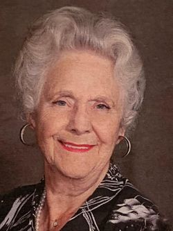
Bonnie Jean Sorensen Kunath
| Birth | : | 24 Feb 1925 Hampton, Franklin County, Iowa, USA |
| Death | : | 26 Dec 2020 Spencer, Clay County, Iowa, USA |
| Burial | : | Riverside Cemetery, Spencer, Clay County, USA |
| Coordinate | : | 43.1441994, -95.1671982 |
| Description | : | Bonnie Jean Sorensen-Kunath was born in Hampton, Iowa February 24th 1925 to Jacob and Christine Rust Sorensen. She spent her childhood years in Latimer, Iowa where she enjoyed the rural community and the Danish traditions of the area. At the age of 14 she and her family moved to Spencer upon her father’s retirement and built the home at 1604 Grand Avenue. Bonnie graduated from Spencer High School in 1943. From there she went on to Iowa state and McMurray college. On June 29th, 1947 Bonnie married Kay Kunath in Spencer. and... Read More |
frequently asked questions (FAQ):
-
Where is Bonnie Jean Sorensen Kunath's memorial?
Bonnie Jean Sorensen Kunath's memorial is located at: Riverside Cemetery, Spencer, Clay County, USA.
-
When did Bonnie Jean Sorensen Kunath death?
Bonnie Jean Sorensen Kunath death on 26 Dec 2020 in Spencer, Clay County, Iowa, USA
-
Where are the coordinates of the Bonnie Jean Sorensen Kunath's memorial?
Latitude: 43.1441994
Longitude: -95.1671982
Family Members:
Parent

Spouse
Siblings

Children
Flowers:


Nearby Cemetories:
1. Riverside Cemetery
Spencer, Clay County, USA
Coordinate: 43.1441994, -95.1671982
2. Dewey Readmore Books Memorial
Spencer, Clay County, USA
Coordinate: 43.1403999, -95.1443024
3. North Lawn Cemetery
Spencer, Clay County, USA
Coordinate: 43.1600000, -95.1470000
4. Evergreen Cemetery
Clay County, USA
Coordinate: 43.2052994, -95.2086029
5. Fairview Cemetery
Clay County, USA
Coordinate: 43.1899986, -95.0800018
6. Swedish Lutheran Cemetery
Royal, Clay County, USA
Coordinate: 43.0683000, -95.2350000
7. Dickens Cemetery
Dickens, Clay County, USA
Coordinate: 43.1280000, -95.0155000
8. Rosehill Cemetery
Clay County, USA
Coordinate: 43.0368996, -95.0919037
9. Lone Tree Cemetery
Everly, Clay County, USA
Coordinate: 43.1411018, -95.3347015
10. Little Sioux Lutheran Cemetery
Milford, Dickinson County, USA
Coordinate: 43.2702065, -95.2109528
11. First Reformed Cemetery
Clay County, USA
Coordinate: 43.2399500, -95.2889000
12. Lincoln Cemetery
Rossie, Clay County, USA
Coordinate: 43.0111008, -95.2313995
13. Willow Creek Cemetery
Royal, Clay County, USA
Coordinate: 43.0214005, -95.2885971
14. Liberty Cemetery
Greenville, Clay County, USA
Coordinate: 42.9897003, -95.1417007
15. Clay Center Cemetery
Royal, Clay County, USA
Coordinate: 43.0410995, -95.3272018
16. Milford Cemetery
Milford, Dickinson County, USA
Coordinate: 43.3092003, -95.1481018
17. TriMello Cemetery
Royal, Clay County, USA
Coordinate: 43.0682983, -95.3728027
18. Logan Township Cemetery
Clay County, USA
Coordinate: 43.0489006, -94.9747009
19. Zion Methodist Cemetery
Clay County, USA
Coordinate: 42.9808006, -95.2497025
20. Calvary Cemetery
Milford, Dickinson County, USA
Coordinate: 43.3213997, -95.1688995
21. Fanny Fern Cemetery
Clay County, USA
Coordinate: 42.9530983, -95.1607971
22. Crown Hill Cemetery
Ruthven, Palo Alto County, USA
Coordinate: 43.1328011, -94.8878021
23. Calvary Cemetery
Ruthven, Palo Alto County, USA
Coordinate: 43.1314011, -94.8869019
24. Westport Cemetery
Dickinson County, USA
Coordinate: 43.3130989, -95.3289032