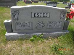
Bonnie June Estes Danner
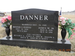
| Birth | : | 18 Dec 1930 Graham, Nodaway County, Missouri, USA |
| Death | : | 9 Oct 2013 Maryville, Nodaway County, Missouri, USA |
| Burial | : | Prairie Home Cemetery, Graham, Nodaway County, USA |
| Coordinate | : | 40.2036018, -95.0488968 |
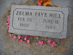
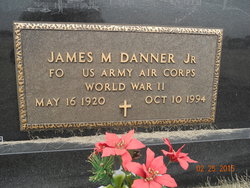
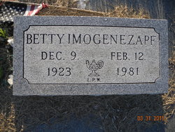
| Description | : | Bonnie June Danner, 82, Maryville, Missouri, died Wednesday, October 9, 2013, at St Francis Hospital, Maryville. Bonnie was born December 18, 1930, in Graham, Missouri to Byron and Zelma Faye (Hill) Estes. A graduate of Maryville High School, Bonnie attended Northwest Missouri State University for two years. Bonnie was a homemaker and a member of the Laura Street Baptist Church, Maryville. She married James Monroe Danner, Jr on December 24, 1949, in Maryville, Missouri. Preceding her in death were her parents, husband James Danner (October 10, 1994), son Jay Scott Danner (September 20, 2008), sisters Betty Zapf, Thelma Kissinger, Dorothy Estes, and brothers Vern... Read More |
frequently asked questions (FAQ):
-
Where is Bonnie June Estes Danner's memorial?
Bonnie June Estes Danner's memorial is located at: Prairie Home Cemetery, Graham, Nodaway County, USA.
-
When did Bonnie June Estes Danner death?
Bonnie June Estes Danner death on 9 Oct 2013 in Maryville, Nodaway County, Missouri, USA
-
Where are the coordinates of the Bonnie June Estes Danner's memorial?
Latitude: 40.2036018
Longitude: -95.0488968
Family Members:
Parent
Spouse
Siblings
Children
Flowers:
Nearby Cemetories:
1. Prairie Home Cemetery
Graham, Nodaway County, USA
Coordinate: 40.2036018, -95.0488968
2. Linville Cemetery
Graham, Nodaway County, USA
Coordinate: 40.2160988, -95.0261002
3. Maitland Cemetery
Maitland, Holt County, USA
Coordinate: 40.2019196, -95.0847015
4. Groves Cemetery
Graham, Nodaway County, USA
Coordinate: 40.2369003, -95.0500031
5. Kyle Cemetery
Graham, Nodaway County, USA
Coordinate: 40.1636009, -95.0307999
6. Schooler Cemetery
Maitland, Holt County, USA
Coordinate: 40.1666985, -95.0903015
7. Shamberger Cemetery
Graham, Nodaway County, USA
Coordinate: 40.1652985, -94.9925003
8. Hillcrest Cemetery
Skidmore, Nodaway County, USA
Coordinate: 40.2689018, -95.0860977
9. Bethany Christian Church Cemetery
Graham, Nodaway County, USA
Coordinate: 40.1585388, -94.9461365
10. Swan Chapel Cemetery
Graham, Nodaway County, USA
Coordinate: 40.2449417, -94.9421692
11. Masonic Cemetery
Skidmore, Nodaway County, USA
Coordinate: 40.2905998, -95.0875015
12. Smith Cemetery
Skidmore, Nodaway County, USA
Coordinate: 40.2971992, -95.0702972
13. Centenary Cemetery
Graham, Nodaway County, USA
Coordinate: 40.1293907, -94.9546204
14. Center District Cemetery
Mound City, Holt County, USA
Coordinate: 40.1743202, -95.1822891
15. Fairview Cemetery
Maitland, Holt County, USA
Coordinate: 40.0943985, -95.0781021
16. North Bethel Cemetery
Mound City, Holt County, USA
Coordinate: 40.2191307, -95.2010753
17. Antioch Christian Church Cemetery
Savannah, Andrew County, USA
Coordinate: 40.0932700, -94.9938600
18. Pleasant Grove Cemetery
Pumpkin Center, Nodaway County, USA
Coordinate: 40.2188110, -94.8918610
19. Cameron Cemetery
Maryville, Nodaway County, USA
Coordinate: 40.3223700, -95.0128700
20. Dysart Cemetery
Andrew County, USA
Coordinate: 40.0934900, -94.9738700
21. Burr Oak Church Cemetery
Skidmore, Nodaway County, USA
Coordinate: 40.2957300, -95.1600500
22. Woodcock Cemetery
Bolckow, Andrew County, USA
Coordinate: 40.0815460, -94.9834260
23. White Cloud Cemetery
Arkoe, Nodaway County, USA
Coordinate: 40.2656700, -94.8940500
24. Salem Cemetery
Pumpkin Center, Nodaway County, USA
Coordinate: 40.2076721, -94.8683167


