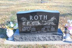
Bonnie Lou Crosby Roth
| Birth | : | 8 Mar 1940 Spalding, Greeley County, Nebraska, USA |
| Death | : | 19 Dec 2019 Centerton, Benton County, Arkansas, USA |
| Burial | : | Sunrise Cemetery, Wahoo, Saunders County, USA |
| Coordinate | : | 41.2050018, -96.5999985 |
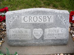
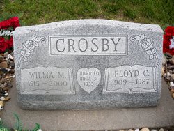
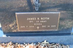
| Description | : | Bonnie was the fourth of nine children born to Floyd and Wilma Crosby, on a farm in Spalding, NE. She attended elementary school in a rural country school near Akron, NE, and high school in Spalding, NE. After graduation, she joined some of her sisters in Omaha where she met her husband Jim Roth at Western Electric. They married on October 8th, 1960 and shared 33 years of marriage until Jim passed away on December 14, 1993. They made their home in Omaha, Millard, and Yutan, NE. Later Bonnie also lived in Bentonville, AR, near her daughter for... Read More |
frequently asked questions (FAQ):
-
Where is Bonnie Lou Crosby Roth's memorial?
Bonnie Lou Crosby Roth's memorial is located at: Sunrise Cemetery, Wahoo, Saunders County, USA.
-
When did Bonnie Lou Crosby Roth death?
Bonnie Lou Crosby Roth death on 19 Dec 2019 in Centerton, Benton County, Arkansas, USA
-
Where are the coordinates of the Bonnie Lou Crosby Roth's memorial?
Latitude: 41.2050018
Longitude: -96.5999985
Family Members:
Parent
Spouse
Siblings
Flowers:
Nearby Cemetories:
1. Sunrise Cemetery
Wahoo, Saunders County, USA
Coordinate: 41.2050018, -96.5999985
2. Sunrise North Cemetery
Wahoo, Saunders County, USA
Coordinate: 41.2062000, -96.5996000
3. Saint Francis Cemetery
Wahoo, Saunders County, USA
Coordinate: 41.2038994, -96.6007996
4. Greenwood Cemetery
Wahoo, Saunders County, USA
Coordinate: 41.2233009, -96.6205978
5. Saint Wenceslaus Cemetery
Wahoo, Saunders County, USA
Coordinate: 41.2350006, -96.6322021
6. Saunders County Poor Farm Cemetery
Wahoo, Saunders County, USA
Coordinate: 41.2473830, -96.6093450
7. Alma Cemetery
Mead, Saunders County, USA
Coordinate: 41.2193985, -96.5214005
8. Indian Mound Cemetery
Ithaca, Saunders County, USA
Coordinate: 41.1619987, -96.5358124
9. Marietta Cemetery
Colon, Saunders County, USA
Coordinate: 41.2786140, -96.5622482
10. Czech Presbyterian Cemetery
Wahoo, Saunders County, USA
Coordinate: 41.1557999, -96.6860962
11. Pokorny Cemetery
Chapman Township, Saunders County, USA
Coordinate: 41.1764774, -96.7055589
12. Morning Side Cemetery
Mead, Saunders County, USA
Coordinate: 41.2174988, -96.4832993
13. Rock Creek Grace Lutheran Cemetery
Saunders County, USA
Coordinate: 41.1207275, -96.6409378
14. Fridhem Cemetery
Ceresco, Saunders County, USA
Coordinate: 41.1166992, -96.6367035
15. Green Mound Cemetery
Saunders County, USA
Coordinate: 41.2855988, -96.5250015
16. Zion Lutheran Cemetery
Ithaca, Saunders County, USA
Coordinate: 41.1246986, -96.5205994
17. Edensburg Lutheran Cemetery
Malmo, Saunders County, USA
Coordinate: 41.2482986, -96.7219009
18. Zion Evangelical Cemetery
Ithaca, Saunders County, USA
Coordinate: 41.1180992, -96.5302963
19. Saint John Nepomucene Cemetery
Weston, Saunders County, USA
Coordinate: 41.1910820, -96.7371140
20. Weston Cemetery
Weston, Saunders County, USA
Coordinate: 41.2016983, -96.7418976
21. Abandoned Church Cemetery
Malmo, Saunders County, USA
Coordinate: 41.2772080, -96.7081440
22. Bethesda Cemetery
Malmo, Saunders County, USA
Coordinate: 41.2710991, -96.7166977
23. Pleasant Hill Cemetery
Ceresco, Saunders County, USA
Coordinate: 41.0885000, -96.5908000
24. Saint James Cemetery
Yutan, Saunders County, USA
Coordinate: 41.2193985, -96.4353027

