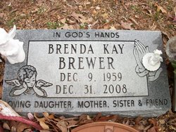
Brenda Kay Eaton Brewer
| Birth | : | 9 Dec 1959 Saint Louis, St. Louis City, Missouri, USA |
| Death | : | 31 Dec 2008 Piedmont, Wayne County, Missouri, USA |
| Burial | : | Terrace Heights Memorial Park, Yakima, Yakima County, USA |
| Coordinate | : | 46.6068600, -120.4598900 |
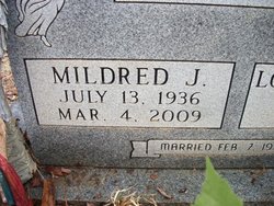
| Description | : | Brenda Kay Brewer, 49, died Dec. 31, 2008, at her home in Piedmont, Mo. She was born Dec. 9, 1959, in St. Louis, Mo., daughter of Lowell "Pete" and Mildred Eaton, who survive and reside in Piedmont. She was united in marriage to Robert Brewer Nov. 10, 1990. He survives. Mrs. Brewer was a homemaker. In addition to her husband and parents, she is survived by one daughter, Melanie Gail Smith, Dupo, IL.; one son, Joseph Shelby Smith, Poplar Bluff; two sisters, Dixie Gail Britt, Piedmont, Vernita Sue Eaton, Mill Spring; one brother, Lowell Steve Eaton, Mill Spring; one grandson, Christian Eli Scott Gourley,... Read More |
frequently asked questions (FAQ):
-
Where is Brenda Kay Eaton Brewer's memorial?
Brenda Kay Eaton Brewer's memorial is located at: Terrace Heights Memorial Park, Yakima, Yakima County, USA.
-
When did Brenda Kay Eaton Brewer death?
Brenda Kay Eaton Brewer death on 31 Dec 2008 in Piedmont, Wayne County, Missouri, USA
-
Where are the coordinates of the Brenda Kay Eaton Brewer's memorial?
Latitude: 46.6068600
Longitude: -120.4598900
Family Members:
Parent
Nearby Cemetories:
1. Terrace Heights Memorial Park
Yakima, Yakima County, USA
Coordinate: 46.6068600, -120.4598900
2. Pioneer Cemetery
Union Gap, Yakima County, USA
Coordinate: 46.5578003, -120.4697037
3. Holland Cemetery
Moxee City, Yakima County, USA
Coordinate: 46.5766983, -120.3861008
4. Tahoma Cemetery
Yakima, Yakima County, USA
Coordinate: 46.5753610, -120.5332320
5. Calvary Cemetery
Yakima, Yakima County, USA
Coordinate: 46.5790740, -120.5407420
6. Lewis Family Cemetery
Yakima, Yakima County, USA
Coordinate: 46.5390013, -120.5052581
7. Selah Pioneer Cemetery
Selah, Yakima County, USA
Coordinate: 46.6720000, -120.5140000
8. Union Gap Cemetery
Yakima County, USA
Coordinate: 46.5209084, -120.4850998
9. Holy Rosary Cemetery
Moxee City, Yakima County, USA
Coordinate: 46.5531006, -120.3585968
10. Nelson Pioneer Cemetery
Yakima County, USA
Coordinate: 46.6404310, -120.5831510
11. Yemowat Cemetery
Yakima County, USA
Coordinate: 46.5475006, -120.5730972
12. West Hills Memorial Park
Yakima, Yakima County, USA
Coordinate: 46.5819016, -120.6647034
13. Emeunot Cemetery
Wapato, Yakima County, USA
Coordinate: 46.5243988, -120.6616974
14. Cowiche Natchez Cemetery
Cowiche, Yakima County, USA
Coordinate: 46.6490840, -120.6885330
15. Reservation Community Memorial Park
Wapato, Yakima County, USA
Coordinate: 46.4484291, -120.5375519
16. Sloutier Cemetery
Yakima County, USA
Coordinate: 46.5231018, -120.6722031
17. Saluskin Cemetery
Yakima County, USA
Coordinate: 46.5266991, -120.7039032
18. Naches Cemetery
Naches, Yakima County, USA
Coordinate: 46.7299530, -120.6896990
19. Wenas Cemetery
Selah, Yakima County, USA
Coordinate: 46.7743988, -120.6243973
20. Wymer Cemetery
Wymer, Kittitas County, USA
Coordinate: 46.8267433, -120.4617911
21. Zillah Cemetery
Zillah, Yakima County, USA
Coordinate: 46.4055202, -120.2726072
22. Zillah German Baptist Cemetery
Zillah, Yakima County, USA
Coordinate: 46.4128550, -120.2506400
23. Elmwood Cemetery
Toppenish, Yakima County, USA
Coordinate: 46.3673830, -120.3334530
24. McCoy Cemetery
Toppenish, Yakima County, USA
Coordinate: 46.3835983, -120.2755966


